
Accordingly, the planning area belongs to the administrative boundary of Tan An town and the communes of Lao Ho, Xuan Phu and part of Huong Gian commune. The boundary is limited to the North by Thai Dao commune, Lang Giang district; to the South by Thuong river; to the East by Quynh Son commune, Lang Son and Luc Nam district; to the West by Huong Gian commune, Thuong river.
The area of the research area is about 2,048 hectares. The population by 2045 is about 60,000 people. In nature, this is an auxiliary urban area associated with the agricultural gateway, the Man stream flowing into the Luc Nam river, low hills in the Lao Ho area, Quynh Son and the Tay Yen Tu tourist area. The complex service center supports the surrounding industrial parks.
The functional zoning plan of urban area 6, Bac Giang urban area, Bac Giang province is divided into 4 planning areas, depending on the natural terrain and potential, internal development of each area to propose separate functions for each development area and ensure the standards for forming residential units and targets according to regulations.
Area A: Eastern gateway area. Located in the East of the planning area. The Southwest borders the Ring Road 5 of the Capital region; is an amusement park combining intangible cultural forms and a large water surface area - Man stream, a symbol of Bac Giang city in the Eastern gateway area. The total area of Area A is about 186.43 hectares, with a population of about 400 people.
Area B: Lao Ho commune area. The East borders the Capital's Ring Road 5; the West borders the Ring Road 2; the South borders Quynh Son commune; the North borders Thai Dao commune, Lang Giang district; is an ecological urban area combining the preservation of the existing village space structure and the development of agricultural eco-tourism services, low hilly landscapes of Lao Ho commune area associated with Ngoi Man amusement park in the East. The total area of Area B is about 333.61 hectares, with a population of about 9,500 people.
Area C: Tan An town center. The East borders the Ring Road 2; the West borders Huong Gian commune; the South borders the planned road with a cross-section of 50m; the North borders Thai Dao commune, Lang Giang district; is an auxiliary urban area providing 3 effective services for the surrounding areas, developing on the basis of the existing Tan An town center, supplementing social infrastructure, technical infrastructure, forming a new administrative center at the ward level in accordance with the criteria by 2030 to basically complete the arrangement of commune-level administrative units in Bac Giang city. The total area of area C is about 678.92 hectares, with a population of about 34,000 people.
Area D: Xuan Phu commune area. The East borders Quynh Son commune; the West and South borders Thuong River; the North borders Huong Gian commune, with the function defined as an urban area, service center, mixed and auxiliary for the Regional General Hospital, creating a health care complex. Organizing open spaces connecting the Thuong River area, which are agricultural ecological buffer zones, creating green landscape spaces, improving the quality of the living environment in the area. The total area of area D is about 738.51 hectares, with a population of about 16,100 people.
The People's Committee of Bac Giang province has just issued a decision approving the project to adjust the planning of subdivision 2, subdivision 8 of Bac Giang urban area, Bac Giang province, scale 1/2,000.
Zone 2 belongs to the administrative boundaries of wards and communes: Le Loi, Dinh Ke, Tan Tien, Dinh Tri of Bac Giang city and Huong Gian, Xuan Phu communes, Tan An town of Yen Dung district. The boundary is limited to the Northeast by Thai Dao commune (Lang Giang district); to the South and Southwest by Thuong river dike; to the East by Tan An planning road (in Tan An town, Yen Dung district); to the Northwest by Hanoi - Lang Son highway.
The planned area is about 2,247 hectares. The total population by 2030 is about 66,000 people; by 2045 the total population is about 105,000 people.
Sub-area 2, Bac Giang urban area is a complex urban area, a new multi-functional center of Bac Giang city, with ecological urban space associated with green landscape, water surface and urban public service works.
Meanwhile, subdivision 8, Bac Giang urban area has administrative boundaries belonging to Nham Bien town and Yen Lu, Canh Thuy, Tien Dung communes. The boundary is limited to the north by the foot of Nham Bien mountain and Thuong river; to the southwest by Cau river and Que Vo town, Bac Ninh province; to the east by Duc Giang commune and Tu Mai commune. According to the plan, subdivision 8 has an area of about 4,378 hectares. The population size by 2045 is 90,000 people.
Sub-zone 8, Bac Giang urban area is characterized as a southern gateway urban area, an important traffic hub connecting with Bac Ninh, Hai Duong and Quang Ninh provinces. A creative and production urban area, a new economic development pole of Bac Giang urban area with an attractive and modern ecological urban space.
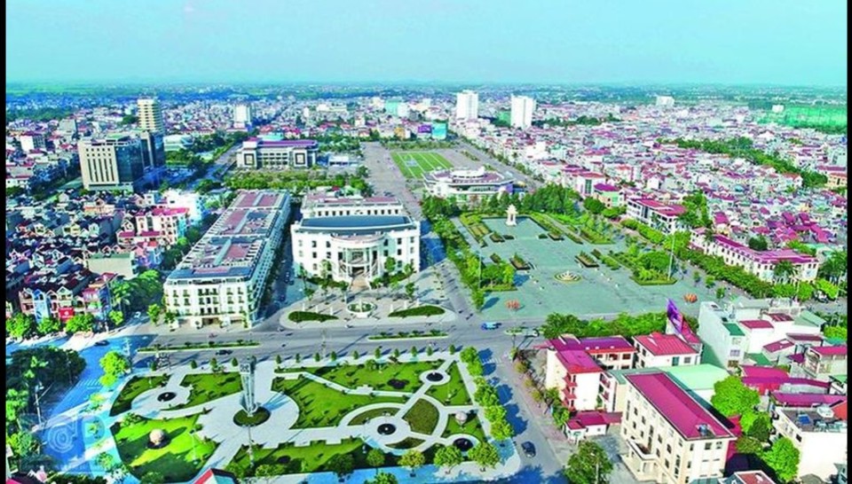
At the end of December 2023, the Prime Minister issued Decision No. 1685/QD-TTg approving the Bac Giang Urban Master Plan until 2045, scale 1/10,000. Accordingly, the scope and boundary of the planning includes the entire natural land area of Bac Giang City and the existing Yen Dung District. The planning area is about 25,830 hectares. Of which, Bac Giang City is about 6,656 hectares, the rest is Yen Dung District.
Source: https://kinhtedothi.vn/bac-giang-duyet-loat-do-an-quy-hoach-phan-khu-do-thi-gan-26-000-ha.html


Comment (0)