
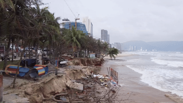
According to the National Center for Hydro-Meteorological Forecasting, due to the influence of the tropical depression , there has been moderate rain, heavy rain, and very heavy rain in some places in the North and Central Central regions.
Rainfall from 0-13:00 today (September 25) is generally 50-80mm, locally over 150mm in some places such as: Huong Phu (Thua Thien Hue) 283mm, Da Nang 197mm, Trieu Ai (Quang Tri) 187mm, Huong Thuy (Ha Tinh) 186mm, Hoi An (Quang Nam) 171mm, ...

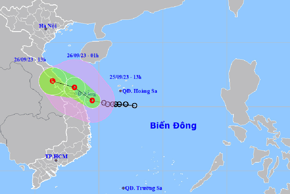
At 1 p.m., the center of the tropical depression was at about 15.5 degrees North latitude; 109.5 degrees East longitude, about 150km East Southeast of Da Nang, about 80km East Northeast of Quang Ngai. The strongest wind near the center of the tropical depression was level 6-7 (39-61km/h), gusting to level 8-9. Moving in the West Northwest direction at a speed of 15km/h.
In the next 24-48 hours, the tropical depression will maintain its direction and speed of movement, entering the sea area from Quang Binh - Thua Thien Hue with winds of level 6-7, gusting to 9. When the tropical depression enters the mainland of Quang Tri - Quang Nam, the wind speed will gradually decrease, remaining below level 6.
Due to the influence of the tropical depression, the southwestern sea area of the North East Sea (including the sea area of Hoang Sa archipelago) has showers and strong thunderstorms, strong winds of level 6-7, gusts of level 9, rough seas, waves 2-4m high.
The South China Sea area (including the Truong Sa archipelago), the sea area from Binh Thuan to Ca Mau has strong southwest winds of level 6, gusting to level 7-8, rough seas, waves 2-3.5m high.
At the same time, the sea area from Quang Tri to Quang Nam (including Con Co and Cu Lao Cham island districts) has strong winds of level 6-7, gusts of level 9, rough seas, and waves gradually rising 2-30m.
The wind in the Gulf of Tonkin gradually increased to level 6, gusting to level 7-8, rough seas, and waves gradually increased to 1.5-2.5m.
The North and Central Central regions have the heaviest rain this time.
The meteorological agency said that from tonight to tomorrow morning (September 26), coastal areas from Quang Binh to Quang Nam should be on guard for strong winds of level 6, gusting to level 8; further inland, gusting to level 6-7.
From now until September 27, the weather in the Central Central region will have heavy to very heavy rain with common rainfall from 100-200mm, especially in Quang Tri-Thua Thien Hue, some places will have over 200mm.
In the South Central, Central Highlands and South, there will be moderate rain, heavy rain and thunderstorms, locally very heavy rain with rainfall from 100-150mm, in some places over 200mm.
From now until September 28, in the area from Thanh Hoa to Quang Binh, there will be heavy to very heavy rain with common rainfall from 200-400mm, in some places over 450mm.
Previously, speaking with VietNamNet reporter , Dr. Hoang Phuc Lam, Deputy Director of the National Center for Hydro-Meteorological Forecasting, also said that from this evening and tonight, heavy to very heavy rain will concentrate in the Central Central region, then spread to the North Central region.
"These will be the two areas with the heaviest rain during this period and it may last until the night of September 27," Dr. Lam said.
In addition, Mr. Lam added that this tropical depression is unlikely to directly affect the weather in the capital Hanoi , but will still cause rain and moderate rain for this area and the Northern Delta from the evening and night of September 26.

Source


Comment (0)