
A tropical depression formed in the central East Sea this morning with the strongest wind at level 6, then moved slowly towards the sea area of Binh Dinh - Ninh Thuan.
According to the National Center for Hydro-Meteorological Forecasting, this morning (February 12), the low pressure area in the central East Sea has strengthened into a tropical depression.
At 7:00 a.m., the center of the tropical depression was at about 12.0 degrees North latitude; 112.5 degrees East longitude, in the northwest area of Truong Sa archipelago. The strongest wind near the center of the tropical depression was level 6 (39-49 km/h), gusting to level 8; moving slowly in the northwest direction at a speed of about 5 km/h.
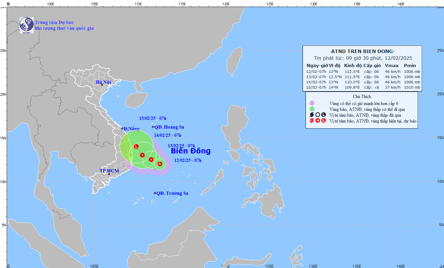
In the next 24 hours, the tropical depression will maintain its direction and continue to move slowly at 5km/h. By 7am tomorrow morning (February 13), the center of the tropical depression will be over the western sea area of the Central East Sea with the strongest wind speed of level 6, gusting to 8.
Maintaining the same direction and speed of movement for the next 24 hours, at 7:00 a.m. on February 14, the center of the tropical depression was in the offshore waters from Binh Dinh to Ninh Thuan.
Over the next 48 to 72 hours, the tropical depression will move slowly to the northwest and gradually weaken.
The meteorological agency warned that the impact of the tropical depression will cause showers and thunderstorms in the western sea area of the Central East Sea and the southwestern sea area of the Northern East Sea; and offshore waters from Phu Yen to Ninh Thuan, with strong winds of level 6, gusts of level 8, and rough seas.
The western sea area of the Central East Sea and the southwestern sea area of the North East Sea (including the sea area of the Hoang Sa archipelago) have waves 2-3.5m high.
From February 14, the offshore sea area from Thua Thien Hue to Binh Dinh has waves 2-3m high.
Ships operating in the above mentioned dangerous areas are susceptible to the effects of storms, whirlwinds, strong winds and large waves.
Cold air presses
Also this morning, the National Center for Hydro-Meteorological Forecasting said that a cold air mass is moving south from the North.
It is forecasted that around tonight and tomorrow morning (February 13), this cold air mass will affect the Northeast region, then affect the North Central region and some places in the Northwest region.

In the North and North Central regions from tomorrow, it will be cold, with some mountainous areas in the North experiencing severe cold. The lowest temperature during this cold spell in the North will generally be 14-17 degrees Celsius, in mountainous areas 11-13 degrees, in high mountainous areas below 10 degrees in some places; in the North Central region 16-18 degrees.
Hanoi area from tomorrow will be cold. The lowest temperature in this cold air mass is commonly 15-17 degrees.
Due to the influence of cold air strengthening combined with strong currents in the upper westerly wind zone, from tonight until tomorrow, the Northeast and North Central regions will have rain, light rain.
From early tomorrow morning, in the Gulf of Tonkin, the wind will change direction to strong Northeast level 5, in the North at times level 6, gusting to level 7-8, rough sea, waves 1.5-2.5m high; in the North East Sea (including the waters of Hoang Sa archipelago), the Northeast wind will gradually increase to level 6, gusting to level 7-8, rough sea, waves 2-4.5m high.

Tropical depression likely to form in southern sea, Ho Chi Minh City has unseasonal rain

Weather forecast for the next 10 days: The North will welcome 2 more cold air waves with rain
Source: https://vietnamnet.vn/ap-thap-nhiet-doi-hinh-thanh-huong-ve-vung-bien-binh-dinh-ninh-thuan-2370583.html
![[Photo] General Secretary To Lam concludes visit to Russia, departs for Belarus](https://vphoto.vietnam.vn/thumb/1200x675/vietnam/resource/IMAGE/2025/5/11/0acf1081a95e4b1d9886c67fdafd95ed)

![[Photo] National Assembly Chairman Tran Thanh Man attends the Party Congress of the Committee for Culture and Social Affairs](https://vphoto.vietnam.vn/thumb/1200x675/vietnam/resource/IMAGE/2025/5/11/f5ed02beb9404bca998a08b34ef255a6)


![[Photo] Discover the beautiful scenery of Wulingyuan in Zhangjiajie, China](https://vphoto.vietnam.vn/thumb/1200x675/vietnam/resource/IMAGE/2025/5/11/1207318fb0b0467fb0f5ea4869da5517)


Comment (0)