
The Sentinel-6 Michael Freilich satellite recorded Kelvin waves moving eastward across the Pacific Ocean, a phenomenon often seen as a sign of El Niño.
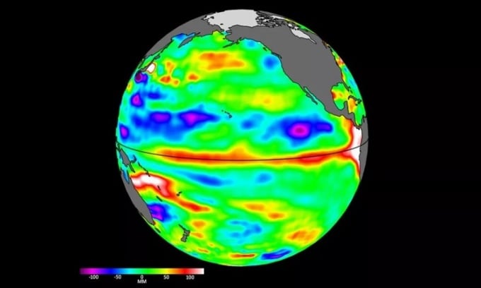
Data from the Sentinel-6 satellite on April 24 showed higher and warmer sea levels at the equator and the west coast of South America. Photo: NASA
NASA identified early signs of El Niño from space after one of its satellites detected warm Pacific waters moving eastward toward the western coast of South America in March and April. Data from the Sentinel-6 Michael Freilich satellite, which monitors sea levels, showed Kelvin waves moving across the Pacific Ocean. These long currents are only 5 to 10 centimeters (2 to 4 inches) high but hundreds of kilometers wide. They are considered a precursor to El Niño when they form at the equator and move warm upper waters to the western Pacific, Live Science reported on May 16.
“We’re tracking El Niño like a falcon,” said Josh Willis, Sentinel-6 Michael Freilich project scientist at NASA’s Jet Propulsion Laboratory (JPL). “If it’s a strong El Niño, the world will experience record-breaking warming.”
El Niño is part of the El Niño-Southern Oscillation (ENSO) climate cycle. Normally, trade winds blow surface water westward across the Pacific Ocean, moving warm water from South America to Asia. As the warm water moves, cold water rises to replace it. El Niño involves weak trade winds, which push warm water eastward. This has a major impact on weather patterns around the world. For the United States, the result is wetter weather in the south and warmer weather in the northwest. Meanwhile, La Niña has the opposite effect, with strong trade winds pushing more warm water westward.
El Niño typically occurs every 3-5 years, but it can occur more frequently. The most recent El Niño was in 2019 and lasted 6 months, from February to August. On May 11, a representative of the US National Oceanic and Atmospheric Administration (NOAA) said there is a 90% chance that El Niño will occur this year and last until winter in the Northern Hemisphere. According to NOAA's prediction, there is an 80% chance of a moderate El Niño, in which the ocean surface temperature increases by 1 degree Celsius, and a 55% chance of a strong El Niño, in which the ocean surface temperature increases by 1.5 degrees Celsius.
In a May 12 announcement from JPL, images taken by the Sentinel-6 satellite from early March to late April show Kelvin waves pushing warmer water eastward, centered off the coasts of Colombia, Ecuador, and Peru. The red and white areas in the image represent warmer water and higher sea levels. NOAA and NASA will continue to monitor conditions in the Pacific Ocean over the next few months to determine if, when, and how strong El Niño will develop.
In April, scientists recorded the highest ocean surface temperature on record, with a global average of 21.1 degrees Celsius. The record reflects the impact of climate change and the end of the most recent La Niña. The combination of El Niño and super-high ocean temperatures could create a series of records over the next 12 months.
An Khang (According to Live Science )
Source link


![[Photo] Prime Minister Pham Minh Chinh receives French Minister in charge of Transport](https://vstatic.vietnam.vn/vietnam/resource/IMAGE/2025/3/21/aa649691f85546d59c3624b1821ab6e2)
![[Photo] Meet the pilots of the Victory Squadron](https://vstatic.vietnam.vn/vietnam/resource/IMAGE/2025/3/21/fd30103acbd744b89568ca707378d532)
![[Photo] Prime Minister Pham Minh Chinh receives the head of the Republic of Tatarstan, Russian Federation](https://vstatic.vietnam.vn/vietnam/resource/IMAGE/2025/3/21/7877cb55fc794acdb7925c4cf893c5a1)


Comment (0)