
Clip: The water level of the Red River passing through Lao Cai is receding after suddenly rising.
Accordingly, from the night of September 30 to the morning of October 1, Lao Cai province experienced heavy rain and floods reappeared on rivers and streams. At around 8am this morning, the water level on the Red River in Lao Cai city was 80.60m, above alert level 1 and is forecast to peak at around 1pm this afternoon (October 1), at approximately alert level 2 (82m).
However, after recording the actual situation at the embankment area of An Duong Vuong street, Kim Tan ward, Lao Cai city, the water level on the Red River is gradually receding.
Many people living near the river embankment said that, according to naked eye observations, the water level of the Red River is gradually receding compared to early this morning (October 1).
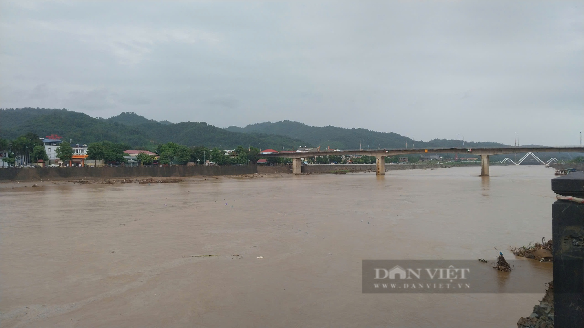
The water level of the Red River passing through Lao Cai is receding after suddenly rising. Photo: Spring.
According to Lao Cai Province's Hydrometeorological Station, in the past 24 hours (from 2:00 p.m. on September 30 to 2:00 p.m. on October 1), Lao Cai province has had moderate to heavy rain, and some places have had very heavy rain such as: Ta Giang Phinh 318.6mm, Ngu Chi Son 317.2mm, Ban Khoang 225.2mm, Trung Chai 194.8mm in Sa Pa town; Nam Pung 220.6mm, Pa Cheo 214.8mm, Den Thang 206.4mm, Muong Hum 198mm, Bat Xat district; Ta Phoi 100.8mm, Coc San 99.6mm in Lao Cai city; Bao Ha 2 129.6mm, Bao Ha 1 129.6mm, Kim Son 98mm, Tan Duong 92.6mm, Bao Yen district; Son Thuy 120.4mm, Chieng Ken 86.6mm Van Ban district; Nam Phang Hydropower Plant (Nam Khanh) 119.4mm, Ban Cai 102mm, Nam Det 101.4mm; Bao Nhai 104.7mm Coc Lau 107mm, Bac Ha district, the remaining areas have common accumulated rainfall from 80 - 100mm.

Currently, Lao Cai province is still experiencing light to moderate rain. Photo: Spring.
Soil moisture models show that some areas in the districts of Bac Ha, Bao Thang, Bao Yen, Bat Xat, Simacai, Lao Cai city, Sa Pa town, Van Ban, Muong Khuong are nearly saturated (over 95%) or have reached saturation.
Rain warning: In the next 6 hours, Lao Cai province will continue to have moderate rain, some places will have heavy rain, with accumulated rainfall from 30 - 50mm, some places over 70mm, risk of flash floods on small rivers and streams in mountainous areas; landslides on steep slopes, land subsidence in the areas of Bac Ha, Bao Yen, Bat Xat, Muong Khuong districts, Lao Cai city, Sa Pa town, Van Ban, Bao Yen, Bao Thang.

The water level of the Red River suddenly receded after rising suddenly this morning (October 1). Photo: Spring.
Warning level of natural disaster risk due to flash floods, landslides, land subsidence due to heavy rain or water flow at level 2.
Warning of the impact of flash floods, landslides, and land subsidence caused by heavy rain or flash flood flows and landslides that can impact the environment, threaten people's lives; cause traffic jams, affect the travel and movement of vehicles; destroy civil and economic works, causing damage to production and socio-economic activities.
Source: https://danviet.vn/muc-nuoc-song-hong-dang-rut-dan-sau-khi-bat-ngo-dang-cao-lao-cai-canh-bao-nguy-co-lu-quet-sat-lo-dat-20241001150826971.htm


![[Photo] Prime Minister Pham Minh Chinh chairs Government Conference with localities on economic growth](https://vstatic.vietnam.vn/vietnam/resource/IMAGE/2025/2/21/f34583484f2643a2a2b72168a0d64baa)


Comment (0)