
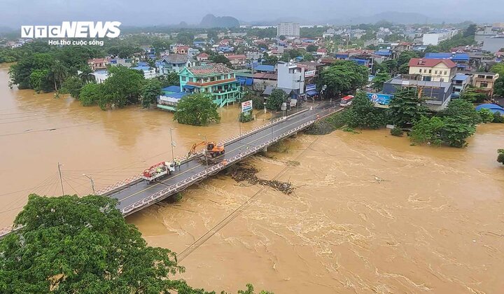
At 7:00 a.m. on September 10, the water level on the Cau River at Gia Bay Hydrological Station (Thai Nguyen City) had decreased by 17cm compared to the flood peak but was still 164cm higher than alert level 3.
On the morning of September 10, according to information from the Thai Nguyen Hydrometeorological Station, on the Cau River at Gia Bay Hydrological Station, the flood peaked at 1:00 a.m. on September 10, at 2,881 cm. This flood peak is 73 cm higher than the historical flood peak that appeared on July 5, 2001 and 181 cm higher than the level 3 warning.
Currently, at 7:00 a.m. on September 10, the flood reached 2,864 cm (down 17 cm from the flood peak), 5 cm higher than the historic flood that occurred on July 5, 2001 and 164 cm higher than the level 3 warning.
At Cha Hydrological Station at 7:00 a.m. on September 10, the flood level was at 966cm and continued to increase.
It is forecasted that in the next 24 hours, on Cau River at Gia Bay Hydrological Station, the flood will continue to decrease but will still remain at a high level.
At Cha Hydrological Station, floods continue to increase and are likely to reach level 3 warning on the evening of September 10.
According to the Thai Nguyen Hydrometeorological Station, this is a complicated flood due to the impact of local heavy rains upstream, increasing the level of prolonged riverside flooding, the risk of riverbank and dike landslides, causing flooding in low-lying areas and most areas in the center of Thai Nguyen city.
Flood disaster risk warning level is level 3.
The flood water level in the river rose, causing deep flooding, affecting traffic and the lives of many residential areas living along both banks of the Cau River. Specifically:
Flooding in low-lying areas and areas along the Cau River in Dong Hy and Phu Binh districts, Pho Yen city and Thai Nguyen city.
Flooding on some roads and residential areas in the center of Thai Nguyen City: Quang Vinh, Dong Tam, Trung Vuong, Tuc Duyen, Cao Ngan, Cam Gia wards; the leveled intersection, the Provincial Party Committee intersection, Hung Vuong street and some main streets...
Rising floodwaters cause flooding with a maximum depth of 0.3-0.5m, in some places higher than 0.7m; flooding time is generally from 12-24 hours, in some places longer.
Floods have caused dangerous impacts in some areas of underground spillways, spillways, pontoon bridges, and weak dykes along both banks of the downstream Cau River, threatening people's lives and property and socio-economic activities.
| According to the National Center for Hydro-Meteorological Forecasting, from the morning of September 10 to the night of September 10, the midlands and mountainous areas of the North will have moderate rain, heavy rain, some places with very heavy rain and thunderstorms, with rainfall ranging from 40-80mm, and over 150mm in some places. In particular, Lao Cai and Yen Bai will have heavy to very heavy rain with rainfall ranging from 50-120mm, and over 250mm in some places. During the day and night of September 11, this area will have moderate rain, heavy rain, some places with very heavy rain and thunderstorms, with rainfall ranging from 30-60mm, and over 120mm in some places. From the morning of September 10 to the night of September 10, the Northern Delta, Hoa Binh, Thanh Hoa and Nghe An will have heavy to very heavy rain and scattered thunderstorms with rainfall ranging from 50-120mm, and over 300mm in some places. During the day and night of September 11, this area will have moderate rain, heavy rain, and in some places very heavy rain and thunderstorms with common rainfall of 40-90mm, locally over 200mm. |


Comment (0)