
The National Center for Hydro-Meteorological Forecasting has just made a climate trend assessment for the period of June 2024.
Accordingly, Deputy Head of Climate Forecasting Department Tran Thi Chuc said that the average temperature across the country is generally 0.5-1 degree Celsius higher than the average of many years (TBNN), with some places in the Central and South Central regions being 1 degree higher than the TBNN for the same period.
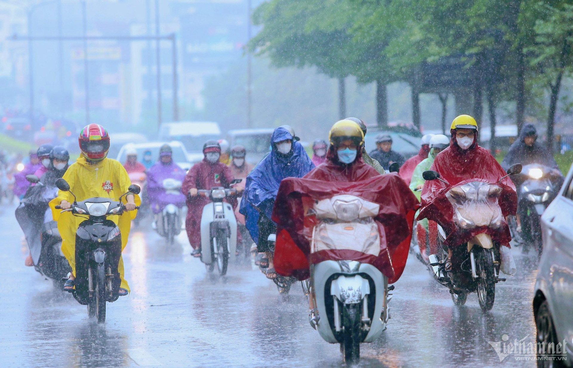
Notably, during the forecast period, the Northern and North Central regions will have many rainy days, especially in the first 10 days of the month, the region is likely to experience widespread moderate and heavy rain.
In the Central Highlands and Southern regions, the southwest monsoon tends to become stronger, so rain is likely to increase in both area and quantity.
Therefore, total rainfall in the North and North Central regions during this period is 10-30% higher than the average, while other regions are approximately the same.
At the same time, Ms. Tran Thi Chuc noted that this June, there is a possibility of 1-2 storms/tropical storms appearing in the East Sea (including storm No. 1 (Maliksi).
Regarding the development of heat waves, according to Ms. Chuc, in the first 10 days of the forecast period, there is little possibility of widespread heat waves. After that, heat waves are likely to increase in the Northern and Central provinces.
In the immediate future, the meteorological agency will provide short-term weather forecasts for regions across the country, from June 1-7.
Specifically, in the Northern region from June 1-2, there will be scattered showers and thunderstorms, with intermittent sunny days. From the evening of June 2-3, there will be sunny days, scattered thunderstorms in the evening and at night, with some areas having moderate to heavy rain. Notably, from June 4-7, there will be rain, moderate rain and thunderstorms, with some areas having heavy to very heavy rain.
In addition, from June 4-6, there is a possibility of a flood occurring on rivers and streams in the Northern region with a common flood amplitude of 1-3m.
Central region : From June 1-4, sunny days, especially from April 3-4, hot, extremely hot in some places; localized thunderstorms in the evening and at night.
From the night of June 4-7: the North Central region has scattered thunderstorms, locally heavy rain; the Central and South Central regions have hot sunny days, with local thunderstorms in the late afternoon and evening.
In the Central Highlands and the South , this week, there will be sunny days, scattered thunderstorms in the late afternoon and evening, and locally heavy rain.
In Hanoi area : From June 1-2, there will be showers and thunderstorms in some places, with intermittent sunny days. From the evening of June 2-3, there will be sunny days, with scattered thunderstorms in the evening and at night. From June 4-7, there will be rain, moderate rain and thunderstorms, with localized heavy rain.
The meteorological agency warns that in the above areas, thunderstorms may cause tornadoes, lightning, hail and strong gusts of wind.
The first storm appeared in May Assessing the weather situation in May, Deputy Head of the Climate Forecasting Department Tran Thi Chuc said that the first storm of 2024 appeared in the East Sea with the international name Maliksi on the afternoon of May 31. By the morning of June 1, after making landfall in the southern region of Guangdong Province (China), the storm gradually weakened. Regarding climate developments, in the Northern and Central Deltas, there was a heat wave during this period, with some places experiencing severe heat from May 26-30; in which, the area from Thanh Hoa to Ninh Thuan experienced severe heat, with some places experiencing especially severe heat with the highest daily temperature commonly ranging from 36-39 degrees, with some places over 40 degrees. The Southern region will experience hot and extremely hot weather from May 1-8; then from May 9, the heat will mainly be concentrated in the Southeast provinces. Many meteorological stations across the country have recorded the highest daily temperature value exceeding historical values. Specifically, on the same day, May 1, in Dong Ha (Quang Tri), it reached 43.2 degrees, exceeding the 42.3 degree mark set in 2023; Hue (Thua Thien Hue) 42.1 degrees, exceeding the record of 41.3 degrees in 1983; Da Nang 41.5, exceeding the 40.5 mark set in 1983; or Thu Dau Mot (Binh Duong) 38.9 degrees on May 2, exceeding the 38.7 mark set in 2016, etc. The average temperature in May in the North is approximately the same as the average for many years (TBNN) in the same period; in the Southern part of the Northern Delta, it is 1-1.5 degrees higher. In the Central provinces, it is 0.5-1.5 degrees higher. In the Central Highlands and the South, it is 1-2 degrees higher, and in some places, over 2 degrees higher than the TBNN in the same period. In addition, May also recorded many rainy days in regions across the country, but the distribution was uneven. Specifically, the total rainfall in the North, Central Central, some places in the South Central and Southeast regions was approximately 30-60% higher, in some places 80-100% higher than the average. Meanwhile, in the North Central, Central Highlands and Southwest regions, rainfall was 15-30% lower, in some places 50% lower than the average for the same period. |

Source: https://vietnamnet.vn/mien-bac-sap-co-dot-mua-lon-thang-6-kha-nang-xuat-hien-bao-2286896.html


![[Photo] Prime Minister Pham Minh Chinh chairs Government Conference with localities on economic growth](https://vstatic.vietnam.vn/vietnam/resource/IMAGE/2025/2/21/f34583484f2643a2a2b72168a0d64baa)


Comment (0)