
Storm No. 1 is unlikely to affect our mainland.
Experts predict the probability of storm number 1 affecting our mainland.
This afternoon (May 31), the tropical depression in the northern area of the Paracel Islands has strengthened into a storm, with the international name Maliksi. This is the first storm of 2024 to operate in the East Sea and the second storm to operate in the Northwest Pacific.
Sharing with Dan Viet, Mr. Nguyen Van Huong - Head of Weather Forecast Department, National Center for Hydro-Meteorological Forecasting said that according to the forecast, in the next 12 hours, storm No. 1 will move mainly in the North direction, it is likely that tonight and early tomorrow morning, June 1, the storm will make landfall in the South of Guangdong province (China).
The storm then changed direction, moving north-northeast and weakened into a tropical depression, then a low-pressure area, dissipating over mainland China.
The Head of the Weather Forecast Department, National Center for Hydro-Meteorological Forecasting added: "Storm No. 1 is unlikely to affect our mainland. However, the storm also causes strong winds of level 6, gusting to level 7-8 in the northern East Sea, and winds near the center of the storm are strong at level 7-8, gusting to level 10.
In addition, the eastern area of the North East Sea, the central sea area of the East Sea, the sea area from Da Nang to Quang Ngai, Binh Dinh, Ninh Thuan also has strong southwest winds of level 5, sometimes level 6, waves 2-3m high, rough seas, widespread thunderstorms accompanied by the risk of tornadoes and gusts of wind."
On the mainland of our country, this evening and tonight, May 31, from Thanh Hoa to Quang Binh, there will be scattered showers and thunderstorms, locally heavy rain with rainfall of 15-30 mm, in some places over 70 mm.
In the afternoon and evening of May 31, the Central Highlands and the South will have scattered showers and thunderstorms, locally heavy rain with rainfall of 10-30 mm, in some places over 50 mm.
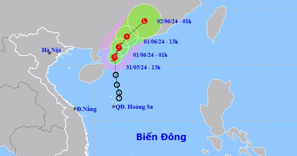
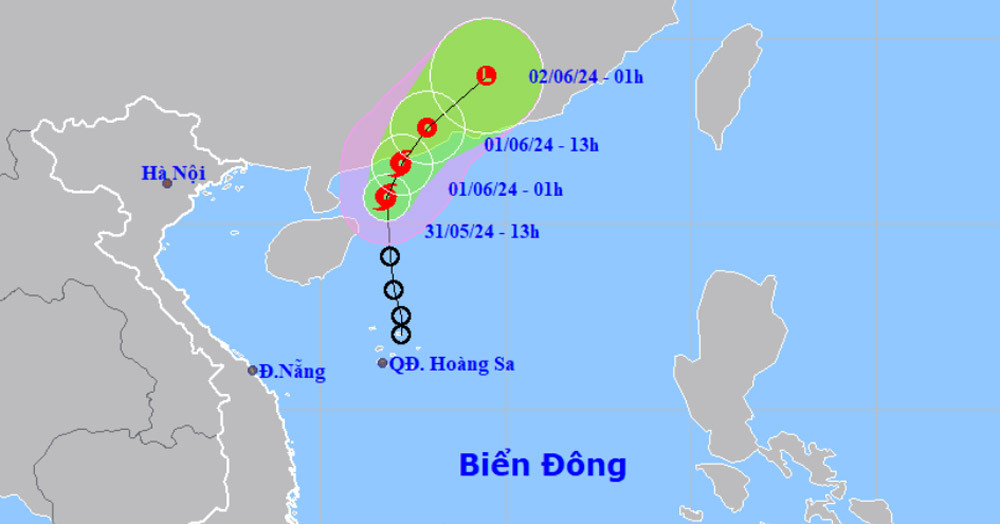
Location and path of storm number 1
According to the latest update from the National Center for Hydro-Meteorological Forecasting, at 7:00 p.m. on May 31, the center of the storm was located at approximately 20.8 degrees North latitude; 111.8 degrees East longitude, in the sea south of Guangdong province (China). The strongest wind near the center of the storm is level 8 (62-74 km/h), gusting to level 10; moving north at a speed of 5 km/h.

Forecast of the path of storm No. 1. (Source: National Center for Hydro-Meteorological Forecasting)
Forecast of storm No. 1 in the next 24 to 48 hours
Weather forecast for regions across the country on the night of May 31 and June 1, 2024
Hanoi Showers and thunderstorms in some places, sunny in the afternoon. North to northwest wind level 2-3. Lowest temperature 24-26 degrees Celsius. Highest temperature 31-33 degrees Celsius.
Northwest Showers and thunderstorms in some places, scattered showers and thunderstorms in the Northwest in the evening and at night. Light wind. During thunderstorms, tornadoes, lightning, hail and strong gusts of wind may occur. Lowest temperature 23-26 degrees Celsius, some places below 22 degrees Celsius. Highest temperature 29-32 degrees Celsius, some places above 32 degrees Celsius.
Northeast Showers and thunderstorms in some places. North to northwest wind level 2-3. During thunderstorms, there is a risk of tornadoes, lightning, hail and strong gusts of wind. Lowest temperature 23-26 degrees Celsius. Highest temperature 30-33 degrees Celsius.
Thanh Hoa - Thua Thien Hue scattered showers and thunderstorms, locally heavy rain, Quang Tri - Thua Thien Hue showers and thunderstorms in some places. West to northwest wind level 2-3. During thunderstorms, beware of tornadoes, lightning, hail and strong gusts of wind. Lowest temperature 24-27 degrees Celsius. Highest temperature 29-32 degrees Celsius.
Da Nang to Binh Thuan In the evening and at night, there will be showers and thunderstorms in some places, and sunny days. Southwest wind level 2-3. During thunderstorms, there will be warnings of tornadoes, lightning, hail, and strong gusts of wind. Lowest temperature 26-29 degrees Celsius. Highest temperature 31-34 degrees Celsius, with some places above 34 degrees Celsius.
Central Highlands Showers and thunderstorms in some places, scattered showers and thunderstorms in the afternoon and evening, locally heavy rain. Southwest wind level 2-3. During thunderstorms, there is a possibility of tornadoes, lightning, hail and strong gusts of wind. Lowest temperature 21-24 degrees Celsius. Highest temperature 29-32 degrees Celsius, some places above 32 degrees Celsius.
Southern Vietnam Showers and thunderstorms in some places, scattered showers and thunderstorms in the afternoon and evening, locally heavy rain. Southwest wind level 2-3. During thunderstorms, tornadoes, lightning, hail and strong gusts of wind are forecast. Lowest temperature 25-28 degrees Celsius. Highest temperature 31-34 degrees Celsius, some places above 34 degrees Celsius.
Source: https://danviet.vn/chuyen-gia-khi-tuong-con-bao-so-1-tren-bien-dong-anh-huong-nhu-the-nao-toi-nuoc-ta-20240531211118895.htm


Comment (0)