
Forecast for the morning of November 11, the distance between storm No. 7 (YINXING) and storm TORAJI is about 1,200-1,400 km. This is the distance at which the double storm interaction occurs. Storm TORAJI will cause storm No. 7 (YINXING) to shift further south.
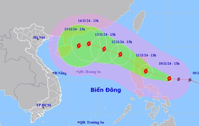
Typhoon TORAJI will shift Typhoon No. 7 (YINXING) further southward.
According to the National Center for Hydro-Meteorological Forecasting, currently storm number 7 with strong winds of level 12-13, gusting to level 16, along with that, the eastern region of the Philippines is experiencing a storm named TORAJI; forecasted on November 12, the storm will enter the East Sea.
On November 10, Head of Weather Forecast Department, National Center for Hydro-Meteorological Forecasting Nguyen Van Huong said that from the night of November 9 until now, storm No. 7 has moved into an area with environmental conditions unfavorable for the development of the storm.
Because the current sea surface temperature in the western part of the Paracel Islands is below optimal (below 26 degrees Celsius), it reduces the energy supply for storm No. 7, contributing to its gradual weakening.
Along with that, cold and dry air masses still prevail, so the relative humidity in the atmosphere from the ground to an altitude of 1,500 m is very low, limiting the development of storm clouds.
In addition, there is currently a new storm, internationally named TORAJI, active in the eastern part of the Philippines.
On the morning of November 11, when moving into the eastern region of Luzon Island (Philippines), the distance between storm No. 7 (YINXING) and storm TORAJI was about 1,200-1,400 km.
This is the distance where the double storm interaction occurs, storm TORAJI will cause storm No. 7 (YINXING) to shift more to the South.
It is forecasted that within the next 24-48 hours, storm No. 7 is expected to continue moving in a southwest direction and the storm's intensity will rapidly decrease to below level 10 due to unfavorable conditions of temperature and humidity.
Due to the impact of storm No. 7, the western sea area of the North East Sea has strong winds of level 7-9, near the storm's eye level 10-13, gusts of level 16, waves 4-6 m high, near the eye 6-8 m, rough seas.
From early morning on November 11, the sea area from Quang Tri to Quang Ngai has strong winds of level 6-7, near the storm's eye it has strong winds of level 8, gusts of level 10, waves 2-4 m high, near the storm's eye 3-5 m, rough seas.
Ships operating in the above mentioned dangerous areas are likely to be affected by storms, whirlwinds, strong winds and large waves.
On land, due to the influence of storm No. 7, from the evening and night of November 11 to the end of November 12, the Central and South Central regions will have rain but there is very little possibility of extreme rain causing flooding on rivers in the Central region.
These are impact warnings based on current data, people in the central coastal areas, especially from Quang Tri to Quang Ngai, need to closely monitor the storm situation and prepare response plans to minimize risks.
Storm TORAJI is likely to enter the East Sea, after storm number 7, storm number 8 will appear.
According to Mr. Nguyen Van Huong, currently in the eastern region of the Philippines there are 2 storms and 1 tropical depression active.
In particular, storm TORAJI is likely to move into the East Sea in the evening to the night of November 11; therefore, after storm number 7, storm number 8 will appear.
Under the impact of these two storms, the northern and central regions of the East Sea will continuously experience bad weather in the coming days, with strong winds, high waves and rough seas.
Telegram directing response to storm TORAJI
On November 10, the Minister of Agriculture and Rural Development issued Official Dispatch No. 8438/CD-BNN-DD to the People's Committees of coastal provinces and cities from Quang Ninh to Binh Thuan; the Ministries of National Defense, Public Security, Natural Resources and Environment, Transport, Industry and Trade, Information and Communications, Foreign Affairs; Vietnam News Agency, Vietnam Television, and Voice of Vietnam on responding to storm TORAJI near the East Sea.
According to the National Center for Hydro-Meteorological Forecasting, storm TORAJI is active in the sea east of Luzon Island (Philippines). It is forecasted that on November 12, the storm will enter the East Sea with a level 9 intensity, gusting to level 11.
To proactively respond to the storm, the Minister of Agriculture and Rural Development requested ministries, branches, and Chairmen of People's Committees of coastal provinces and cities from Quang Ninh to Binh Thuan to closely monitor the storm's developments and manage vessels going out to sea.
Organize the counting of ships and boats; notify owners of vehicles and captains of ships and boats operating at sea of the location, direction of movement and developments of the storm so that they can proactively avoid, escape or not move into dangerous areas.
Dangerous area in the next 24 hours, from latitude 16.5-21.0 degrees North latitude, East of longitude 119.0 degrees East longitude. Dangerous area in the next 48 hours from latitude 15.0-21.0 degrees North latitude, East of longitude 117.5 degrees East longitude (dangerous area is adjusted according to forecast bulletins).
Ministries, branches and localities are ready with forces and means for rescue when requested; at the same time, organize serious on-duty shifts (24/24 hours), regularly report to the Ministry of Agriculture and Rural Development (through the Department of Dyke Management and Disaster Prevention and Control).
Ministries and branches, according to their functions, state management tasks and assigned tasks, proactively direct and coordinate with localities to respond to storm developments.
Vietnam News Agency, Vietnam Television, Voice of Vietnam, the coastal information station system and mass media agencies from central to local levels have increased measures to inform authorities and people about the storm's developments so that they can proactively prevent and respond promptly and effectively.
Source chinhphu.vn
Source: https://baophutho.vn/chu-dong-ung-pho-bao-chong-bao-222449.htm


Comment (0)