
According to the provincial Hydrometeorological Station, from tonight (July 17), the sea area of Ha Tinh will have winds gradually increasing to level 5, then increasing to level 6, gusting to level 7.
At 4:00 a.m. this morning, the eye of the storm was located at approximately 20.0 degrees North latitude; 113.5 degrees East longitude, approximately 340 km East Southeast of Leizhou Peninsula (China). The strongest wind near the eye of the storm was level 11-12 (103-133 km/h), gusting to level 15.
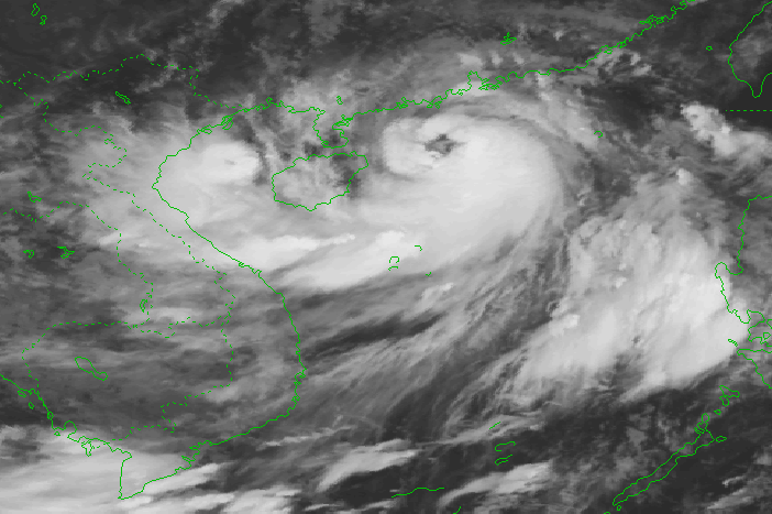
The center of the storm at 7:00 a.m. on July 17 was at approximately 20.1 degrees North latitude; 113.1 degrees East longitude.
From the night of July 17 to July 20, in the Northern region, there will be heavy to very heavy rain with common rainfall of 200-400mm, locally over 500mm; Thanh Hoa and Nghe An regions will have moderate to heavy rain, some places will have very heavy rain with common rainfall of 100-200mm, locally over 300mm. Beware of heavy rain causing urban flooding.
Heavy rains occurred after many days of thunderstorms and hot weather over the past 10 days, combined with rain in the coming days, causing the risk of flash floods and landslides to increase from July 18 in the Northern region, with high risks in the provinces of Quang Ninh, Lang Son, Cao Bang, Ha Giang, Lao Cai, and Yen Bai.
From early morning on July 18, coastal areas from Quang Ninh to Nam Dinh have winds gradually increasing to level 6-7, then increasing to level 8, areas near the storm center have winds of level 9-10, gusting to level 13; areas deep inland in the Northeast have strong winds of level 6-7, gusting to level 9.
The northern sea area of the North East Sea has strong winds of level 8-9, the area near the storm center has strong winds of level 11-12, gusting to level 15. The sea is very rough.
From around the afternoon of July 17, the northern Gulf of Tonkin (including Bach Long Vi and Co To island districts) will have winds gradually increasing to level 6-7, then increasing to level 8-9, near the storm center level 10-11, gusting to level 14. The sea will be very rough.
The northern sea area of the North East Sea has strong winds of level 8-9, the area near the storm center has strong winds of level 11-12, gusting to level 15. The sea is very rough.
The Central Highlands and the South have moderate rain, heavy rain and thunderstorms, locally very heavy rain with common rainfall of 60-120mm, some places over 150mm.
Beware of the risk of flash floods, landslides in mountainous areas and flooding in low-lying areas; beware of heavy rain in a short period of time causing flooding in urban areas. During thunderstorms, there is a possibility of tornadoes, lightning, hail and strong gusts of wind.
From around the afternoon of July 17, the northern Gulf of Tonkin (including Bach Long Vi and Co To island districts) will have winds gradually increasing to level 6-7, then increasing to level 8-9, near the storm center level 10-11, gusting to level 14. The sea will be very rough.
Due to the storm's influence, from the night of July 17, the sea area of Ha Tinh will have winds gradually increasing to level 5, then increasing to level 6, gusting to level 7; from July 17 to 20, the province will have scattered showers and thunderstorms in the afternoon and at night, with some places experiencing moderate to heavy rain, with rainfall ranging from 20 to 40 mm/24 hours. During thunderstorms, be on guard against tornadoes, lightning, and strong gusts of wind.
PV
Source


Comment (0)