
Update the latest news about storm TRAMI
At 1:00 p.m. on October 23 , storm TRAMI (Tra Mi in Vietnamese) was centered at approximately 16.2 degrees North latitude; 123.6 degrees East longitude, in the sea east of Luzon Island (Philippines). The strongest wind near the storm center was level 9 (75-88 km/h), gusting to level 11. Moving in the West Northwest direction at a speed of 15-20 km/h.
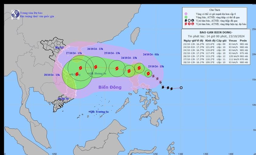
Latest update on storm TRAMI: Storm TRAMI is moving quickly in the West-Northwest direction, likely to head straight into the central coast. Photo: NCHMF
It is forecasted that around October 24, storm Tra Mi will enter the East Sea and become the 6th storm active in the East Sea in 2024. It will then likely make landfall in the Central provinces, causing long-term heavy rain in the region.
Forecast of location and path of storm TRAMI in the next 24 to 72 hours
Forecast time | Direction, speed | Location | Intensity | Danger zone | Disaster Risk Level (Affected Area) |
13h/24/10 | Northwest later it is possible to change direction West Southwest , 15-20km/h, entering the East Sea | 16.7N-119.8E; in the eastern sea of the North East Sea area | Level 9, jerk level 11 | Latitude 14.0N-19.5N; East of longitude 117.5E | Level 3: East of the North East Sea area |
13h/25/10 | West Northwest, 10-15km/h | 17.2N-117.4E; in the eastern sea of the North East Sea, 640km east of Hoang Sa archipelago | Level 10, jerk level 12 | Latitude 14.5N-20.0N; East of longitude 115.0E | Level 3: East of the North East Sea area |
13h/26/10 | West, 15-20km/h | 17.5N-113.2E; in the northeastern sea of Hoang Sa archipelago | Level 12, jerk level 15 | Latitude 15.0N-20.0N; East of longitude 110.5E | Level 3: North East Sea area |
From the next 72 to 120 hours, storm TRAMI will move mainly in a westerly direction, about 15 km per hour , then likely change direction to the South Southwest and move more slowly.
Forecast of impact of storm TRAMI
The East Sea area of the North East Sea has strong winds of level 6-7. From early morning on October 24, it will increase to level 8 (62-74km/h), near the storm center it will be level 9-10 (75-102km/h), gusting to level 12, waves 3.0-5.0m high, near the storm center 5.0-7.0m; very rough seas.
Ships operating in the above mentioned dangerous areas are likely to be affected by storms, whirlwinds, strong winds and large waves.
According to forecasts by hydrometeorological experts, heavy rains may begin from October 27 to October 31 in the North Central region. After that, the remnants of storm Tra Mi may form a low pressure area in the central coastal region and continue to cause heavy rains from November 1 to November 5 over a fairly wide area, including the coastal provinces of the Central region and the Central Highlands. It is necessary to be vigilant against widespread flooding and accompanying natural disasters such as flash floods and landslides in the mountainous regions of the Central region.
Responding to storm Tra Mi, the Ministry of Agriculture and Rural Development continues to send official dispatches to the People's Committees of coastal provinces and cities from Quang Ninh to Binh Dinh.
To proactively respond to heavy rain and tropical depressions, the Minister of Agriculture and Rural Development requested ministries, branches, and Chairmen of People's Committees of coastal provinces and cities from Quang Ninh to Binh Dinh to closely monitor forecasts and warnings; notify captains and owners of vehicles and boats (including tourist boats) operating at sea to proactively prevent and have appropriate production plans, ensuring safety of people and property; maintain communication to promptly handle bad situations that may occur. Prepare forces and means for rescue when requested.
Deploy shock forces to inspect and review residential areas along rivers, streams, low-lying areas, and areas at high risk of flooding, flash floods, and landslides; proactively evacuate people in dangerous areas to safe places.
Organize forces to guard, control, and guide traffic safety for people and vehicles, especially at culverts, spillways, deep flooded areas, areas with strong currents, areas where landslides have occurred or are at risk of landslides; arrange forces, materials, and means to overcome incidents, and ensure smooth traffic on main traffic routes.
Organize operations and implement plans to ensure safety of reservoirs and downstream areas, especially small hydropower reservoirs, important irrigation reservoirs, and projects under construction; arrange permanent forces to operate and regulate and be ready to handle possible situations.
Direct local radio and television stations and mass media agencies to strengthen measures to inform authorities and people about weather and natural disaster developments so that they can proactively prevent and respond.
On duty seriously (24/24h), regularly reporting to the Ministry of Agriculture and Rural Development (through the Department of Dyke Management and Disaster Prevention and Control).
Source: https://danviet.vn/cap-nhat-tin-bao-trami-moi-nhat-bao-di-nhanh-theo-huong-tay-tay-bac-tien-thang-vao-bien-mien-trung-20241023142346038.htm


Comment (0)