
According to the latest storm bulletin, Super Typhoon Man-yi is currently at level 16 (184-201 km/h), with gusts exceeding level 17, moving northwest at a speed of 20 km/h.
According to the National Center for Hydro-Meteorological Forecasting, at 7:00 AM on November 17th, the center of Super Typhoon Man-yi was located at approximately 14.9 degrees North latitude and 123 degrees East longitude, in the sea east of the central Philippines.
The strongest winds near the center of the super typhoon reached level 16 (184-201 km/h), with gusts exceeding level 17. The super typhoon is moving northwest at a speed of 20 km/h.
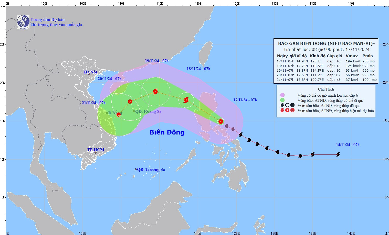
The meteorological agency forecasts the storm's development over the next 24-72 hours as follows:
| Forecast time | Direction, speed | Location | Intensity | Hazardous area | Level of natural disaster risk (Affected area) |
|---|---|---|---|---|---|
| 7am/November 18th | Northwest, at about 20-25 km/h, it entered the South China Sea and gradually weakened. | 17.7N-118.5E; in the eastern part of the North East Sea region. | Level 12, then level 15 | Latitude 14.0N-19.0N; East of longitude 118.0E | Level 3: East of the North South China Sea region |
| 7am/November 19 | Northwest, 20-25km/h, continues to weaken. | 18.8N-114.5E; in the northern South China Sea; approximately 410km northeast of the Paracel Islands. | Level 10, then level 13 | Latitude 15.0N-21.0N; East of longitude 113.5E | Level 3: Northern South China Sea region |
| 7am/November 20th | Southwesterly speed of approximately 15 km/h, gradually weakening into a tropical depression. | 17.5N-111.2E; in the northern South China Sea, approximately 160km north-northwest of the Paracel Islands. | Level 7, bursts up to level 9. | Latitude 15.0N-20.5N; Longitude 109.5E-117.5E | Level 3: Western part of the North East Sea region |
Over the next 72-96 hours, the tropical depression will move in a south-southwest direction at a speed of 10 km per hour, and its intensity will continue to weaken.
Super Typhoon Man-yi caused strong winds and high waves at sea.
From the afternoon of November 17th, the eastern part of the North East Sea experienced strong winds of force 6-7, later increasing to force 8-9, reaching force 10-12 near the storm's center, with gusts up to force 15; sea waves were 2-4m high, and 5-7m near the storm's center; the sea was extremely rough.
Vessels operating in the aforementioned hazardous areas are susceptible to the effects of thunderstorms, tornadoes, strong winds, and high waves.
Source: https://vietnamnet.vn/tin-moi-sieu-bao-man-yi-du-doi-gan-bien-dong-2342779.html


![[Photo] General Secretary and President To Lam presides over a meeting on preparations for the review of one year of operation of the three-tiered government system.](https://vphoto.vietnam.vn/thumb/1200x675/vietnam/resource/IMAGE/2026/06/02/1780391821195_a1-bnd-4595-9717-jpg.webp)


Comment (0)