
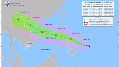
Latest storm news: According to the National Center for Hydro-Meteorological Forecasting, at 7:00 a.m. on November 18, the center of the storm was at about 18.2 degrees North latitude; 118.3 degrees East longitude, in the eastern sea of the North East Sea area.
Current status of storm No. 9
At 7:00 a.m. on November 18, the center of the storm was at about 18.2 degrees North latitude; 118.3 degrees East longitude, in the eastern sea of the North East Sea. The strongest wind near the center of the storm was level 11 (103-117 km/h), gusting to level 14. Moving in the West Northwest direction, speed about 20 km/h.

Latest news on storm number 9: Detailed forecast on the intensity and direction of storm number 9, cold air is moving slowly
Forecast of storm No. 9 in the next 24 to 72 hours:
Forecast of impact of storm No. 9: The eastern sea area of the North East Sea has strong winds of level 8-9, the area near the storm's eye has winds of level 10-11, gusts of level 14, waves 3.0-5.0m high, the area near the storm's eye has waves of 5.0-7.0m; the sea is very rough.Vessels operating in the above mentioned dangerous areas are susceptible to the impact of storms, whirlwinds, strong winds and large waves.
Cold air forecast
Cold air developments in the past 24 hours: Currently (November 18), the reported cold air mass is still moving south.
On land: around November 18, this cold air mass will affect some places in the Northeast region of the North; then affect other places in the Northeast and North Central regions, some places in the Northwest and North Central regions. Northeast wind inland level 2-3, coastal areas level 3-4.
From the night of November 18, in the Northeast and Thanh Hoa, the weather will turn cold at night and early morning; from November 20, in the North and North Central regions, the weather will be cold at night and early morning. The lowest temperature during this cold air mass in the North and North Central regions will generally be from 18-20 degrees Celsius, in mountainous areas, some places will be below 15 degrees Celsius.
At sea: in the Gulf of Tonkin from the night of November 18, there will be strong northeast winds at level 6, gusting to level 7-8; rough seas; waves 2.0-3.5m high.
In the North East Sea area, the Northeast wind (including the sea area of Hoang Sa archipelago) is strong at level 6-7, gusting at level 8-9; rough seas; waves are 2.0-4.0m high.
Detailed forecast:
Due to the influence of disturbances in the upper easterly wind zone combined with cold air, from November 18-19 in the North and Central Central regions there will be rain, showers and thunderstorms in some places, locally heavy rain in some places.
Thunderstorms may produce tornadoes, lightning and strong gusts of wind.
Thunderstorms accompanied by tornadoes, lightning and strong gusts of wind can affect agricultural production, cause trees to fall, damage houses, traffic works and infrastructure.
Localized heavy rains are likely to cause flooding in low-lying areas; flash floods in small rivers and streams, and landslides on steep slopes.
Strong winds and large waves at sea are likely to affect boat operations and other activities.
Source: https://danviet.vn/nong-du-bao-chi-tiet-ve-cuong-do-va-huong-di-cua-bao-so-9-khong-khi-lanh-dang-di-chuyen-cham-20241118085407755.htm
![[Photo] Ca Mau "struggling" to cope with the highest tide of the year, forecast to exceed alert level 3](https://vphoto.vietnam.vn/thumb/1200x675/vietnam/resource/IMAGE/2025/11/04/1762235371445_ndo_br_trieu-cuong-2-6486-jpg.webp)


![[Photo] Ho Chi Minh City Youth Take Action for a Cleaner Environment](https://vphoto.vietnam.vn/thumb/1200x675/vietnam/resource/IMAGE/2025/11/04/1762233574890_550816358-1108586934787014-6430522970717297480-n-1-jpg.webp)
![[Photo] Panorama of the Patriotic Emulation Congress of Nhan Dan Newspaper for the period 2025-2030](https://vphoto.vietnam.vn/thumb/1200x675/vietnam/resource/IMAGE/2025/11/04/1762252775462_ndo_br_dhthiduayeuncbaond-6125-jpg.webp)
![[Photo] The road connecting Dong Nai with Ho Chi Minh City is still unfinished after 5 years of construction.](https://vphoto.vietnam.vn/thumb/1200x675/vietnam/resource/IMAGE/2025/11/04/1762241675985_ndo_br_dji-20251104104418-0635-d-resize-1295-jpg.webp)


![Veterinary vaccine story: [Part 1] Trust from healthy ducks](https://vphoto.vietnam.vn/thumb/402x226/vietnam/resource/IMAGE/2025/11/04/1762242604682_0249-dsc09461-145316_229.jpeg)


Comment (0)