
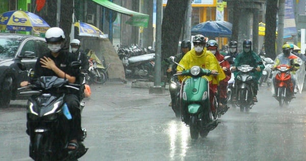
TPO - The Meteorological Agency forecasts that Ho Chi Minh City and the Southern region will continue to have scattered showers and thunderstorms in the afternoon and evening in the last days of June. Thunderstorms may include tornadoes, lightning, hail and strong gusts of wind.
According to the National Center for Hydro-Meteorological Forecasting, last night and early this morning (June 23), the Southern region had moderate rain, locally heavy to very heavy rain.
It is forecasted that today and tonight (June 23), the Southern region will have moderate rain, heavy rain and thunderstorms, locally very heavy rain with common rainfall from 30 - 60mm, some places over 120mm. Heavy rain will mainly be concentrated in the afternoon and at night. From June 24, heavy rain in the Central Highlands and the Southern region is likely to gradually decrease.
From the night of June 24 to July 2, the Southern region will continue to have scattered showers and thunderstorms in the afternoon and evening. Thunderstorms may include tornadoes, lightning, hail and strong gusts of wind.
 |
The Meteorological Agency forecasts that Ho Chi Minh City and the Southern region will continue to have scattered showers and thunderstorms in the afternoon and evening in the last days of June. (Illustration: Pham Nguyen) |
Forecasting the weather in Ho Chi Minh City in the last days of June, the Southern Hydrometeorological Station said that in the next 24 hours, the subtropical high pressure over the Central region will weaken and slowly recede to the East, forming a high-altitude wind convergence zone in the Southern region. The low pressure trough with an axis passing through the South Central region tends to gradually lift its axis to the North, combined with the Southwest monsoon that tends to gradually become stronger.
In the last days of June, the low pressure trough with its axis passing through the Central Central region connects with the low pressure area in the middle of the East Sea, gradually lifting its axis to the North and is likely to become stronger. The southwest monsoon operates with moderate to strong intensity. Above, the subtropical high pressure has a stable intensity, then encroaches back to the West and lifts its axis to the North, weakens in the last 2-3 days and slowly recedes to the East.
Based on the above weather patterns, the Southern Hydrometeorological Station forecasts that Ho Chi Minh City will continue to have rain in the last days of June. Thunderstorms will appear mainly in the late afternoon and evening.
“Thunderstorms may cause tornadoes, lightning, hail, and strong gusts of wind. Beware of heavy rain causing localized flooding,” the Southern Hydrometeorological Station advised.
Strong winds and big waves at sea
According to the National Center for Hydro-Meteorological Forecasting, in the past 24 hours, at Phu Quy island station (Binh Thuan), there has been strong southwest wind of level 6, sometimes level 7, gusting to level 9.
Forecast for today and tonight (June 23), in the area between the East Sea and the South East Sea (including the waters of the Hoang Sa and Truong Sa archipelagos), the waters from Quang Ngai to Ca Mau, Ca Mau to Kien Giang and the Gulf of Thailand, there will be showers and strong thunderstorms. During thunderstorms, there is a possibility of tornadoes and strong gusts of wind (level 7 - 8), be careful of wave heights sometimes increasing to over 2.5m.
All vessels operating in the above areas are at high risk of being affected by tornadoes, strong winds and large waves.


Source: https://tienphong.vn/luu-y-thoi-tiet-tphcm-va-nam-bo-nhung-ngay-cuoi-thang-6-post1648667.tpo


![[Photo] Overcoming all difficulties, speeding up construction progress of Hoa Binh Hydropower Plant Expansion Project](https://vstatic.vietnam.vn/vietnam/resource/IMAGE/2025/4/12/bff04b551e98484c84d74c8faa3526e0)


![[Photo] Closing of the 11th Conference of the 13th Central Committee of the Communist Party of Vietnam](https://vstatic.vietnam.vn/vietnam/resource/IMAGE/2025/4/12/114b57fe6e9b4814a5ddfacf6dfe5b7f)


Comment (0)