
The first full-size 3D image scan of the Titanic, located 3,800m below the Atlantic Ocean, was created using deep-sea mapping, according to the BBC .
The scans provide a 3D view of the entire ship on the seabed, which scientists hope will shed more light on what happened to the ship in 1912.
Until now, most theories have suggested that the Titanic crashed when it hit an iceberg in the Atlantic Ocean on its journey from Southampton (England) to New York (USA). More than 1,500 people died when the ship sank.
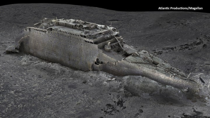
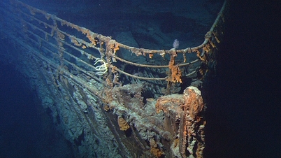
The current state of the Titanic wreck after more than 100 years at the bottom of the ocean (Photo: Magella/Atlantic Productions).
"There are still questions to be answered about the Titanic disaster," Parks Stephenson, an expert on the Titanic sinking, told the BBC . He said the 3D image was "one of the first important steps in moving the Titanic story towards evidence-based research - not speculation."
The Titanic wreck became the subject of much exploration when it was discovered in 1985. However, the ship was so large and the sea in which it sank was so deep that recent images only give a glimpse of the Titanic's condition after 111 years.
The 3D scan provides a panoramic view of the Titanic. The wreck is in two parts: the bow and stern are about 800m apart. A gap with huge pieces of debris surrounds the broken ship.
The 3D scan of the Titanic was carried out in the summer of 2022 by Magellan Ltd - a company specializing in deep-sea mapping - and Atlantic Productions, which is making a documentary about the project.
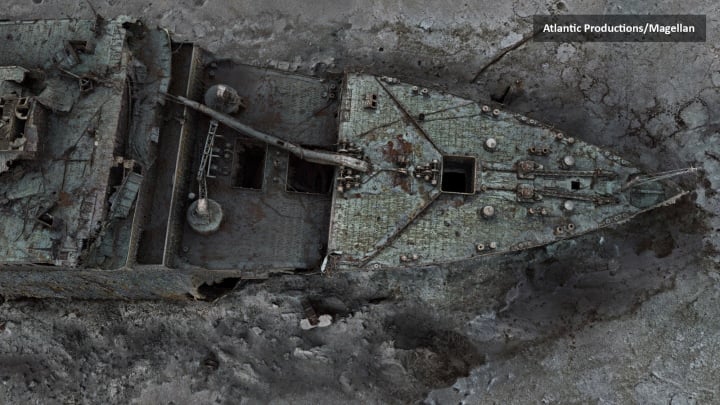
Never before have photographs shown the Titanic wreck in such detail as these newly released images (Photo: Magella/Atlantic Productions).
Remotely operated submersibles operated by a dedicated onboard team spent more than 200 hours surveying the length and breadth of the wreck, taking more than 700,000 images from every angle, creating an accurate 3D reconstruction.
According to expert Gerhard Seiffert - head of the 3D scanning project of the Titanic by Magellan, this is the largest underwater 3D scanning project he has ever done.
"The location of the ship is at a depth of almost 4,000 m and that is the challenge, there are currents at this location and we are not allowed to touch anything so as not to damage the wreck," Mr Seiffert explained.
“The other challenge is that you have to map every square centimeter – even the uninteresting parts, like on the debris field, you have to map the mud, but this is to fill the entire wreck site,” added Mr Seiffert.
Expert Parks Stephenson, who has studied the Titanic's surface for many years, said he was "stunned" when he first saw 3D scans of the ship.
"It allows you to see the whole wreck of the Titanic which you could never see from a submersible, this project allows us to determine the true condition of the ship," Stephenson said.
Studying the scans could provide new insight into what happened to the Titanic on that fateful night in 1912.
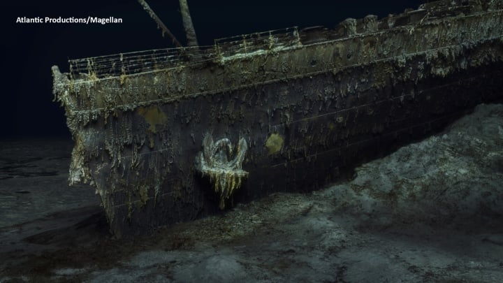
The bow of the Titanic, which sank in 1912, lies on the ocean floor (Photo: Magella/Atlantic Productions).
"We really don't know the details of the collision with the iceberg. We don't even know whether the ship struck it along the starboard side as has been suggested, or whether it may have struck the top of the iceberg," Mr Stephenson explained.
Studying the stern could reveal the mechanism of how the ship hit the seabed, he added.
It is hoped the scans can reveal more about what happened the night the Titanic went missing.
The sea is taking its toll on the wreck, bacteria is eating it away, and parts are decomposing. Historians clearly realize that time is running out to study the disaster.
The Titanic sank after hitting an iceberg in the early morning hours of April 15, 1912, during its maiden voyage from Southampton, England to New York City, USA. The tragedy resulted in the deaths of more than 1,500 passengers and continues to be a subject of interest to this day.
Thao Anh (Source: BBC)
Useful
Emotion
Creative
Unique
Source

![[Photo] Panorama of the Patriotic Emulation Congress of Nhan Dan Newspaper for the period 2025-2030](https://vphoto.vietnam.vn/thumb/1200x675/vietnam/resource/IMAGE/2025/11/04/1762252775462_ndo_br_dhthiduayeuncbaond-6125-jpg.webp)

![[Photo] Ca Mau "struggling" to cope with the highest tide of the year, forecast to exceed alert level 3](https://vphoto.vietnam.vn/thumb/1200x675/vietnam/resource/IMAGE/2025/11/04/1762235371445_ndo_br_trieu-cuong-2-6486-jpg.webp)
![[Photo] The road connecting Dong Nai with Ho Chi Minh City is still unfinished after 5 years of construction.](https://vphoto.vietnam.vn/thumb/1200x675/vietnam/resource/IMAGE/2025/11/04/1762241675985_ndo_br_dji-20251104104418-0635-d-resize-1295-jpg.webp)
![[Photo] Ho Chi Minh City Youth Take Action for a Cleaner Environment](https://vphoto.vietnam.vn/thumb/1200x675/vietnam/resource/IMAGE/2025/11/04/1762233574890_550816358-1108586934787014-6430522970717297480-n-1-jpg.webp)


Comment (0)