

Tropical depression causes heavy rain and thunderstorms, with the possibility of tornadoes and strong gusts of wind, affecting ships in the Gulf of Tonkin.
The National Center for Hydro-Meteorological Forecasting said that at 1:00 p.m. (June 9), the low pressure area in the northern part of the Gulf of Tonkin was located at about 21.0-22.0 degrees North latitude; 108.0-109.0 degrees East longitude.
It is forecasted that in the next 24 hours, the low pressure area will continue to move slowly and may strengthen into a tropical depression.
Impact warning, there are strong thunderstorms in the Gulf of Tonkin. During the thunderstorms, there is a possibility of tornadoes and strong gusts of wind level 6-7, affecting ships operating in the Gulf of Tonkin area.
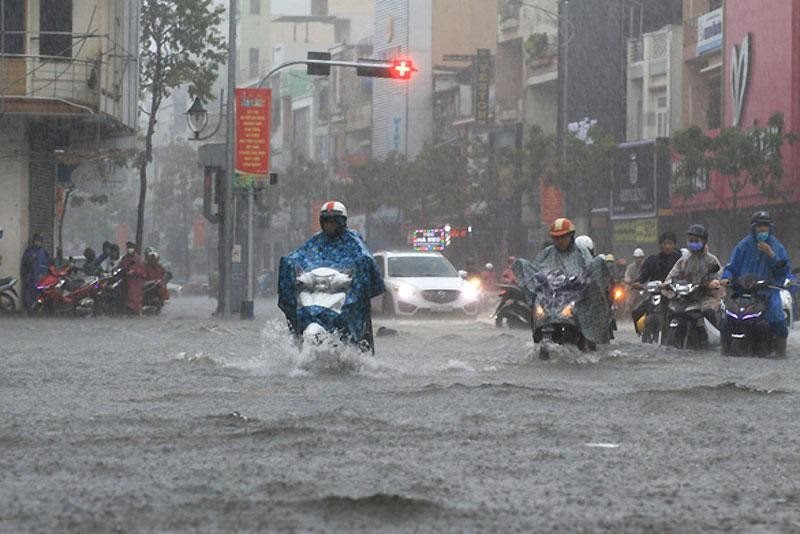
Moderate rain, heavy rain and strong thunderstorms, strong gusts of wind are likely to occur in the coastal provinces of the Northeast.
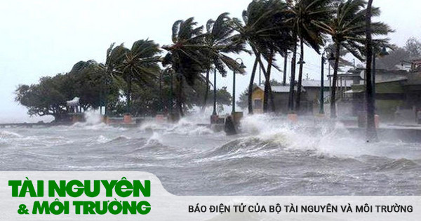
In addition, due to the influence of the southwest monsoon with medium to strong intensity, during the night of June 9 and June 10, in the sea area from Binh Thuan to Ca Mau, Ca Mau to Kien Giang, the Gulf of Thailand and the East Sea (including the sea area of Hoang Sa and Truong Sa archipelagos), there will be showers and strong thunderstorms. During the thunderstorms, there is a possibility of tornadoes and strong gusts of wind of level 6-7.
During the night of June 9 and June 10, in the sea area from Khanh Hoa to Ca Mau and the southwestern sea area of the central East Sea, there will be strong southwest winds of level 5, sometimes level 6, gusting to level 7; waves from 2.0-3.5m high; rough seas.
Heavy rain forecast
From the evening of June 8 to the morning of June 9, in the Northern region and Thanh Hoa, Nghe An, there was moderate rain, heavy rain, and some places had very heavy rain; the rainfall from 7:00 p.m. on June 8 to 8:00 a.m. on June 9 was generally from 40-100mm, some places over 100mm such as: Muong Sai (Son La) 156.4mm, Dong Bac (Hoa Binh) 135.2mm, Minh Quang (Vinh Phuc) 195.3mm, Phuc Son (Yen Bai) 114.0mm, Son Tay (Hanoi) 101mm, Trung Ly (Thanh Hoa) 137.6mm, Quy Chau (Nghe An) 168.8mm, ...
From the afternoon of June 9 to 11, in the Central Highlands and the South, there will be moderate rain, some places will have heavy to very heavy rain with common rainfall from 40-90mm, some places over 130mm (rain concentrated in the afternoon and evening).
| Area | Time of impact | Total volume (mm) |
| Northern Region, Thanh Hoa | From 07:00 - 19:00/09/06 | 20-40mm, some places over 60mm |
| Central Highlands and South | From 13:00/09/6-07:00/06/10 | 15-30mm, some places over 50mm |
| Central Highlands and South | From 07:00/10/6-19:00/11/6 | 20-50mm, some places over 80mm |
Warning: Thunderstorms and localized heavy rain in the Central Highlands and the South are likely to last until around June 13 (rain concentrated in the afternoon and evening). Beware of the risk of flash floods and landslides in mountainous areas and flooding in low-lying areas. Thunderstorms may cause tornadoes, lightning, hail and strong gusts of wind.
Proactively respond to heavy rain and the risk of flash floods and landslides in mountainous districts of Thanh Hoa
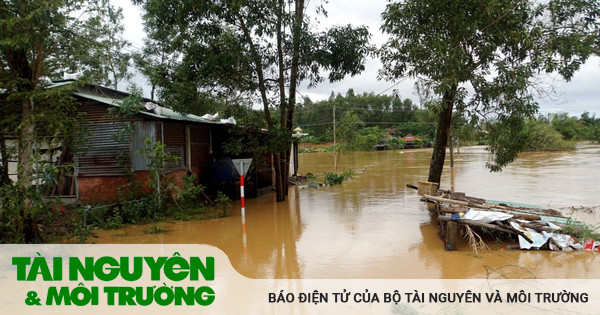
On the morning of June 9, according to information from the Thanh Hoa Hydrometeorological Station, there will continue to be rain in the province, with some areas experiencing moderate to heavy rain; there is a risk of flash floods, landslides, and land subsidence in mountainous districts.
Total rainfall from 7:00 p.m. on June 8 to 9:00 a.m. on June 9 at hydrometeorological stations was generally 30 - 80 mm. Some automatic rain gauges had larger rainfall such as: Lang Chanh 125.6 mm, Thiet Ke (Ba Thuoc) 125.4 mm, Trung Ly (Muong Lat) 121.2 mm, Na Meo commune (Quan Son) 104 mm...
It is forecasted that from June 11-13, Thanh Hoa will continue to have rain, moderate rain with common rainfall from 30 - 150 mm. Thunderstorms accompanied by whirlwinds, lightning, hail and strong gusts of wind can affect agricultural production, break trees, damage houses, traffic works and infrastructure.
In particular, the mountainous districts of Ba Thuoc, Lang Chanh, Quan Son, Quan Hoa, Cam Thuy, Thach Thanh, Muong Lat, Ngoc Lac, Thuong Xuan, and Nhu Xuan are at risk of flash floods, landslides, and land subsidence.
To proactively respond to the low pressure area that may strengthen into a tropical depression, the Steering Committee for Natural Disaster Prevention, Search and Rescue and Civil Defense of Thanh Hoa province has issued a document requesting the Steering Committee for Natural Disaster Prevention, Search and Rescue and Civil Defense of districts, towns, cities, departments, branches and related units to closely monitor warning and forecast bulletins, promptly provide information to authorities at all levels and people to proactively prevent and minimize damage.
Units closely monitor information and developments of low pressure areas that are likely to strengthen into tropical depressions; organize a count of vessels operating in the Gulf of Tonkin, strictly manage offshore vessels, notify owners of vessels and captains of vessels operating at sea of the location, direction of movement and developments of low pressure areas to proactively prevent and adjust production plans accordingly.
In addition, units have increased inspection and review of residential areas along rivers, streams, dykes, dams, low-lying areas, and areas at high risk of flooding, flash floods, and landslides to proactively organize the relocation and evacuation of people when situations arise; clear the flow, and promptly handle construction incidents from the first hour.

Closely control ships going out to sea, prepare rescue forces and equipment when there is a situation.
The Standing Office of the National Steering Committee for Natural Disaster Prevention and Control has issued a document requesting localities from Quang Ninh to Quang Binh, the Border Guard Command, and the Department of Fisheries and Fisheries to proactively respond to low pressure areas that may strengthen into tropical depressions.
The document clearly states that, in order to proactively respond to low pressure areas that are likely to strengthen into tropical depressions, and avoid serious human losses at sea like the 1996 tropical depression in the Gulf of Tonkin; the Standing Office of the National Steering Committee for Natural Disaster Prevention and Control has issued Document No. 204/VPTT dated June 8, 2023 to coastal provinces and cities from Quang Ninh to Quang Binh.
The Standing Office requested the Border Guard Command, the Steering Committee for Natural Disaster Prevention and Search and Rescue of provinces and cities and relevant agencies and units to closely monitor information and developments of the low pressure area that is likely to strengthen into a tropical depression.
Organize the counting of vessels operating in the Gulf of Tonkin, strictly manage offshore vessels, notify owners of vessels and captains of vessels operating at sea of the location, direction of movement and developments of low pressure areas to proactively prevent and adjust production plans accordingly.
Prepare forces and means to deploy rescue work when there is a situation.
Vietnam Television, Voice of Vietnam, Vietnam News Agency, Coastal Information Station and mass media agencies should increase information about the developments of the low pressure area to authorities at all levels, owners of vehicles operating at sea and people to proactively prevent and respond.
Be on duty seriously and regularly report to the Standing Office of the National Steering Committee for Natural Disaster Prevention and Control and the Office of the National Committee for Incident Response, Natural Disasters and Search and Rescue./.
Source


Comment (0)