
According to the National Center for Hydro-Meteorological Forecasting, currently, due to the influence of the circulation of storm No. 6 (storm Tra Mi), Con Co Island (Quang Tri) has strong winds of level 8, gusting to level 9; Cu Lao Cham Island (Quang Nam) has strong winds of level 8, gusting to level 10; Ly Son Island (Quang Ngai) has level 6, gusting to level 7; Nam Dong (Thua Thien Hue) has strong winds of level 7; Thua Thien Hue has strong winds of level 6, gusting to level 8; Ba Na (Da Nang) has strong winds of level 6, gusting to level 13.
The area from Quang Binh to Da Nang has had heavy rain, with rainfall ranging from 50-150mm, with some places experiencing heavy rain over 250mm.
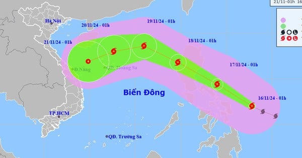
At 7:00 a.m. on October 27, the center of the storm was at approximately 16.8 degrees North latitude; 108.6 degrees East longitude, on the sea from Quang Tri to Quang Nam. The strongest wind near the center of the storm was level 9-10 (75-102 km/h), gusting to level 12. Moving westward at a speed of 15-20 km/h.
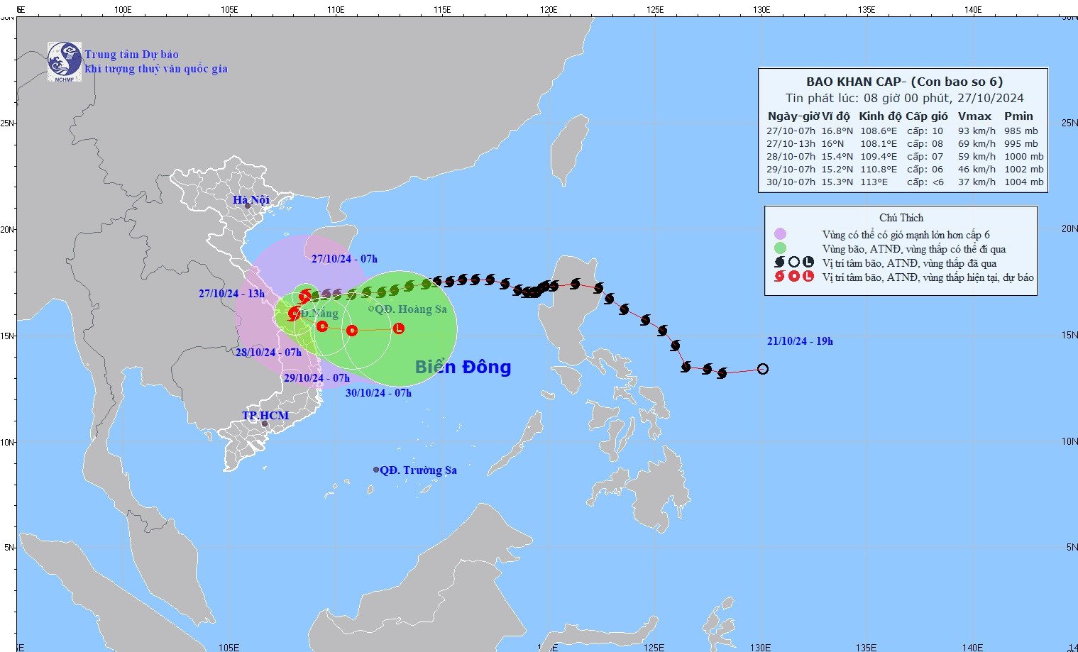
The Meteorological Agency predicts that after making landfall in the Central region today, storm No. 6 will move out to sea. Forecast for the storm in the next 24-72 hours:
| Forecast time | Direction, speed | Location | Intensity | Danger zone | Disaster Risk Level (Affected Area) |
|---|---|---|---|---|---|
| 07h/28/10 | Southwest then turns East Southeast, 5-10km/h, weakens into a tropical depression | 15.4N-109.4E; on the coastal waters of Central Central Vietnam | Level 6-7, level 9 jerk | Latitude 14.5N-19.5N; West of Longitude 111.5E | Level 3: West of the North East Sea area (including the sea area west of Hoang Sa archipelago), Central Central Coast sea area; coastal mainland of Quang Tri-Quang Ngai area |
| 07h/29/10 | East, 5-10km/h | 15.2N-110.8E; in the sea off the Central Central Coast | Level 6, level 8 jerk | Latitude 14.5N-19.0N; West of longitude 112.0E | Level 3: West of the North and Central East Sea (including the sea west of Hoang Sa archipelago), Central Central Coast sea |
| 07:30/10 | East, about 10km/h, weakening into a low pressure area | 15.3N-113.0E; in the sea southeast of Hoang Sa archipelago |
Forecast of impact of storm no. 6
The western sea area of the North East Sea has strong winds of level 6-7, sometimes level 8 on the morning of October 27, gusting to level 10, waves 2.0-4.0m high; rough seas.
The sea area of provinces from Quang Binh to Quang Ngai (including Con Co Island, Cu Lao Cham, Ly Son) has strong winds of level 6-7, the area near the storm's eye has winds of level 8-10, gusts of level 12, waves 3.0-5.0m high; very rough seas.
Storm surge in coastal areas: from the morning of October 27, coastal areas from Quang Binh to Quang Nam provinces are likely to experience storm surges of 0.4-0.6m high.
Ships operating in the above-mentioned dangerous areas (especially in the Hoang Sa island district), coastal areas from Quang Binh to Quang Ngai are likely to be affected by storms, whirlwinds, strong winds, and big waves.
High risk of landslides of sea dikes and embankments along the coast of provinces from Quang Tri to Quang Nam due to the impact of big waves and storm surges.
On land from Quang Binh to Quang Ngai, winds will gradually increase to level 6-7, gusting to level 8-9; near the storm center, winds will increase to level 8-9, gusting to level 11.
In addition, from October 27 to the night of October 28, in the area from Quang Binh to Quang Nam, there will be heavy to very heavy rain with total rainfall ranging from 200-400mm, locally over 600mm. Warning of the risk of localized heavy rain (>100mm/3h).
Ha Tinh, Quang Ngai, Binh Dinh and the Northern Central Highlands have heavy rain, locally very heavy rain with total rainfall ranging from 100-180mm, in some places over 250mm.


![[Photo] Prime Minister Pham Minh Chinh chairs Government Conference with localities on economic growth](https://vstatic.vietnam.vn/vietnam/resource/IMAGE/2025/2/21/f34583484f2643a2a2b72168a0d64baa)


Comment (0)