

1. Hoang Lien Son province was merged from which 3 localities?
- A
Yen Bai - Lao Cai - Tuyen Quang
- B
Yen Bai - Lao Cai - Nghia Lo
According to Yen Bai Province Electronic Information Portal, on January 3, 1976, the three provinces of Yen Bai - Lao Cai - Nghia Lo merged into Hoang Lien Son province. The two districts of Bac Yen and Phu Yen (belonging to Nghia Lo) were transferred to Son La province.
When merged, Hoang Lien Son province has 4 towns: Yen Bai town (provincial capital), Cam Duong, Lao Cai, Nghia Lo and 16 districts: Bac Ha, Bao Thang, Bao Yen, Bat Xat, Luc Yen, Mu Cang Chai, Muong Khuong, Sa Pa, Simacai, Than Uyen, Tram Tau, Tran Yen, Van Ban, Van Chan, Van Yen, Yen Binh. - C
Yen Bai - Lao Cai - Lai Chau
- D
Yen Bai - Lao Cai - Phu Tho

2. In what year was Hoang Lien Son divided into 2 provinces?
- A
1991
On October 1, 1991, Hoang Lien Son province was divided into two provinces, Yen Bai and Lao Cai. Than Uyen, Van Ban and Bao Yen districts, formerly belonging to Yen Bai province, were transferred to Lao Cai province.
From the separation of the province to 1995, Yen Bai province had 8 administrative units including: Yen Bai town, districts: Luc Yen, Yen Binh, Tran Yen, Van Yen, Van Chan, Tram Tau, Mu Cang Chai. In 1995, Nghia Lo town was established, so the whole province had 9 administrative units.
In 2002, Yen Bai town was upgraded to a city and since then, Yen Bai province includes: Yen Bai city; Nghia Lo town; districts: Yen Binh, Luc Yen, Tran Yen, Van Yen, Van Chan, Tram Tau, Mu Cang Chai with 180 communes, wards and towns. - B
1992
- C
1993
- D
1994
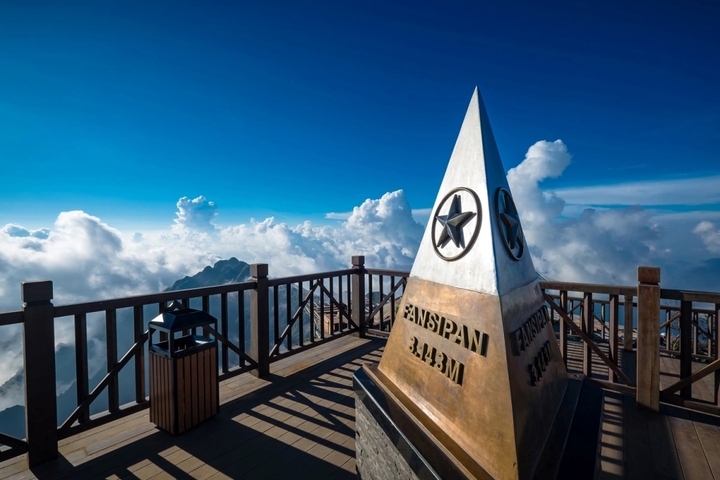
3. Which peak is the highest in Hoang Lien Son mountain range?
- A
Ta Lien Son
- B
Putaleng
- C
Pusilung
- D
Fansipan
Fansipan is the highest mountain in the Hoang Lien Son mountain range, located on the border of Lao Cai and Lai Chau provinces. Administratively, Fansipan peak belongs to both Tam Duong district (Lai Chau) and Sa Pa town (Lao Cai), about 9 km southwest of Sa Pa town center. The height of the mountain peak measured in 1909 was 3,143 m, however, according to the latest data from the Department of Surveying, Mapping and Geographic Information of Vietnam released at the end of June 2019, the mountain peak is 3,147.3 m high.
4. Which national park was established to protect the Hoang Lien Son ecosystem?
- A
Ba Be National Park
- B
Pu Mat National Park
- C
Hoang Lien National Park
Hoang Lien National Park is one of the important special-use forests of Vietnam with a total core area of 29,845 hectares, including the high mountain system of Hoang Lien Son range, of which Fansipan peak is 3,143m high and the buffer area is 38,724 hectares, including Sa Pa town, some communes of Sa Pa district, part of Van Ban district, Lao Cai province and 2 communes of Than Uyen district, Lai Chau province.
- D
Xuan Son National Park

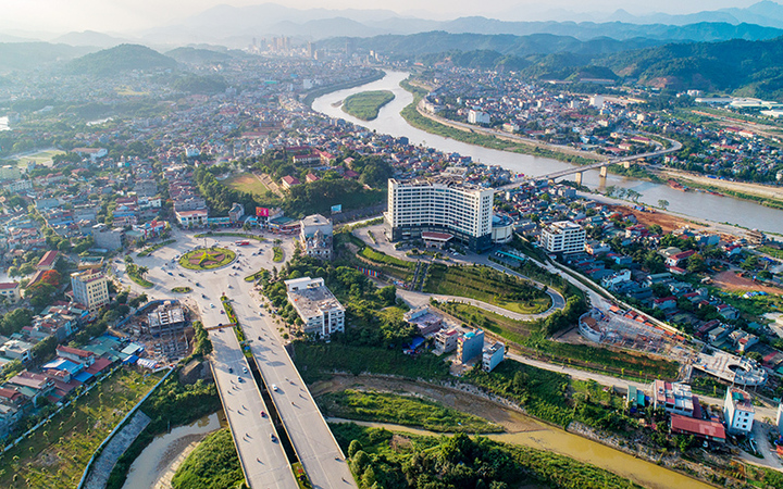
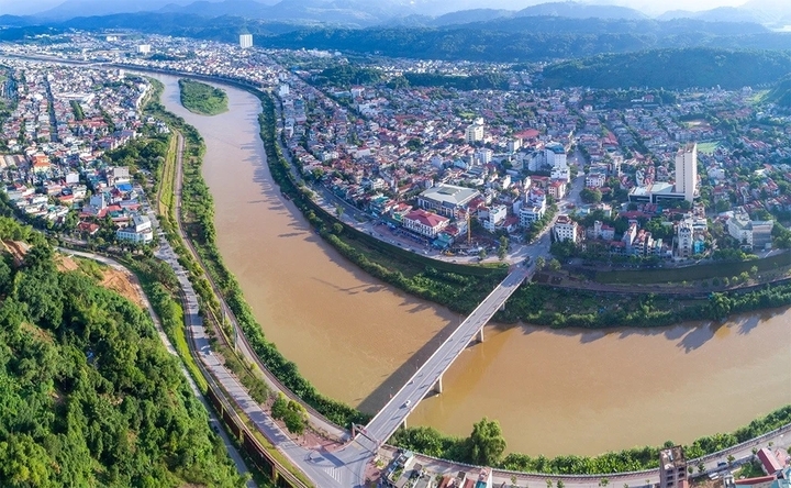
5. Which river flows through both Lao Cai and Yen Bai?
- A
Da River
- B
Day River
- C
Lo River
- D
Red River
In Lao Cai, the Red River is 73 m above sea level. In Yen Bai, the river is only 55 m high. Between the two provinces are 26 rapids and rapids. In Viet Tri, the river slope is not very steep anymore so the flow slows down. The Red River Delta is located downstream of this river.
The Red River has a very large average annual water flow, up to 2,640 m3/s (at the river mouth) with a total water flow of up to 83.5 billion m3, however the water flow is unevenly distributed. In the dry season, the flow decreases to only about 700 m3/s, but at the peak of the rainy season it can reach 30,000 m3/s.
Source: https://vtcnews.vn/tinh-hoang-lien-son-duoc-hop-nhat-tu-3-dia-phuong-nao-ar934604.html


![[Photo] Closing of the 11th Conference of the 13th Central Committee of the Communist Party of Vietnam](https://vstatic.vietnam.vn/vietnam/resource/IMAGE/2025/4/12/114b57fe6e9b4814a5ddfacf6dfe5b7f)

![[Photo] Overcoming all difficulties, speeding up construction progress of Hoa Binh Hydropower Plant Expansion Project](https://vstatic.vietnam.vn/vietnam/resource/IMAGE/2025/4/12/bff04b551e98484c84d74c8faa3526e0)


Comment (0)