
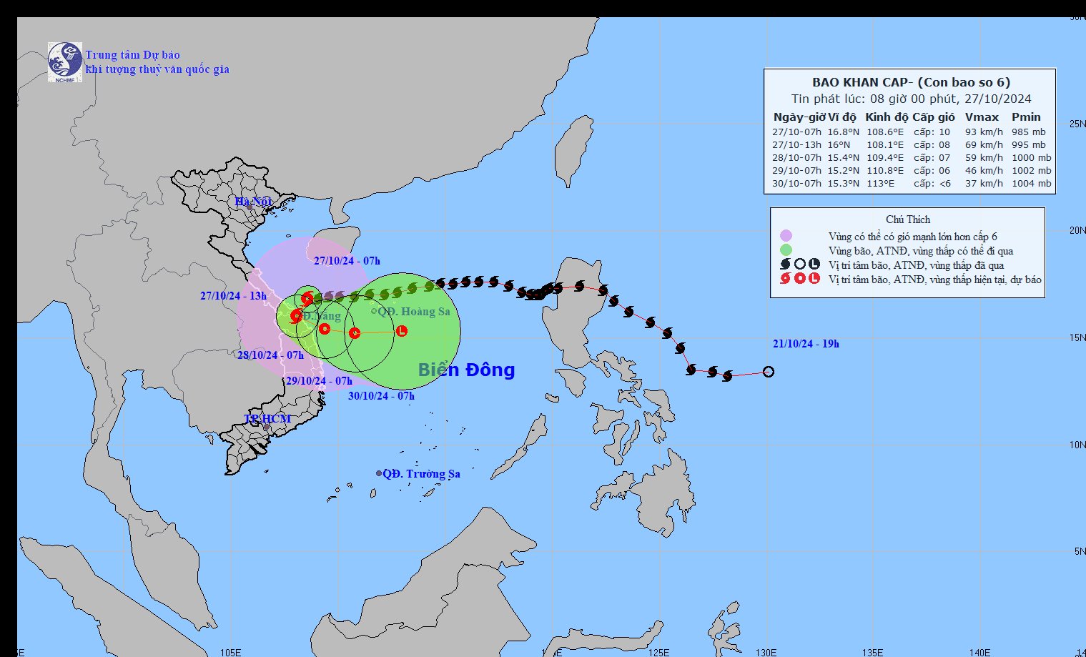
According to the National Center for Hydro-Meteorological Forecasting, the latest update on storm No. 6: At 7:00 a.m. on October 27, the center of the storm was at about 16.8 degrees North latitude; 108.6 degrees East longitude, on the sea area from Quang Tri to Quang Nam. The strongest impact is expected to occur around noon to this afternoon.
Latest news update on storm number 6: Currently in the sea area from Quang Tri to Quang Nam
At 7:00 a.m. on October 27, the center of the storm was at approximately 16.8 degrees North latitude; 108.6 degrees East longitude, on the sea from Quang Tri to Quang Nam. The strongest wind near the center of the storm was level 9-10 (75-102 km/h), gusting to level 12. Moving westward at a speed of 15-20 km/h.
Direction of movement of storm No. 6. Photo: nchmf.
Due to the influence of storm No. 6's circulation, Con Co Island (Quang Tri) has strong winds of level 8, gusting to level 9; Cu Lao Cham Island (Quang Nam) has strong winds of level 8, gusting to level 10; Ly Son Island (Quang Ngai) has level 6, gusting to level 7; Nam Dong (Thua Thien Hue) has strong winds of level 7; Thua Thien Hue has strong winds of level 6, gusting to level 8; Ba Na (Da Nang) has strong winds of level 6, gusting to level 13.
The area from Quang Binh to Da Nang has had heavy rain, with rainfall ranging from 50-150mm, with some places experiencing heavy rain over 250mm.
Forecast of storm No. 6 in the next 24 to 72 hours:
Forecast time | Direction, speed | Location | Intensity | Danger zone | Disaster Risk Level (Affected Area) |
07h/28/10 | Southwest then turns East Southeast, 5-10km/h, weakens into a tropical depression | 15.4N-109.4E; on the coastal waters of Central Central Vietnam | Level 6-7, level 9 jerk | Latitude 14.5N-19.5N; West of Longitude 111.5E | Level 3: West of the North East Sea area (including the sea area west of Hoang Sa archipelago), Central Central Coast sea area; coastal mainland of Quang Tri-Quang Ngai area |
07h/29/10 | East, 5-10km/h | 15.2N-110.8E; in the sea off the Central Central Coast | Level 6, level 8 jerk | Latitude 14.5N-19.0N; West of longitude 112.0E | Level 3: West of the North and Central East Sea (including the sea west of Hoang Sa archipelago), Central Central Coast sea |
07:30/10 | East, about 10km/h, weakening into a low pressure area | 15.3N-113.0E; in the sea southeast of Hoang Sa archipelago |
On the impact of storm number 6
At sea:
- The western sea area of the North East Sea has strong winds of level 6-7, on the morning of October 27, sometimes level 8, gusting to level 10, waves 2.0-4.0m high; rough seas.
- The sea area of provinces from Quang Binh to Quang Ngai (including Con Co Island, Cu Lao Cham, Ly Son) has strong winds of level 6-7, the area near the storm's eye has winds of level 8-10, gusts of level 12, waves 3.0-5.0m high; very rough seas.
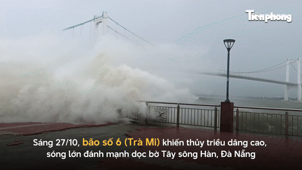
Storm surge in coastal areas: from the morning of October 27, coastal areas from Quang Binh to Quang Nam provinces are likely to experience storm surges of 0.4-0.6m high.
- Ships/boats operating in the above-mentioned dangerous areas (especially in the Hoang Sa island district), coastal areas from Quang Binh to Quang Ngai are all likely to be affected by storms, whirlwinds, strong winds, and big waves.
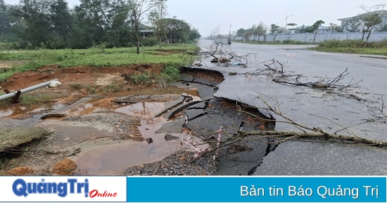
- High risk of landslides of sea dikes and embankments along the coast of provinces from Quang Tri to Quang Nam due to the impact of big waves and storm surges.
On land:
On land from Quang Binh to Quang Ngai, winds will gradually increase to level 6-7, gusting to level 8-9; near the storm center, winds will increase to level 8-9, gusting to level 11.
Heavy rain: From October 27 to the night of October 28, in the area from Quang Binh to Quang Nam, there will be heavy to very heavy rain with total rainfall from 200-400mm, locally over 600mm. Warning of the risk of local heavy rain (>100mm/3 hours). The areas of Ha Tinh, Quang Ngai, Binh Dinh and the Northern Central Highlands will have heavy rain, locally very heavy rain with total rainfall from 100-180mm, some places over 250mm.
When will storm number 6 have the strongest impact?

Mr. Mai Van Khiem, Director of the National Center for Hydro-Meteorological Forecasting - Photo: TT
According to the National Center for Hydro-Meteorological Forecasting, storm No. 6 has an unusual and unpredictable trajectory this storm season due to the influence of many weather patterns. It is expected to have the strongest impact from noon to this afternoon.
Sharing with Dan Viet, Mr. Mai Van Khiem - Director of the National Center for Hydro-Meteorological Forecasting warned about rain during and after the storm as follows:
"Today, we emphasize that the focus of rain is the areas from Quang Binh to Quang Nam with rainfall up to 100-200mm, locally it can be higher than 300mm. Second, today, storm No. 6 will make landfall and under those conditions it can cause heavy rain with rainfall in 3 hours up to about 100mm. In addition, the rainfall is not only today but can continue in the coming days, when the impact of cold air with the northern edge weakening into a tropical depression or low pressure area in the coming days".
"That is why the rainfall will continue in the coming days, not just today. With such a large area of rainfall lasting for many days, we emphasize: continuously warning of very high risks that need to be taken precautions. Firstly, flooding in low-lying areas and urban areas. Secondly, more seriously, there is a high to very high risk of flash floods and landslides in the western mountainous areas of the Central Central provinces. Especially the provinces from Ha Tinh, South Nghe An to Quang Nam, Quang Ngai and areas in Kon Tum, the Central Highlands.
We emphasize the risk of flash floods and landslides not only today when there is a direct impact of storm No. 6 but also in the following days, we need to be extremely cautious," Mr. Mai Van Khiem emphasized.
Flash flood and landslide warning in provinces from Ha Tinh to Quang Nam and Kon Tum
In the past 12 hours (from 7:00 p.m. on October 26 to 7:00 a.m. on October 27), the areas from Ha Tinh to Quang Nam and Kon Tum provinces have had moderate to very heavy rain such as: Kim Son Lake 93.6mm (Ha Tinh); Song Thai Lake 149mm (Quang Binh); La To Dam and Hydropower Plant 167.4mm (Quang Tri); Thuy Thanh 239.4mm (Thua Thien Hue); GD-DN Center 05-06 134.6mm (Da Nang); Phuoc Thanh 70.4mm (Quang Nam); Dak Choong 68.2mm (Kon Tum);...
Soil moisture models show that some areas in the above provinces are close to saturation (over 85%) or have reached saturation.
In the next 3-6 hours, the above provinces will continue to have rain with common accumulated rainfall as follows: Ha Tinh, Quang Binh and Kon Tum provinces will have rain from 10-20mm, some places over 70mm; provinces from Quang Tri to Quang Nam will have rain from 40-90mm, some places over 160mm; Thua Thien Hue alone will have rain from 50-100mm, some places over 180mm.
Warning of the impact of flash floods, landslides, and land subsidence due to heavy rain or water flow: Flash floods and landslides can have very negative impacts on the environment, threatening people's lives; causing local traffic congestion, affecting the movement of vehicles; destroying civil and economic works, causing damage to production and socio-economic activities.
Source: https://danviet.vn/khan-tin-moi-nhat-ve-bao-so-6-thoi-diem-nao-se-tac-dong-manh-nhat-den-nuoc-ta-20241027081156281.htm


![[Photo] Prime Minister Pham Minh Chinh chairs Government Conference with localities on economic growth](https://vstatic.vietnam.vn/vietnam/resource/IMAGE/2025/2/21/f34583484f2643a2a2b72168a0d64baa)


Comment (0)