
The railway line connecting the high-speed railway with Can Tho City, in the railway network planning for the period 2021 - 2030, with a vision to 2050, has a length of about 174 km, a gauge of 1435 mm, and an investment roadmap before 2030.
Ministry of Construction informs about high-speed railway connection with Can Tho City
The railway line connecting the high-speed railway with Can Tho City, in the railway network planning for the period 2021 - 2030, with a vision to 2050, has a length of about 174 km, a gauge of 1435 mm, and an investment roadmap before 2030.
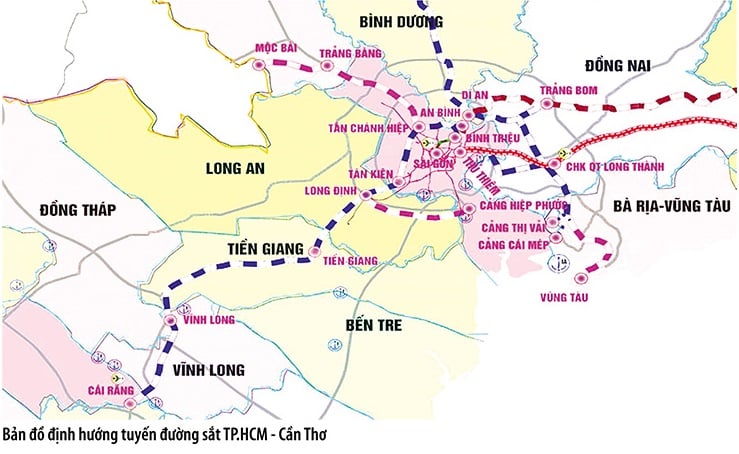 |
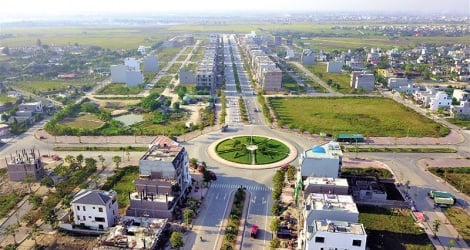
| Overview map of the Ho Chi Minh City - Can Tho railway route. |
This is the information given by Minister of Construction Tran Hong Minh in an official dispatch sent to the National Assembly Delegation of Can Tho City in response to the petition of local voters on the investment and synchronous connection of the high-speed railway project on the North-South axis with components to connect smoothly to major cities, including Can Tho City.
According to the Minister of Construction, the high-speed railway line on the North-South axis has been approved by the National Assembly in the investment policy in Resolution No. 172/2024/QH15 dated November 30, 2024, starting at Ngoc Hoi station (Hanoi), ending at Thu Thiem station (Ho Chi Minh City), with a length of 1,541 km, track gauge of 1,435 mm, expected to start construction in 2027, striving to be completed in 2035.
The Ministry of Construction agrees with the voters' recommendation that in order to maximize the effectiveness of investment in high-speed railways and form a planned railway network, it is necessary to research and invest in railways connecting to high-speed railways.
Currently, in the railway network planning, provincial planning for the period 2021-2030, and vision to 2050 of localities along the high-speed railway route, the development of urban railway lines connecting with high-speed railways has been basically oriented, the investment roadmap depends on transportation needs and the ability to mobilize resources.
Regarding the railway line connecting the high-speed railway with Can Tho City, in the railway network planning for the period 2021 - 2030, with a vision to 2050, the Ho Chi Minh City - Can Tho route has been planned to be about 174 km long, with a gauge of 1,435 mm, and an investment schedule before 2030.
“Currently, the Ministry of Construction is implementing the work of preparing a pre-feasibility study report to submit to competent authorities for approval of the investment policy, striving to complete synchronous exploitation with the North-South high-speed railway line,” said Minister Tran Hong Minh.
According to the Draft Pre-Feasibility Study Report of the Ho Chi Minh City - Can Tho railway line prepared by the TEDI SOUTH - TRICC - TEDI Consulting Joint Venture, the project will start at An Binh station in Di An ward, Di An city, Binh Duong province; end at Can Tho station in Phu Thu ward, Cai Rang district, Can Tho city. The route will pass through 6 provinces/cities, including Binh Duong, Ho Chi Minh City, Long An, Tien Giang, Vinh Long and Can Tho city.
TEDI SOUTH - TRICC - TEDI joint venture proposed that in the completion phase, the route will be built according to double-track standards with a gauge of 1,435 mm and electrification.
In which, phase I builds a single line from An Binh - Can Tho with a total route length of 175.2 km, including ground (length 76.6 km, accounting for 43.72%) and bridge works (viaduct, river crossing: length 98.6 km, accounting for 56.28%).
The route has a design speed of 120 km/h for freight trains; 160 km/h for passenger trains; using EMU distributed propulsion technology for passenger trains; and centralized propulsion technology for freight trains.
The route has an expected throughput capacity of about 26.148 million tons of cargo/year and 18.324 million passengers/year by 2055.
The route has 12 stations and 4 future passenger stations, 3 depots (An Binh, Tan Kien, Can Tho), 4 maintenance and vehicle inspection stations (Thanh Duc, Tam Hiep, Cai Lay, Binh Minh), 3 maintenance stations; infrastructure; 3 large river crossing locations (Sai Gon River, Dong Vam Co River, Tay Vam Co River) and 2 especially large river crossing locations (Tien River and Hau River).
The project carries out site clearance in accordance with the Railway Network Planning for the 2021-2030 period, with a vision to 2050, for a double-track gauge of 1,435 mm.
It is estimated that the land use demand of the entire Project is about 801.5 hectares, of which residential land is 193.88 hectares; agricultural land is about 479.1 hectares (of which rice land is about 430.19 hectares, other agricultural land is 48.92 hectares); other land (traffic construction land, public land...) is about 128.52 hectares.
With the above investment scale, the preliminary total investment of Phase I Project - construction of single road and overall site clearance is 173,643 billion VND, equivalent to 7.16 billion USD, of which the cost of compensation, support and resettlement according to the planning is about 45,675 billion VND (including volume contingency cost).
The preliminary total investment for phase II - upgrading the entire route to a double track is about 64,973 billion VND, equivalent to about 2.7 billion USD (excluding financial costs for the project). Therefore, the preliminary total investment for the project in both phases is about 238,616 billion VND (about 9.84 billion USD).
Source: https://baodautu.vn/bo-xay-dung-thong-tin-ve-viec-ket-noi-duong-sat-toc-do-cao-voi-tp-can-tho-d252012.html


Comment (0)