
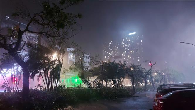
Streets in Dan Phuong district, Hanoi when the storm hit (Photo taken at 8:10 p.m.). Photo: Van Diep/VNA
According to the National Center for Hydro-Meteorological Forecasting, on the evening of September 7, due to the influence of storm No. 3's circulation, Bach Long Vi Island had strong winds of level 13, gusting to level 14; Co To Island had strong winds of level 13, gusting to level 16; Tien Yen (Quang Ninh) had strong winds of level 9, gusting to level 11; Dam Ha (Quang Ninh) had strong winds of level 10, gusting to level 13; Cua Ong (Quang Ninh) had strong winds of level 12, gusting to level 14; Phu Lien (Hai Phong) had strong winds of level 11, gusting to level 14; Cat Hai (Hai Phong) had strong winds of level 11, gusting to level 14; Dong Xuyen (Hai Phong) had strong winds of level 10, gusting to level 12; Ba Lat (Thai Binh) had strong winds of level 9, gusting to level 12; Van Ly (Nam Dinh) had strong winds of level 7, gusting to level 8; Hai Duong had strong winds of level 12, gusting to level 13; Luc Ngan (Bac Giang) strong wind level 9, gust level 11; Hung Yen strong wind level 8, gust level 11; Bac Giang strong wind level 7, gust level 9; Bac Ninh strong wind level 7, gust level 10;...
The Northeast region has had heavy to very heavy rain. The rainfall from 00:00 to 19:00 on September 7 was over 200mm in some places such as: Cat Ba (Hai Phong) 215mm, Dong Trieu (Quang Ninh) 224mm, Cam Pha (Quang Ninh) 213mm, Mau Son (Lang Son) 220mm, Phu Duc (Thai Binh) 409mm, Xuan Thuy (Nam Dinh) 221mm,...
At 7:00 p.m. on September 7, the center of storm No. 3 was located at approximately 20.9 degrees North latitude; 106.0 degrees East longitude, on land in the Northern Delta region. The strongest wind near the center of the storm was level 10-11 (89-117 km/h), gusting to level 14, moving in a West Northwest direction at a speed of 15-20 km/h.
At 7:00 a.m. on September 8, the center of storm No. 3 was at about 21.4 degrees North latitude - 104.3 degrees East longitude; on the mainland of the Northwest. The strongest wind near the center of the storm is level 6-7, gusting to level 9-10, moving in the West Northwest direction, speed 15-20 km/h. Affected areas include: the Gulf of Tonkin, the Northern region, risk level 3.
At 7:00 p.m. on September 8, the center of storm No. 3 was at approximately 21.9 degrees North latitude; 102 degrees East longitude, on the mainland of Upper Laos. The storm moved in a West-Northwest direction at a speed of 15-20 km/h, moving deep inland, weakening and gradually dissipating. The affected area was the North, with a risk level of 3.
At sea, the Gulf of Tonkin (including Bach Long Vi and Co To island districts) has strong winds of level 8-10, gusting to level 13; very rough seas.
In the Gulf of Tonkin (including Bach Long Vi and Co To island districts), waves are 3-5m high. In coastal waters from Quang Ninh to Ninh Binh, waves are 2-4m high.
Boat mooring areas, aquaculture areas, dykes and seawalls in the above-mentioned dangerous areas are all likely to be affected by strong winds, large waves and storm surges/ebb.
On land, coastal areas from Quang Ninh to Thanh Hoa have strong winds of level 7-8, near the storm center level 9-11, gusting to level 14; deep inland areas in the Northeast have strong winds of level 6-8, gusting to level 9-11 (strong winds will continue into the evening of September 7).
Along with that, the Northeast and Thanh Hoa from the evening of September 7 to the morning of September 8, there will be heavy to very heavy rain with common rainfall of 80-180mm, locally over 350mm. In the afternoon and night of September 8, there will be moderate rain, some places will have heavy rain and thunderstorms with common rainfall of 20-50mm, some places will have over 100mm. Particularly in mountainous areas, there will be heavy rain, some places will have very heavy rain with common rainfall of 60-120mm, locally over 250mm.
In the Northwest, from the evening of September 7 to the morning of September 9, there will be heavy to very heavy rain with common rainfall of 100-350mm, locally over 500mm.
Heavy rains can cause flooding in low-lying areas; flash floods on small rivers and streams; landslides on steep slopes. To ensure safety during storms, meteorological experts recommend that people monitor the storm's developments to proactively respond, stay indoors, in safe shelters, and limit going out if not necessary; turn off power sources when the storm makes landfall; absolutely do not stay on boats, watchtowers, rafts, or aquaculture areas when the storm makes landfall; do not return until the storm has passed.
In addition, people need to pay attention to the time when the storm center enters because there will be about 30 minutes to 1 hour of calm before the wind changes direction and the wind will be strong again; promptly and accurately inform the authorities of the location and dangerous situation in case of emergency; comply with the instructions of the authorities.
Source: https://baotintuc.vn/van-de-quan-tam/bao-so-3-giat-cap-14-trendat-lien-khu-vuc-dong-bang-bac-bo-20240907204533831.htm


![[Photo] Overcoming all difficulties, speeding up construction progress of Hoa Binh Hydropower Plant Expansion Project](https://vstatic.vietnam.vn/vietnam/resource/IMAGE/2025/4/12/bff04b551e98484c84d74c8faa3526e0)


![[Photo] Closing of the 11th Conference of the 13th Central Committee of the Communist Party of Vietnam](https://vstatic.vietnam.vn/vietnam/resource/IMAGE/2025/4/12/114b57fe6e9b4814a5ddfacf6dfe5b7f)


Comment (0)