According to the National Center for Hydro-Meteorological Forecasting, another tropical depression is likely to strengthen into a storm and move to the northeast of Luzon Island (Philippines). This causes storm No. 6 (Tra Mi) to move outward and weaken but create a very wide circulation.
Update on the location and path of storm No. 6 (storm Tra Mi)
At 1 p.m. on October 25, the center of the storm was located at approximately 17.6 degrees North latitude; 117.3 degrees East longitude, in the eastern sea of the North East Sea, approximately 560 km East Northeast of the Hoang Sa archipelago. The strongest wind near the center of the storm was level 10 (89-102 km/h), gusting to level 12. Moving in the West Northwest direction, speed 15-20 km/h.
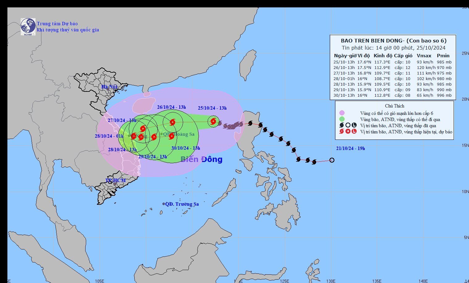
Latest update on the location and path of storm No. 6. Photo: NCHMF
Forecast of storm No. 6 in the next 24 to 72 hours:
| Forecast time | Direction, speed | Location | Intensity | Danger zone | Disaster Risk Level (Affected Area) |
| 13h/26/10 | West, about 20km/h | 17.5N-112.9E; on the Paracel Islands | Level 11-12, jerk level 15 | Latitude 15.0N-20.0N; East of longitude 110.5E | Level 3: North East Sea area (including Hoang Sa archipelago area) |
| 13h/27/10 | West Southwest, about 15km/h | 16.8N-109.7E; in the western area of Hoang Sa archipelago, about 180km northeast of Quang Tri-Quang Ngai | Level 10-11, jerk level 14 | Latitude 15.0N-20.0N; West of longitude 116.0E | Level 3: North East Sea area (including Hoang Sa archipelago area), Central Central Coast sea area |
| 13h/28/10 | Southwest, then East Southeast 5-10km/h | 15.9N-109.5E; in coastal waters of the Central Central provinces | Level 10, jerk level 12 | Latitude 14.5N-19.0N; West of longitude 112.0E | Level 3: West of the North East Sea area (including the area west of the Hoang Sa archipelago), the Central Central Coast sea area |
Warning: From the next 72 to 120 hours, the storm will move mainly to the East at 5-10km per hour, and its intensity will continue to weaken.
Sharing with the press, Mr. Nguyen Van Huong, Head of Weather Forecast Department, National Center for Hydro-Meteorological Forecasting, said that in the next 24 hours, storm Tra Mi is forecast to continue moving westward and is likely to strengthen to level 12. When passing the north of Truong Sa island, the storm's intensity tends to weaken due to the impact of cold air, remaining at level 10-11.
According to Mr. Huong, currently in the East of the Philippines there is a tropical depression and in the next 24-48 hours it is likely to strengthen into a storm and move to the Northeast of Luzon Island (Philippines), so there is interaction between the two storms. This causes storm No. 6 to move out and weaken. However, the satellite cloud image shows that the circulation of storm No. 6 is very wide and deviated to the West.
The North and Central East Sea are the main areas affected by strong winds. From the afternoon of October 26, the Central region has strong winds of level 6-7. When storm No. 6 approaches, it will increase to level 8-9. The sea area to the East of the North East Sea has strong winds of level 8-9, near the storm's eye it has levels 10-12 (89-133km/h), gusts of level 15, waves 5.0-7.0m high, near the storm's eye it has 7.0-9.0m; the sea is very rough. Ships operating in the above-mentioned dangerous areas (especially in the Hoang Sa island district) are likely to be affected by storms, whirlwinds, strong winds, and big waves.
The most likely scenario at present is that when approaching the sea area of the Central Central region (Quang Binh to Quang Ngai), the storm will continuously change direction from west to southwest, to southeast, then change direction from east, turn back to sea and gradually weaken. However, the probability of the storm making landfall in the Central provinces is still possible.
This storm is forecast to be very strong, with very complex developments. Its direction of movement and wind level may change due to the impact of many weather patterns at sea.
Mr. Nguyen Van Huong said that due to the influence of storm No. 6, from the evening of October 26, storm No. 6 may cause heavy rain in the Central region. Widespread rain from Ha Tinh to Phu Yen. Initial preliminary assessment shows that the rain will be concentrated from October 26 to 29, many places will have very heavy rain with rainfall up to 200-300mm.
Thus, the circulation before, during and after storm No. 6 may affect offshore and coastal waters of the Central region provinces (from Ha Tinh to Binh Dinh) from October 27 to 29.
To proactively respond to storms and floods that may occur in the mainland of the Central region due to the impact of storms, the Prime Minister requested Ministers and Chairmen of People's Committees of provinces and cities to proactively organize close monitoring, update forecast information and storm, rain and flood situations to promptly direct and deploy response work according to the "four on-site" motto according to assigned functions and tasks, not to be passive or surprised to ensure safety of life and minimize property damage for people.
On the impact of storm number 6 (storm Tra Mi)
In the North East Sea, the wind is strong at level 8-9, near the storm's eye it is level 10-12 (89-133km/h), gusting at level 15, waves are 5.0-7.0m high, near the storm's eye it is 7.0-9.0m; the sea is very rough. From early morning on October 27, the sea areas from Quang Binh to Quang Ngai (including Con Co and Ly Son island districts) will have winds gradually increasing to level 6-7, then increasing to level 8-9, near the storm's eye it is level 10-11, gusting at level 14, waves are 3.0-5.0m high, near the storm's eye it is 5.0-7.0m; the sea is very rough.
Ships operating in the above-mentioned dangerous areas (especially in the Hoang Sa island district) are likely to be affected by storms, whirlwinds, strong winds, and big waves.
Heavy rain warning: from the evening and night of October 26 to October 28, in the area from Quang Tri to Quang Ngai, there will be heavy to very heavy rain with total rainfall from 300-500mm, locally over 700mm. Warning of the risk of local heavy rain (>100mm/3 hours). The area of Ha Tinh-Quang Binh, Binh Dinh and the Northern Central Highlands will have heavy rain, locally very heavy rain with total rainfall from 100-200mm, locally over 300mm.
To ensure the safety of the dike system, the Department of Dike Management and Natural Disaster Prevention and Control requests the Department of Agriculture and Rural Development to report to the Provincial People's Committee to direct relevant agencies and units to urgently implement the following contents:
1. Strictly implement Official Dispatch No. 110/CD-TTg dated October 24, 2024 of the Prime Minister and Official Dispatches of the Ministry of Agriculture and Rural Development on response to storm No. 6.
2. Inspect, review and implement dike protection plans in practice, protect key areas of weak dikes; urgently reinforce dike locations where incidents have occurred but have not been handled or repaired, and unfinished dike and revetment projects (such as the Cau Hai Lagoon West Dike, Phu Loc District, Thua Thien Hue Province; the Ro Hamlet coastal erosion control embankment and the Da Dien estuary erosion control and silting embankment, Tuy Hoa City, Phu Yen Province).
3. Prepare manpower, materials, vehicles, machinery and equipment to promptly handle any incidents that may occur from the first hour, ensuring safety.
4. Closely monitor the developments of storms, post-storm floods and the situation of the dike system, promptly report dike incidents to the Department of Dike Management and Disaster Prevention and Control for coordination and direction.
 ") // // .removeAttr("style"); el.find(".first").show(); el.find("a.second").html(""); el.find("a.second").removeAttr("data-out"); $('.comment-account').html(`
 ") // // .removeAttr("style"); el.find(".first").show(); el.find("a.second").html(""); el.find("a.second").attr("data-out", "0"); $('.comment-account').html(` ") // .removeAttr("style"); //el.find("a.second").html(""); }); }; fnPopupBindAction(); //login Facebook var otherLogin = { init: function() { var me = this; //gapi.load('auth2', function () { // gapi.auth2.init({ // client_id: '678720187862-08lendtdt5h3nr4j2he534p15b13aieg.apps.googleusercontent.com', // scope: 'email profile', // fetch_basic_profile: true // }); //}); $("#cmt-account-social button[data-type]").on('click', function() { me[$(this).attr("data-type")](function(response) { $("#cmt-account-header .tabs .close, #cmt-account .tabs .close") .click(); }); }); try { fbClient.appId = '1304555827613749'; //'211029740744825'; fbClient.version = "v14.0"; fbClient.init(); setTimeout(FB.AppEvents.logPageView, 5000); } catch (e) { // ignore } }, loginFacebook: function(cb) { var me = this; function reloginFacebook(callback) { FB.api('/me', { fields: 'id, name, email' }, function(profile) { //console.debug(profile); if (typeof callback === "function") callback(profile); }); }; FB.login(function(response) { if (response.authResponse) { reloginFacebook(function(info) { console.log(info); info.social = "facebook"; info.accessToken = response.authResponse.accessToken; var user = { email: info.email, name: info.name, } let now = new Date(); lgSetCookie('my_dv',JSON.stringify(user), new Date(now.getTime() + (30 * 12 * 60000))); authLogin(user.name, true); }); } else { $("#cmt_alert").html( "You have denied access to your Facebook account"); } }, { scope: 'public_profile,email' }); }, loginGoogle: function(callback) { var me = this; function callSocialApi(data, cb) { data.social = "google"; var user = { email: data.email, name: data.name, } let now = new Date(); lgSetCookie('my_dv',JSON.stringify(user), new Date(now.getTime() + (30 * 12 * 60000))); authLogin(user.name, true); } // API call for Google login if (gapi.auth2.getAuthInstance().isSignedIn.get()) { //console.debug('[VCC] GAPI Process'); var profile = gapi.auth2.getAuthInstance().currentUser.get().getBasicProfile(); //var id_token = gapi.auth2.getAuthInstance().currentUser.get().getAuthResponse().id_token; var access_token = gapi.auth2.getAuthInstance().currentUser.get().getAuthResponse() .access_token; var params = { id: profile.getId(), name: profile.getName(), email: profile.getEmail(), accessToken: access_token } //console.log('params: ', params); callSocialApi(params, callback); } else { //console.debug('[VCC] GAPI Login'); gapi.auth2.getAuthInstance().signIn().then( function(success) { var profile = gapi.auth2.getAuthInstance().currentUser.get() .getBasicProfile(); //var id_token = gapi.auth2.getAuthInstance().currentUser.get().getAuthResponse().id_token; var access_token = gapi.auth2.getAuthInstance().currentUser.get() .getAuthResponse().access_token; var params = { id: profile.getId(), name: profile.getName(), email: profile.getEmail(), accessToken: access_token } //console.log('params: ', params); callSocialApi(params, callback); }, function(error) { $("#cmt_alert").html( "You have declined the grant permission for Dan Viet Newspaper to access Google account" ); } ); } } } otherLogin.init(); });
Source: https://danviet.vn/tin-bao-so-6-moi-nhat-anh-huong-hoan-luu-bao-so-6-noi-nao-se-hung-mua-rat-lon-20241025143832071.htm


![[Photo] Prime Minister Pham Minh Chinh chairs Government Conference with localities on economic growth](https://vstatic.vietnam.vn/vietnam/resource/IMAGE/2025/2/21/f34583484f2643a2a2b72168a0d64baa)