
LIMIT, AREA
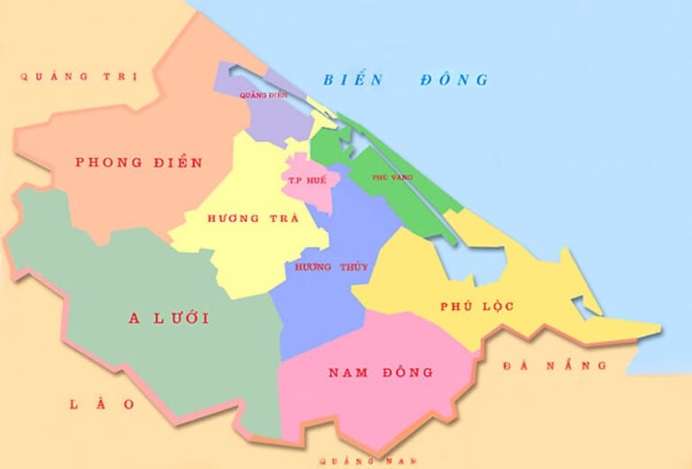
Thua Thien Hue shares land borders with Quang Tri province, Quang Nam province, Da Nang city, Lao People's Democratic Republic and borders the East Sea.
To the North, from East to West, Thua Thien Hue shares a 111.671 km border with Hai Lang, Dakrong and Huong Hoa districts, Quang Tri province. From the South, the province shares a 56.66 km border with Hien district, Quang Nam province, and a 55.82 km border with Hoa Vang district, Da Nang city. To the West, the provincial border (which is also the national border) extends from the northern point (the border between Thua Thien Hue province and Quang Tri province and the Lao People's Democratic Republic) to the southern point (the border between Thua Thien Hue province and Quang Nam province and the Lao People's Democratic Republic) with a length of 87.97 km. To the East, it borders the East Sea along a 120 km long coastline.
On the mainland, Thua Thien Hue stretches in the Northwest - Southeast direction, the longest part is 120 km (along the coast), the shortest part is 44 km (the western part); expanding horizontally in the Northeast - Southwest direction with the widest part along the cutting line from Quang Cong commune (Quang Dien), Tu Ha town (Huong Tra) to Son Thuy - Ba Le commune (A Luoi) 65km and the narrowest part is the southernmost land mass of only about 2-3km.
The continental shelf of the East Sea of Thua Thien Hue extends naturally from the mainland to the 12-nautical-mile baseline and is called the internal waters. The width of the internal waters of the continental shelf of Thua Thien Hue is calculated according to the straight line connecting point A11 (Con Co Island, Quang Tri) with coordinates 17 0 10'00'' North latitude and 107 0 00'26" East longitude to point A10 (Ly Son Island, Quang Ngai) with coordinates 15 0 23'01'' North latitude and 109 0 09'00" East longitude. The exclusive economic zone extends to 200 nautical miles from the baseline.
It is worth noting that on the continental shelf of the East Sea, about 600m northeast of the nearest Khem cape, there is Son Cha Island. Although the island's area is not large (about 160ha), it plays an important role in socio-economic development and national security protection for our country in general and Thua Thien Hue province in particular.
Thua Thien Hue is located on an important North-South traffic axis, the East-West corridor connecting Thailand - Laos - Vietnam along Highway 9. Thua Thien Hue is located in the middle of the country, between Hanoi and Ho Chi Minh City, the two major centers of the two most developed economic regions of our country, the intersection of natural - economic - social conditions of both the South and the North. Thua Thien Hue is one of the major cultural, tourism, educational and training centers, and healthcare centers of the country and is an important economic development pole of the key economic region of the Central region.
The province's coastline is 120 km long, with Thuan An port and Chan May bay with a depth of 18 - 20 m, which is suitable for building a deep-water port with large capacity. There is Phu Bai airport located on National Highway 1A and the trans-Vietnam railway running along the province, with an 81 km border with Laos.
The above geographical location has created favorable conditions for Thua Thien Hue to develop commodity production and expand socio-economic exchanges with provinces in the country and internationally.
According to Thua Thien Hue Gazetteer - Natural Section
(Social Sciences Publishing House - 2005)
![[Photo] Visiting Cu Chi Tunnels - a heroic underground feat](https://vstatic.vietnam.vn/vietnam/resource/IMAGE/2025/4/8/06cb489403514b878768dd7262daba0b)


![[Photo] National Assembly Chairman successfully concludes official visit to Uzbekistan](https://vstatic.vietnam.vn/vietnam/resource/IMAGE/2025/4/9/8a520935176a424b87ce28aedcab6ee9)


Comment (0)