
TPO - The Hydrometeorological Agency forecasts that the peak of high tide in Ho Chi Minh City is likely to occur on November 2-3 (ie October 2-3 of the lunar calendar). In particular, at Phu An station (Saigon River) and Nha Be station (Dong Dien canal), it may reach 1.55-1.60m (approximately or 0.05m lower than Alarm Level III).
TPO - The Hydrometeorological Agency forecasts that the peak of high tide in Ho Chi Minh City is likely to occur on November 2-3 (ie October 2-3 of the lunar calendar). In particular, at Phu An station (Saigon River) and Nha Be station (Dong Dien canal), it may reach 1.55-1.60m (approximately or 0.05m lower than Alarm Level III).
According to the Southern Hydrometeorological Station, water levels at most stations downstream of the Saigon - Dong Nai river system have dropped slowly in the past 24 hours.
As of 7:00 a.m. this morning, October 30, the highest water level measured at the stations was below Alert Level I, except for Thu Dau Mot station (Saigon River) at 1.53m (0.03m above Alert Level II).
Water levels at most stations in the downstream of the Saigon - Dong Nai River will rise slowly in the next 5 days.
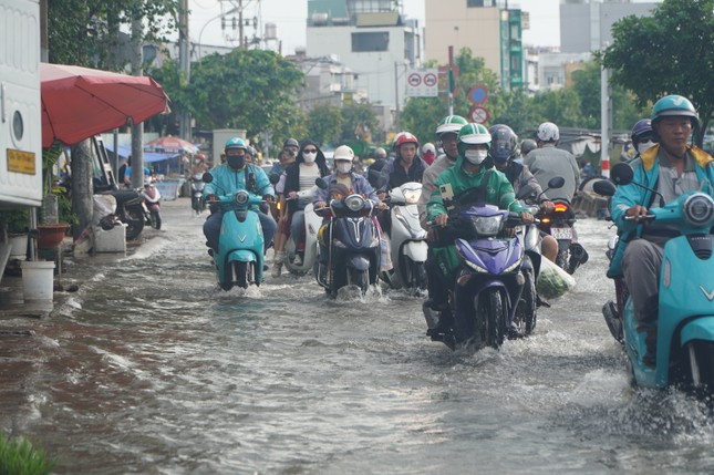 |
The Hydrometeorological Agency forecasts that the peak tide in Ho Chi Minh City is likely to occur on November 2-3 (ie October 2-3 of the lunar calendar). (Illustration photo) |
The peak tide of this period is likely to appear on November 2-3 (ie October 2-3 of the lunar calendar) and at the following levels:
At Phu An station (Sai Gon river) and Nha Be station (Dong Dien canal), the level can reach 1.55-1.60m (approximately or 0.05m lower than Alarm III). The peak tide time is 5-6am and 5-7pm.
At Thu Dau Mot station, it can reach 1.63-1.68m (0.03-0.08m above Alarm Level III); At Bien Hoa station, it can reach 1.80-1.85m (approximately or 0.05m above Alarm Level I). The level of natural disaster risk in the downstream area of Saigon - Dong Nai River is at level 2.
Thus, compared with the high tide peak in the middle of the last lunar month of September (October 19-21), the water level at Phu An and Nha Be stations during the high tide on November 2 and 3 is forecasted to decrease by 0.13-0.15m.


Source: https://tienphong.vn/tphcm-sap-don-dinh-trieu-cuong-post1686862.tpo

![[Photo] Queen of the Kingdom of Belgium and the wife of President Luong Cuong visit Uncle Ho's Stilt House](https://vstatic.vietnam.vn/vietnam/resource/IMAGE/2025/4/1/9752eee556e54ac481c172c1130520cd)
![[Photo] President Luong Cuong and the King of Belgium witness the Vietnam-Belgium document exchange ceremony](https://vstatic.vietnam.vn/vietnam/resource/IMAGE/2025/4/1/df43237b0d2d4f1997892fe485bd05a2)
![[Photo] President Luong Cuong meets with King Philippe of Belgium](https://vstatic.vietnam.vn/vietnam/resource/IMAGE/2025/4/1/1ce6351a31734a1a833f595a89648faf)
![[Photo] Official welcoming ceremony for the King and Queen of the Kingdom of Belgium](https://vstatic.vietnam.vn/vietnam/resource/IMAGE/2025/4/1/9e1e23e54fad482aa7680fa5d11a1480)


Comment (0)