
Previously, leaving Phu Quy outpost island, about 2 years ago (March 2022), I had a business trip to Da Nang City. Although the time was not much, through the arrangement of my former student (currently a student at Duy Tan University), we had the opportunity to visit some places in this "livable city".
I still remember that morning after admiring the scenery of Son Tra mountains and forests, I wanted to visit Dien Hai citadel - an important fortress in the early years of fighting against the French colonialists (1858-1860); but because I was not familiar with the road, I changed my plan and visited the Hoang Sa Exhibition House.
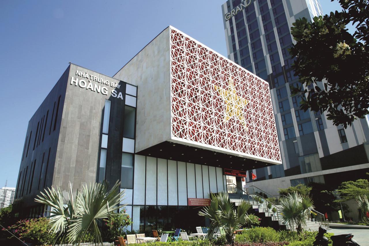
As soon as we entered the exhibition hall, the first impression we had was a building that was not tall but had an impressive architecture - the shape of a sovereign seal. Standing out was a square block, the facade was covered in the red color with a yellow star of the national flag on the path leading to the tourist area, making me extremely emotional because it was the first time I had "visited" the island district.
The explanatory document said that Hoang Sa Exhibition House was established on August 8, 2017, and officially opened to visitors from March 28, 2018. It is displaying more than 300 documents, artifacts, maps, and images; divided into 5 display themes. 1 - Geographical location and natural conditions of Hoang Sa archipelago. 2 - Hoang Sa in ancient Vietnamese documents before the Nguyen Dynasty. 3 - Hoang Sa in ancient Vietnamese documents during the Nguyen Dynasty (1802-1945). 4 - Evidence of Vietnam's sovereignty over Hoang Sa from 1945 to 1974. And theme 5 - Evidence of Vietnam's sovereignty over Hoang Sa from 1974 to present.
Through visiting the exhibits, reading the documents and listening to the exhibition staff's explanations, I have a better understanding of the Hoang Sa archipelago - one of Vietnam's important archipelagos in the East Sea, as well as the process of establishing sovereignty, exploitation and management through many regimes from the 16th century to the present. First of all, there is the system of ancient maps, compiled and drawn in the 17th-19th centuries.
One of the earliest maps mentioning Hoang Sa discovered in Vietnam is “Toan tap Thien Nam tu chi lo do thu” compiled by Do Ba in 1686. The displayed copy is a photocopy of the copy with the code MF.40 currently stored at the French School of the Far East (EFEO) in Paris. The second copy is “Thien ha ban do”, compiled during the Le Dynasty (18th century), copied during the Nguyen Dynasty (19th century).
The footnote (in Han Nom script) states that in the past, Hoang Sa was called Bai Cat Vang. “In the middle of the sea, there is a sandbar, called Bai Cat Vang, about 400 miles long, 20 miles wide, standing tall in the middle of the sea. From Dai Chiem estuary to Sa Vinh estuary, every time there is a southwest wind, merchant ships from the inland countries drift here, when there is a northeast wind, ships from the outer countries also drift here and all starve to death, all kinds of goods are left there. Every year, in the last month of winter (December), the Nguyen Dynasty sent 18 ships there to collect goods, mostly gold, silver, currency, guns and ammunition” (translated version of pages 77-78 of Thien Nam Tu Chi Lo Do Thu Luat Luat at the exhibition house).
In the exhibition room of theme 3 - evidence under the Nguyen Dynasty, there is "Dai Nam Nhat Thong Toan Do" drawn in 1838 under the reign of King Minh Mang. This is the first administrative map of the Nguyen Dynasty with a clear distinction between Hoang Sa and Van Ly Truong Sa in the East Sea. The second map - "An Nam Dai Quoc Hoa Do" drawn by Bishop Jean Louis Taberd and printed in the Latin - Annam dictionary published in 1838. On it is a drawing of the Paracel Islands located in the waters of Vietnam with coordinates close to reality, along with the caption "Paracel seu Cat Vang" (Paracel means Cat Vang).
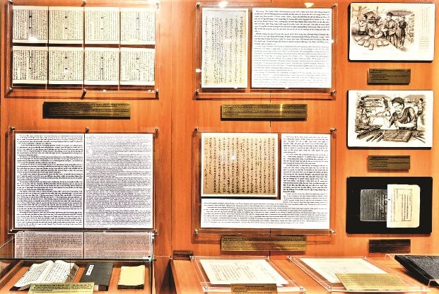
Not only displaying Vietnamese documents, the Hoang Sa Exhibition House also introduces a number of Chinese documents published by the West and China confirming that Chinese territory does not include the Hoang Sa and Truong Sa archipelagos. Some of these include: the Nhi Kinh Thap Bat Tinh Tong Do and the Quang Dong Quan Do printed in the book The Nhi Kinh Thap Bat Tinh Cuong Vu Toan Do compiled by Dong Diao Van Ta Ve Mon, published in China in 1850; the map of the Great Qing Empire in the book The Great Qing Empire Toan Do published by the Shanghai Commercial Press in 1908. Notably, the Hoang Trieu Truc Tinh Dia Du Toan Do published by the Qing Dynasty in 1904 shows that the southernmost border of China is limited to Hainan Island, without any mention of the so-called Xisha and Nansha, namely the Hoang Sa and Truong Sa archipelagos of Vietnam.
Second is the system of royal documents - administrative documents of the Nguyen Dynasty. These are memorials, edicts, decrees, etc. personally read or approved by the emperor. The royal documents on display, accompanied by translations, show that the Nguyen kings exercised sovereignty over Hoang Sa in a very specific manner, fully and honestly reflecting the process of establishing and exercising sovereignty of this dynasty through continuously sending people to Hoang Sa to survey, plant markers, and measure maps.
Third is the source of documents from the Republic of Vietnam period, such as: Telegram from the commander of Duncan Island (Quang Hoa) sent to the Quang Nam Provincial Security Group regarding the monitoring and investigation of two Chinese boats landing on a small island in the North of the Hoang Sa archipelago on February 25, 1961; Secret Telegram No. 08/NA/MM, dated March 4, 1961 from the Quang Nam Provincial Governor to the Minister of the Interior, concurrently telegraphing to the Minister of the Saigon Presidential Palace asking for instructions on how to handle the nine people on the Chinese boat landing on Hoang Sa island on March 1, 1961; or the Proclamation of the Supreme Court Council dated January 29, 1974 confirming the sovereignty of the nation of Vietnam over the Hoang Sa and Truong Sa archipelagos...
At the exhibition of evidence of Vietnam's sovereignty over Hoang Sa from 1945 - 1974, we heard the exhibition staff explain very clearly, saw pictures and documents about the event of the Chinese army using force to illegally invade Vietnam's Hoang Sa archipelago on January 19, 1974; about the heroic sacrifice of Vietnamese naval officers that moved everyone.
Since the event of January 19, 1974, the Vietnamese State has continued to fight to protect sovereignty over the Hoang Sa archipelago on political, diplomatic and legal fronts; at the same time, it has continued to implement administrative state management of the archipelago. On December 11, 1982, the Council of Ministers of the Socialist Republic of Vietnam (now the Government) issued Decision 194-HDBT on the establishment of Hoang Sa district in Quang Nam - Da Nang province. After separating from Quang Nam province and becoming a centrally-run city, Hoang Sa island district was placed under the management of the Da Nang government according to Decree No. 07/CP dated January 23, 1997 of Prime Minister Vo Van Kiet. Through the documents displayed during this period, it can be seen that since becoming a directly-run island district, the Da Nang city government has... Da Nang has had many propaganda activities, continuing to affirm sovereignty over Hoang Sa... and the establishment of Hoang Sa Exhibition House is a testament to the great efforts of the city government in administrative management and continuing to fight to protect and affirm sovereignty over Hoang Sa archipelago.
It can be said that Hoang Sa Exhibition House is a cultural and historical institution with a very special political significance. Through 5 exhibition halls, it has introduced and promoted extremely vivid information, documents and images, which have historical value in proving the process of exploration, establishment and protection of the sovereignty of the Vietnamese people on Hoang Sa archipelago. Therefore, since its inauguration, the Exhibition House has welcomed tens of thousands of domestic and foreign visitors to visit, study and research.
Leaving Da Nang, I returned to the small island of Phu Quy in Binh Thuan with the gifts of documents, the affection of the people of the port city, and the excitement and pride of the history of establishing and protecting the sovereignty of our nation's sea and islands. I thought to myself, one day Hoang Sa island district will return to reunite with the Fatherland in reality.
Source
![[Photo] Visiting Cu Chi Tunnels - a heroic underground feat](https://vstatic.vietnam.vn/vietnam/resource/IMAGE/2025/4/8/06cb489403514b878768dd7262daba0b)


Comment (0)