
The province's master plan along the Red River not only absorbs the achievements of developed countries but also ensures that it is consistent with the current status of the Red River, with the ability to expand and connect inter-regionally in the coming period.
From idea to reality

The Phu Thinh Bridge construction project, the 9th bridge across the Red River in the province, has just been officially put into operation. Not only a transportation project, the modern bridge with a total investment of more than 450 billion VND, designed with the imprints of the river and mountain shape of Lao Cai, has become an architectural highlight of Lao Cai provincial capital city, a connecting point, opening up development space on the left bank of the Red River. This is one of the key infrastructure projects to realize the urban planning idea along the Red River of Lao Cai provincial leaders through many periods.
Before 2000, along the Red River in Lao Cai province, there were mainly rural areas or small towns with low population scale; transportation and infrastructure in the riverside area were very limited, mainly small roads connecting to the center of Lao Cai city. During this period, Lao Cai did not have a clear planning strategy for the areas along the Red River because the economy was still heavily dependent on agriculture and there was not much investment in urban development.

In the period 2000 - 2010, with the economic development and integration policy of Vietnam, Lao Cai began to transform from a difficult mountainous province to an important economic center of the border gate. During this period, the planning of the Red River bank was shaped. Lao Cai city was planned to expand towards the Red River bank, river management projects, embankments on both banks with new residential areas, public works and commercial infrastructure were implemented. Large bridges such as Coc Leu bridge and Pho Moi bridge were built to connect the two banks of the Red River and promote trade between regions in the province.
The riverside area, especially near the Lao Cai International Border Gate, is planned as a border trade and service area. Lao Cai has begun to take measures to protect the flow of the Red River, prevent erosion and flooding. Parks and green areas along the river are included in the planning to improve the landscape and living environment.
The period 2011 - 2020 marked important steps in urban planning along the Red River when Lao Cai's socio-economic achievements were remarkable. Lao Cai City was recognized as a type II urban area in 2014, creating a strong driving force for the expansion and development of riverside urban space.

Key projects along the Red River are being promoted, including the modernly planned Kim Thanh commercial area, located near the Lao Cai International Border Gate and along the Red River, focusing on services, trade and logistics. In addition to the existing bridges, Lao Cai continues to invest in building new bridges and expanding riverside roads, connecting with neighboring areas. An Duong Vuong Street - the busiest road in Lao Cai city - was formed during this period when the province began implementing the Red River planning from Coc Leu Bridge to Pho Moi Bridge to create land funds for building service works and housing projects to generate revenue for the budget.
From 2021 to present, in the context of Lao Cai being oriented to become a major socio-economic center of the Northwest region, urban planning along the Red River continues to be promoted with specific goals. Lao Cai city continues to expand to the South and East along the two banks of the Red River. New urban areas are planned to be modern, smart and sustainable. The province focuses on building industrial parks, logistics services and riverside trade to take advantage of border trade.
Creating new growth drivers
Looking at the world, up to now, there have been many successful urban areas with planning on both sides of the river, developed such as the Tien Duong River (Hangzhou - China), the Han River (Seoul - Korea), the Thames River (London - England), the Seine River (Paris - France)... Even in the provinces and cities in the country, there are many valuable lessons, typically in Da Nang city with the viewpoint of identifying the Han River as an important highlight. Lessons learned at home and abroad have been drawn for Lao Cai to realize the urban planning of the Red River.
 has just been recognized as meeting the criteria of a type IV urban area.")
According to the Department of Construction, up to now, the Red River flowing through Lao Cai province has basically been covered by general planning such as: General planning of Lao Cai province's border gate economic zone; General planning of Lao Cai city; General planning of Pho Lu urban area; General planning of Bao Ha - Tan An urban area; Planning along the Red River connecting Lao Cai city urban area with Pho Lu urban area; General planning of construction along the Red River connecting Pho Lu urban area with Bao Ha - Tan An urban area.
The province is studying and finalizing the general planning scheme for construction along the Red River with 5 functional zones to orient the development of space along both banks of the Red River. Organizing the development of urban space, residential areas, and functional areas to attract investment, develop supporting industries, services, and agricultural and forestry production. With a new vision, the urban zoning plan will be oriented towards the Red River, prioritizing green belts combined with urban landscapes, creating a harmonious space for development on both sides of the river.
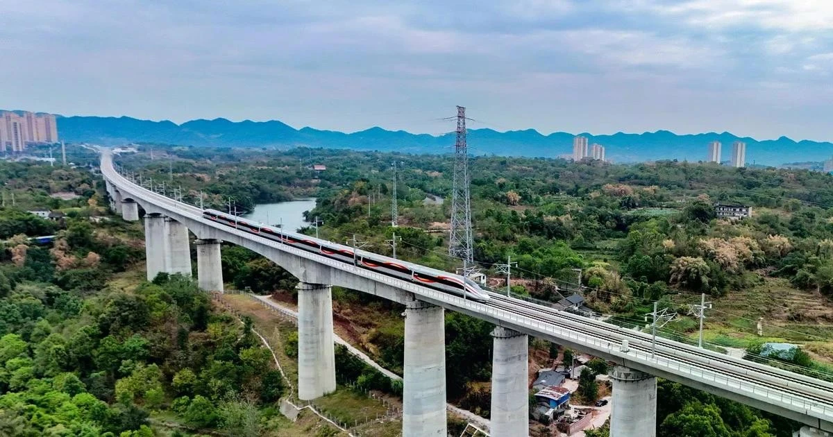
In parallel with the completion of the master plan, through each phase, vertical and horizontal connection infrastructure projects have also been implemented. If previously, the connection along the Red River only included National Highway 70, National Highway 4E and the Hanoi - Lao Cai railway, now there are also Noi Bai - Lao Cai expressway, Pho Moi - Bao Ha road, Kim Thanh - Ngoi Phat road... Bridges across the Red River have also been invested in and built to ensure connection on both sides of the river. After Lang Giang Giang bridge, the 9th and 10th bridges, Phu Thinh bridge and Ban Vuoc border bridge, are also being invested in and built.

This year, the 4-lane Noi Bai - Lao Cai Expressway Project; the Lao Cai - Hanoi - Hai Phong Standard Gauge Railway Project will be implemented. In addition, there are horizontal connecting traffic axes such as: Traffic connecting Lang Giang Bridge - National Highway 70; Noi Bai - Lao Cai Expressway connection project to Lai Chau; Noi Bai - Lao Cai Expressway connection to Sa Pa town... The strong investment in connecting infrastructure has created a lot of room for development, ensuring a harmonious balance between the two banks of the river and spreading from North to South with clear subdivisions. From there, effectively exploiting land funds to attract investment, creating revenue for the local budget, affirming the motto of planning associated with resource exploitation.

Urban planning along the Red River in Lao Cai is not only a short-term development strategy but also a long-term vision, aiming to turn Lao Cai into a modern, sustainable and environmentally friendly city. In the future, riverside urban areas will become ideal living spaces, cultural, economic and tourism highlights of the province, making an important contribution to the prosperity of the Northwest region as well as the Vietnam - China economic corridor.
Lesson 2: Building a city by the river
Source: https://baolaocai.vn/bai-1-hinh-thanh-khong-gian-truc-dong-luc-doc-song-hong-post399206.html


![[Photo] Closing of the 11th Conference of the 13th Central Committee of the Communist Party of Vietnam](https://vstatic.vietnam.vn/vietnam/resource/IMAGE/2025/4/12/114b57fe6e9b4814a5ddfacf6dfe5b7f)


![[Photo] Overcoming all difficulties, speeding up construction progress of Hoa Binh Hydropower Plant Expansion Project](https://vstatic.vietnam.vn/vietnam/resource/IMAGE/2025/4/12/bff04b551e98484c84d74c8faa3526e0)


Comment (0)