
According to the National Center for Hydro-Meteorological Forecasting, currently (October 1), cold air has affected some mountainous areas in the North of our country.
During the day and tonight, this cold air mass will continue to affect other places in the North, then the North Central region and some places in the Central Central region. The wind will change direction to Northeast level 3 inland, level 4-5 in coastal areas.

According to the meteorological agency, during this cold air mass, the weather in the North and North Central regions will turn cool; nights and early mornings will be cold, especially in the mountainous areas of the North.
The lowest temperature in the North and Thanh Hoa is generally from 19-22 degrees, in mountainous areas 17-19 degrees, in high mountainous areas below 16 degrees; in Nghe An - Ha Tinh the lowest temperature is from 20-23 degrees.
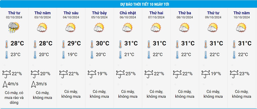
As for Hanoi's weather , tonight the weather will turn cool with the lowest temperature of 21-23 degrees; from the night of October 2-4 the lowest temperature will be 19-21 degrees.
In addition, the meteorological agency said that this morning, in the Northwest, Viet Bac, Thanh Hoa and Nghe An regions, there will still be rain, moderate rain and scattered thunderstorms, locally heavy rain with rainfall of 10-30mm, locally over 60mm.
This afternoon and evening, in the Northwest region, the Northern Delta, Thanh Hoa and Northern Nghe An, there will be scattered showers and thunderstorms, locally heavy rain with rainfall from 10-30mm, locally over 70mm.
From this afternoon to tomorrow (October 2), the area from Southern Nghe An to Thua Thien Hue will also have moderate rain, heavy rain and thunderstorms, locally very heavy rain with common rainfall from 30-70mm, locally over 150mm.
Tomorrow afternoon and night, in the area from Da Nang to Binh Dinh and the Central Highlands, there will be scattered showers and thunderstorms, locally heavy rain with rainfall from 10-30mm, some places over 100mm.
Thus, with the above weather patterns, after the rain caused by the cold air, people in the North will enjoy the autumn weather with sunshine, dry wind and chill at night and morning. The transitional season has begun. This type of weather will last continuously for the next 7-8 days.
The Central Central provinces have prolonged rain, not heavy but almost every day, especially in Thua Thien Hue area.
The South is still mainly affected by the southwest monsoon, so there is still a possibility of thunderstorms in the afternoon. Rain also tends to decrease in the coming days.
Further forecast, from the night of October 2-10, the National Center for Hydro-Meteorological Forecasting said that the North and Thanh Hoa will have no rain at night, sunny during the day. The weather will be cool, cold at night and early morning, especially in mountainous areas from the night of October 2-4, cold at night and early morning. From October 3, there will be scattered fog and light fog in the early morning.
In other regions, the weather during this period has little change. Specifically, in the North Central region, from the night of October 2-4, the weather will be cold. In the Central Central region, on the night of October 2, there will be scattered showers and thunderstorms, with some heavy rain; from October 5-6, there will be scattered showers and thunderstorms in some places. In the South Central region, there will be scattered showers and thunderstorms in some places. In the Central Highlands and the South, there will be scattered showers and thunderstorms in the afternoon and evening.
The Meteorological Agency warns that heavy rain and localized heavy rain may cause flooding in low-lying areas; flash floods on small rivers and streams, landslides on steep slopes. During thunderstorms, there is a possibility of tornadoes, lightning, hail and strong gusts of wind.
Regarding storm Krathon, which has become storm number 5 in the East Sea, at 10:00 this morning, the eye of the storm is located in the northeastern sea of the North East Sea. The strongest wind near the eye of the storm is level 16 (184-201 km/h), gusting over level 17; moving in the West Northwest direction, speed about 5 km/h. According to current forecasts, the storm is unlikely to affect coastal areas and mainland of our country.

Weather forecast for the next 10 days: Heavy rain with cold air in the North, then sunny
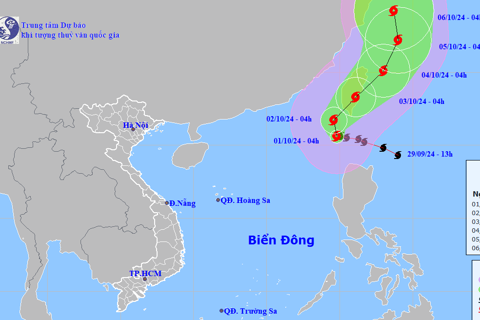
Storm Krathon enters the East Sea as storm number 5, gusting above level 17
Source: https://vietnamnet.vn/khong-khi-lanh-bat-dau-tran-ve-mien-bac-dieu-mat-ca-tuan-2327616.html

![[Photo] National Assembly Chairman Tran Thanh Man attends the Policy Forum on Science, Technology, Innovation and Digital Transformation](https://vstatic.vietnam.vn/vietnam/resource/IMAGE/2025/4/13/c0aec4d2b3ee45adb4c2a769796be1fd)

![[Photo] Prime Minister Pham Minh Chinh chairs the Government's special meeting on law-making in April](https://vstatic.vietnam.vn/vietnam/resource/IMAGE/2025/4/13/8b2071d47adc4c22ac3a9534d12ddc17)
![[Photo] National Assembly Chairman Tran Thanh Man attends the ceremony to celebrate the 1015th anniversary of King Ly Thai To's coronation](https://vstatic.vietnam.vn/vietnam/resource/IMAGE/2025/4/13/6d642c7b8ab34ccc8c769a9ebc02346b)


Comment (0)