
(NLDO) - The presence of the De Lanessan ship of the Institute of Oceanography on all islands in the Hoang Sa and Truong Sa archipelagos is proof of Vietnam's sovereignty.
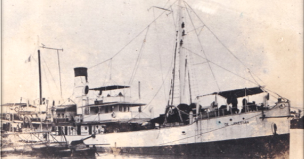
Official information from the Institute of Oceanography said that the marine research ship named De Lanessan of the Indochina Institute of Oceanography (now the Institute of Oceanography - Vietnam Academy of Science and Technology) operated from 1925-1942.
In 1922, Governor-General of Indochina FM Baudoin signed a decree to establish the Indochina Fisheries Oceanography Department (the predecessor of today's Institute of Oceanography) in Nha Trang and appointed Dr. Armand Krempf as Director of the department.
To serve scientific research, the French Government has equipped the institute with a marine research vessel named De Lanessan. The vessel has a capacity of 750 tons, built to serve fisheries and oceanographic research within the framework of a project by Dr. A. Krempf funded by the French Government.
The ship was launched in Bordeaux on June 21, 1924. After a 63-day journey, the ship docked at Hai Phong port on November 7, 1924.

De Lanessan 1926 ship at Saigon port
The ship is fully equipped with modern equipment, the best fishing nets according to European standards, using engines, can cast nets in deep waters. On deck there are tools for collecting oceanographic samples, the ship has a laboratory for research on marine flora and fauna and plankton.
In addition, the ship also has a large compartment with areas for conducting post-harvest product research with advanced machinery at that time. It is a machine that processes fresh fish products very quickly and easily into fishmeal, ensuring adequate nutrition and storage conditions. A steam centrifuge can quickly extract the fat of fish and other marine animals, then process and preserve. A machine that can process raw materials for fish sauce production. A large refrigerator for deep freezing fresh fish products; equipment for processing and sterilizing post-harvest fish products.

Trawl equipment and laboratory of the De Lanessan
The research team of the De Lanessan ship consisted of Captain Dauguet, Chief Engineer Pépin, and Logistics Officer Aubry. Mr. Krempf was responsible for managing the ship's operations, but when Mr. Krempf went to France, Mr. Tollard was given management authority.
The activities of collecting specimens for the Museum were led by Mr. Gruvel and assisted by Mr. Chabanaud (fish expert), the eel expert was Mr. Schmidt from Denmark, and Mr. Lemoine - professor of geology at the Muséum d'Histoire Naturelle de Paris was in charge of building a fishery map based on geographical and ecological factors.

Photo of the crew of the De Lanessan taken at the Institute of Oceanography
At the end of March 1925, the ship began its first research survey. On April 7, 1925, the ship began surveying the Gulf of Tonkin. From April 1925 to April 1930, the ship conducted 52 surveys, collecting samples from 577 stations in deep sea areas on the continental shelf of Vietnam, the Gulf of Tonkin, the Gulf of Thailand, the Paracel Islands, the Spratly Islands, the Mekong River, the Cambodian Tonle Sap Lake, and the waters of the Indonesian island of Borneo (trip 21 from September 2 to 14, 1926, this was the ship's farthest trip).
In June 1926, the De Lanessan continued its research in the Hoang Sa archipelago. For more than a month, the ship took scientists to the islands: Tri Ton, Da Loi, Bach Quy, Phu Lam, Cay island, Linh Con, Bong Bay reef, Huu Nhat island, and Luoi Liem island to conduct surveys on depth, temperature, currents, geology, and some flora and fauna on and around the island. The scientists' diaries showed that there were many seabirds on these islands and scientists found phosphate mines created by bird droppings with reserves of about 8 million m3 .

Dr. Truong Si Hai Trinh - Deputy Head of Information and Communication Department, Institute of Oceanography, introduces the voyages of the De Lanessan ship.
In July 1927, the ship De Lanessan surveyed the islands: An Bang, Da Tay, Da Chu Thap, Ba Binh, Loai Ta, Da Subi, Thi Tu, Song Tu island cluster in Truong Sa archipelago. Scientists surveyed the bottom, collected animal and geological samples, measured the depth... and obtained many important data. Then, in 1930, the Indochina Institute of Oceanography (the new name of the Indochina Fisheries Oceanography Department) cooperated with the French Navy to survey and research the islands in Truong Sa archipelago (An Bang, Da Dong, Ba Binh, Song Tu, Thi Tu...), including surveying the coral bottom, collecting biological samples, coral sand samples and discovering a 30cm thick layer of phosphate and a dense seabird fauna here.
After 1930, the De Lanessan ship continued to make many survey trips to the Hoang Sa and Truong Sa archipelagos.
All information about the De Lanessan's survey trips from 1925-1929 is published in the Report of the Indochina Institute of Oceanography "ION Note 17: Campagnes du "De Lanessan"

Then, from April 1933, the De Lanessan continued to survey the Paracel Islands and the Gulf of Thailand with French naval ships. The De Lanessan, the Alerte and the Astrolabe surveyed the Spratly Islands, west of Palawan, and conducted thermal measurements in the waters of the Spratly Islands.
In 1934-1935, the ship studied the interaction between the climate in the Indochina peninsula and the hydrological regime in the East Sea of Vietnam, adding the content of salinity research in the study of the hydrological regime of the East Sea. From there, a set of maps of the hydrological regime in the East Sea and the Gulf of Thailand was established.
In 1937, during the survey of Hoang Sa by the ship De Lanessan, the location for building a lighthouse for the international maritime route at Hoang Sa island was determined. The ship proposed scientific bases for planning Hoang Sa island (Documentation sur les iles Paracels et Spratly, 1953).
From these results, in March 1938, the Hydrological Observation Station was established in the Paracel Islands (in coordination with the Meteorological Department), which collected data on temperature and salinity from August 1938 to September 1939 (ION Rapport 1938-1947, Annexes, Plance VI: Table of temperature and salinity measurements of surface water in the Paracel Islands from August 1938 to September 1939).

The Journey of the De Lanessan
Based on the results of measurements and research on hydrometeorological and dynamic factors in the East Sea and continental shelf, scientists of the Institute have published works.
That author Krempf A. (1926, 1927, 1928, 1929) published the results of measurements and research on surface and deep hydrometeorological factors from the Hoang Sa and Truong Sa archipelagos to the Gulf of Tonkin, the southern continental shelf and the Gulf of Thailand in the years 1929-1933.
Authors Chevey P. & Carton P. (1934) published research on flow and results of hydrometeorological measurements in the East Sea. The authors discovered underground water with a temperature of 20-21oC flowing from North to South.

Dangerous waters in the Spratlys recorded and mapped by scientists on board the De Lanessan
Authors Chevey P. (1933-1934), Krempf A. et Chevey P. (1936) described the surface hot current system and the deep cold current system that are permanent along the coast of Vietnam in the North-South direction even during the Southwest monsoon season, creating an antagonism between these two water masses. The cold water mass below 25oC has moved further south, while the hot water mass above 250C has moved further north... These results can be considered the first data related to the phenomenon of upwelling in the coastal area of Vietnam. Later, it was further studied by American scientists (NAGA Program) and Vietnam.
Author Serène R. (1957) published a report on Vietnam's oceanographic physics research at the UNESCO Conference held in Tokyo in 1955.
Regarding climate research, there are official publications on Indochina climate and tropical cyclones in the East Sea by the authors: Bruzon E., Carton P. (1930); Bruzon E., Carton P., Romer A. (1950).
Documentary clip about the De Lanessan ship is archived at the Nha Trang Institute of Oceanography
Assoc. Prof. Dr. DAO VIET HA - Director of the Institute of Oceanography: With the resources collected from the survey trips, the Indochina Institute of Oceanography published and exhibited 4 maps of the East Sea at the International Colonial Exhibition in Paris in 1931. Including the map of the stations of the De Lanessan ship's survey trips in the East Sea. In addition, in the annual reports, the Institute published a map of the depth of the Truong Sa archipelago (in 1930), a map of the formation of coral reefs in the islands: Ba Binh, Loai Ta, Thi Tu, Subi Reef and warnings of dangerous areas for fishing (in 1933).
Source: https://nld.com.vn/hoang-sa-truong-sa-qua-dau-tich-nghien-cuu-bien-cua-tau-de-lanessan-196250127152653831.htm


Comment (0)