
Hanoi approves plans and locations of many roads in Dong Anh and Thanh Oai districts
Vice Chairman of Hanoi People's Committee Duong Duc Tuan has signed and issued Decisions approving plans and locations of many roads in Dong Anh and Thanh Oai districts.
Approval of plan and location of TD8 route in Dong Anh district
Vice Chairman of Hanoi People's Committee Duong Duc Tuan signed and issued Decision No. 4847/QD-UBND on approving the plan and location of route TD8 from Hanoi - Lao Cai railway to Dong Anh Industrial Park, scale 1/500.
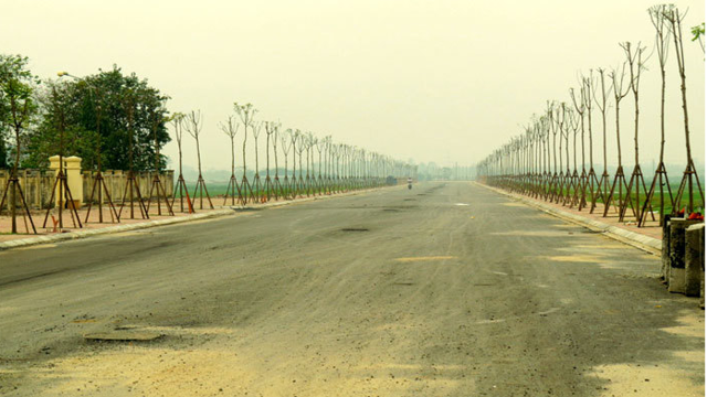
 |
| Illustration. |
According to the Decision, the plan and location of the TD8 route from the Hanoi - Lao Cai railway to Dong Anh Industrial Park, scale 1/500, prepared by the Hanoi Institute of Construction Planning, and appraised by the Hanoi Department of Planning and Architecture. The starting point is at the intersection with the existing Hanoi - Lao Cai national railway, the end point is at the intersection with the planned road south of Dong Anh Industrial Park, with a length of about 2.88 km. Route direction: in accordance with the General Construction Plan of the Capital, the Transport Plan of the Capital and the approved Urban Sub-Zone Plans N6, N7, GN, GN (B).
The cross-section scale of road B = 50 m includes the following components: roadway 2 x 11.25 m (6 lanes), median strip 11.5 m, sidewalks on both sides 2 x 8 m. At the intersection of the national railway line Eastern beltway and beltway 3 North Red River, build an overpass on the 28 m wide strip of land in the middle of the road, roadway along both sides of the bridge 2 x 7 m, sidewalks on both sides 2 x 4 m. The specific cross-section components will be determined precisely according to the road construction investment project approved by the competent authority.
The intersections at the intersection of the route with the Eastern National Railway and the Northern Red River Ring Road 3 will be arranged with direct overpasses. The intersections along the route are level intersections preliminarily determined based on the road network according to the approved planning. Specifically, they will be further studied and determined accurately during the detailed planning process for both sides of the route or the investment project for the cross-road route approved by the competent authority.
Hanoi City People's Committee assigned the Department of Planning and Architecture to check and confirm the plan drawings and route locations according to the approval decision of Hanoi City People's Committee.
Dong Anh District People's Committee shall preside over and coordinate with relevant agencies to organize the public announcement of the approved route plan and location for relevant organizations and individuals to know and implement; deploy the work of setting up road boundary markers at the same time as carrying out land acquisition and site clearance during the implementation of the investment project; strictly manage land and construction order on both sides of the road according to the approved planning, plan and location of the road.
Approval of the plan and location of the Ta Hong dike route in Dong Anh district
Vice Chairman of Hanoi People's Committee Duong Duc Tuan signed and issued Decision No. 4849/QD-UBND on approving the plan and location of Ta Hong dike road in Dong Anh district, scale 1/500.
According to the Decision, the plan and location of the Ta Hong dike route in Dong Anh district (from K48+165 to K64+126), scale 1/500, was prepared by the Hanoi Institute of Construction Planning and approved by the Hanoi Department of Planning and Architecture. The starting point intersects with the Duong River dike in Xuan Canh commune, the end point is at the border between Dai Mach commune, Dong Anh district and Trang Viet commune, Me Linh district. The route length is about 16 km.
The route is determined based on the existing dike route, in accordance with the General Construction Plan of the Capital, the Transport Plan of the Capital, the approved urban subdivision plans N4, N8, GN, GN(A), and the Red River. The route includes sections with grades from regional main roads, inter-regional roads to urban main roads.
The road on the dike has a width from B = 11.0 m to B = 18.5 m, typical cross-section: B = 11 m including components: 7.5 m roadway (2 lanes), sidewalk (2.5 + 1) m; B = 18.5 m including components: 15 m roadway (4 lanes), sidewalk (2.5 + 1) m.
The dike toe inside the urban area has a width from B = 11 m to B = 13.5 m, the typical cross-section includes the following components: roadway 7 - 7.5 m (2 lanes), sidewalk on the dike side is 1 m wide, sidewalk on the urban residential side is 3 - 5 m wide. At the sections of the route passing through the North Hanoi Smart City area and the section coinciding with the main urban route TC13, the dike toe is built according to the scale of an urban road with B = 28 m (4 main lanes, 2 service lanes) and B = 42.5 m (6 main lanes, 2 service lanes).
The dike foot road outside the river has a width of B = 11 m, the typical cross-section includes the following components: 7 m roadbed (2 lanes), 1 m wide sidewalk on the dike side, 3 m wide sidewalk on the outside.
Typical cross-sections of the route are shown on the approved route plan and location drawings attached to this Decision. The components of the road cross-section will be determined precisely according to the road construction investment project approved by the competent authority.
Hanoi City People's Committee assigned the Department of Planning and Architecture to check and confirm the plan drawings and route locations according to the approval decision of Hanoi City People's Committee.
Dong Anh District People's Committee shall preside over and coordinate with relevant agencies to organize the public announcement of the approved route plan and location for relevant organizations and individuals to know and implement; deploy the work of setting up road boundary markers at the same time as carrying out land acquisition and site clearance during the implementation of the investment project; strictly manage land and construction order on both sides of the road according to the approved planning, plan and location of the road.
Approval of plan and location of Ta Thanh Oai axis road
Vice Chairman of Hanoi People's Committee Duong Duc Tuan has just signed and issued Decision No. 4897/QD-UBND on approving the plan and location of Ta Thanh Oai axis road, scale 1/500.
According to the Decision, the plan and location of the Ta Thanh Oai axis road, scale 1/500, prepared by the Hanoi Institute of Construction Planning, was appraised by the Department of Planning and Architecture. The road is located in Ta Thanh Oai commune, Thanh Tri district. The route is consistent with the Gs urban zoning plan, scale 1/5000, approved by the City People's Committee in Decision No. 3976/QD-UBND dated August 13, 2015. The starting point of the route intersects with the road connecting Ta Thanh Oai road with the road connecting road 70 running along the Hoa Binh river (point 1); The end point of the route intersects with the Ta Thanh Oai - Dai Ang - Lien Ninh road (point 11); the route length is about 2.7 km.
The route has a typical cross-sectional scale of B = 25.0 m, the cross-sectional components include: 15.0 m wide roadway (4 lanes); 2 x 5.0 m wide sidewalks on both sides. The structure of the cross-sectional components of the route will be specifically determined during the process of establishing the road construction investment project approved by the competent authority.
The intersections on the planned routes are determined to be level crossings. The red line boundaries at the intersections and cross-roads will be specifically determined during the process of establishing investment projects for works in the area approved by competent authorities.
The Hanoi City People's Committee assigned the Department of Planning and Architecture to inspect and confirm the project documents and location of the Ta Thanh Oai axis road, scale 1/500, in accordance with the content of this Decision.
Thanh Tri District People's Committee shall preside over and coordinate with the Department of Planning and Architecture and relevant units to organize the announcement and handover of the project documents and location of the Ta Thanh Oai axis road approved by the City People's Committee to the Ta Thanh Oai Commune People's Committee to manage the construction planning along both sides of the road; deploy the installation of road boundary markers according to the planning at the same time as the implementation of land acquisition and site clearance (during the implementation of the road investment project) to avoid waste and overlap in the work of installing boundary markers.
Thanh Tri District People's Committee and Ta Thanh Oai Commune People's Committee are responsible for organizing and managing boundary markers and construction order of works along both sides of the road according to the red line and approved boundary markers. Inspecting and handling cases of planning violations according to authority and regulations of law.
Recognition of the project to celebrate the 70th anniversary of the Liberation of the Capital of Dong Anh district
Chairman of Hanoi People's Committee Tran Sy Thanh signed Decision No. 4787/QD-UBND on recognizing the project to celebrate the 70th anniversary of the Liberation of the Capital and rewarding achievements in implementing the project.
Accordingly, 4 works celebrating the 70th anniversary of the Liberation of the Capital (October 10, 1954 - October 10, 2024) were recognized, including: An Duong Vuong Secondary School, Dong Anh District (Project name: Viet Hung 2 Secondary School); Nhue Village Kindergarten Center, Kim Chung Commune, Dong Anh District; Xuan Canh Kindergarten, Dong Anh District; Xuan Canh Secondary School, Dong Anh District.


![[Photo] Prime Minister Pham Minh Chinh chairs Government Conference with localities on economic growth](https://vstatic.vietnam.vn/vietnam/resource/IMAGE/2025/2/21/f34583484f2643a2a2b72168a0d64baa)


Comment (0)