
Weather forecast for the next 10 days (February 20 - March 1), cold air will continuously strengthen, the North and North Central regions will have showers, the weather will turn cold, very cold. The Central Central region to the South will have rain, locally heavy rain.
Experts from the National Center for Hydro-Meteorological Forecasting have just made a prediction on weather developments in the next 10 days (February 20 - March 1, 2025).
Accordingly, the continental cold high pressure (cold air) will weaken in intensity, gradually move to the East and change; from around February 22-23, it is likely to continuously strengthen, then stabilize in intensity and gradually weaken.
Above, the westerly wind currents will remain in the Northern region, from around February 25-26 forming a westerly wind trough. The subtropical high pressure tends to gradually move westward, causing disturbances in the easterly wind above the Central region until around February 25.
Due to the influence of the above patterns, the weather in regions across the country has many fluctuations, especially prolonged cold rain in the North and Central regions and unseasonal thunderstorms in the Central Highlands and the South.
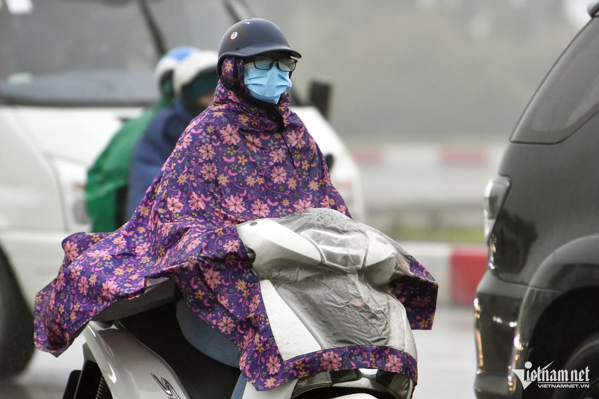
Specifically, in the North from February 20-21, there will be light rain, drizzle and fog, especially in the Northwest region, there will be rain in some places, early morning there will be scattered fog and light fog, sunny in the afternoon; from February 22-24, there will be scattered rain and light rain; from February 25-26, there will be scattered showers and thunderstorms; then the rain will decrease. It will be cold, with some mountainous areas having severe cold; from around the night of February 23-26, the mountainous and midland areas will have severe cold, with some places having severe cold.
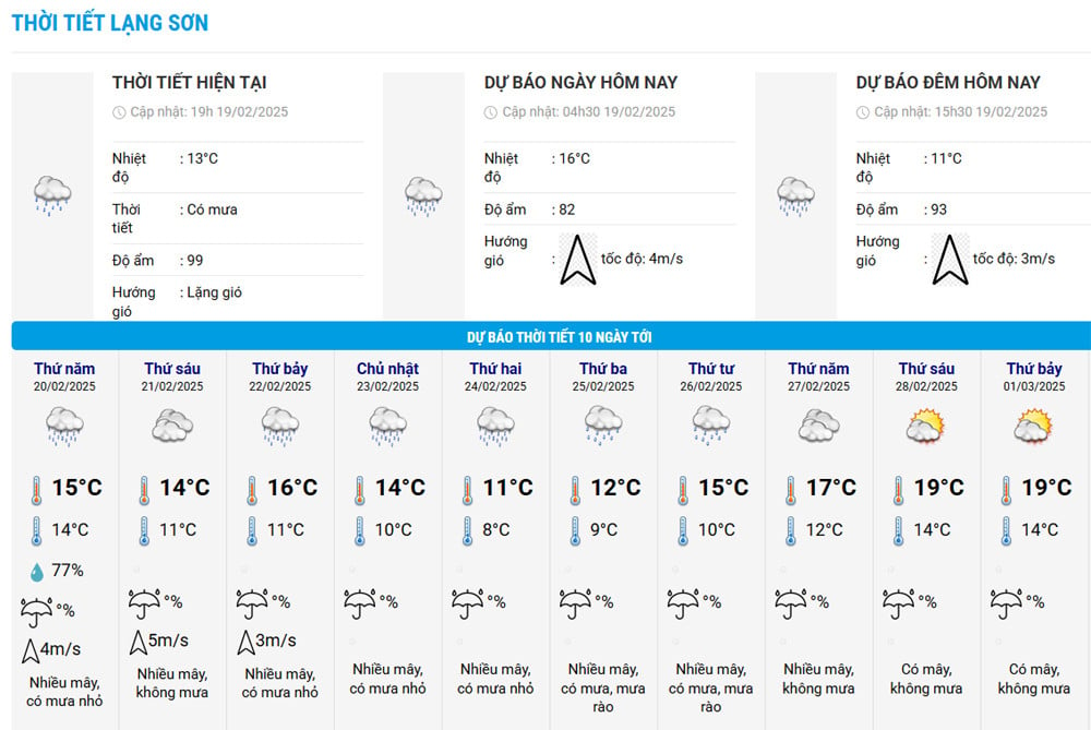
According to the temperature table of Lang Son province, the temperature dropped sharply from February 23 and continued to drop sharply on February 24-25 with the lowest temperature of 8-9 degrees and the highest of only 11-12 degrees.
North Central region on February 20, light rain in some places, early morning fog and light fog scattered; from February 21-24, rain, scattered light rain; from February 25-26, scattered showers and thunderstorms; later the rain decreases. Cold at night and morning; from about February 23-24, cold.
In the coming days, the Central and South Central regions will experience continuous rain; in which, from February 20-21, there will be scattered rain and showers; from about February 22-25, there will be moderate rain, locally heavy rain and thunderstorms; then the rain will decrease.
Meanwhile, the Central Highlands and the South will have showers and thunderstorms in some places. In the South Central Highlands and the South, unseasonal rain will appear from around February 22-23.
In Hanoi, from February 20-21, there will continue to be light rain, drizzle and fog; from February 22-24, there will be scattered rain and light rain; from February 25-26, there will be scattered showers and thunderstorms; then the rain will decrease. Cold weather.
In addition, meteorological experts also stated that in March, the cold air activity was approximately at the average of many years with the continental cold high pressure center tending to shift to the East, causing many days of light rain, drizzle and fog in the North. From April 2025, the cold air activity gradually decreased.
Also in March, heat waves are likely to appear late in the Central Highlands and the South with fewer days than in 2024. In the North and Central regions in March and April, heat waves may occur mainly in the Northwest, the North and the Central regions; the intensity of heat waves is likely to be less severe than in the same period last year.
Specifically about the weather in Hanoi capital in the first 3 days (February 20-22, 2025) :
| Day | Day (7am-7pm) | Night (7pm-7am) |
| 20/2 | Cloudy with light rain, drizzle and fog. Light wind. Cold. | Cloudy with light rain, drizzle and fog. Light wind. Cold. |
| 21/2 | Cloudy with light rain, drizzle and fog. Light wind. Cold. | Cloudy with light rain, drizzle and fog. Light wind. Cold. |
| 22/2 | Cloudy, with rain, light rain. East to northeast wind level 2-3. Cold. | Cloudy, with rain, light rain. East to northeast wind level 2-3. Cold. |

Continuous drizzle in the North, possibility of strong cold air at the weekend

Cold air shifts to the East, the North has many days of fog and drizzle
Source: https://vietnamnet.vn/du-bao-thoi-tiet-10-ngay-toi-don-khong-khi-lanh-manh-mien-bac-ret-dam-ret-hai-2373036.html
![[Photo] A brief moment of rest for the rescue force of the Vietnam People's Army](https://vstatic.vietnam.vn/vietnam/resource/IMAGE/2025/4/3/a2c91fa05dc04293a4b64cfd27ed4dbe)
![[Photo] Capital's youth enthusiastically practice firefighting and water rescue skills](https://vstatic.vietnam.vn/vietnam/resource/IMAGE/2025/4/3/3f8481675271488abc7b9422a9357ada)
![[Photo] Prime Minister Pham Minh Chinh chairs meeting after US announces reciprocal tariffs](https://vstatic.vietnam.vn/vietnam/resource/IMAGE/2025/4/3/ee90a2786c0a45d7868de039cef4a712)
![[Photo] General Secretary To Lam receives Japanese Ambassador to Vietnam Ito Naoki](https://vstatic.vietnam.vn/vietnam/resource/IMAGE/2025/4/3/3a5d233bc09d4928ac9bfed97674be98)
![[Photo] Ho Chi Minh City speeds up sidewalk repair work before April 30 holiday](https://vstatic.vietnam.vn/vietnam/resource/IMAGE/2025/4/3/17f78833a36f4ba5a9bae215703da710)
![[Photo] Prime Minister Pham Minh Chinh chairs the first meeting of the Steering Committee on Regional and International Financial Centers](https://vstatic.vietnam.vn/vietnam/resource/IMAGE/2025/4/3/47dc687989d4479d95a1dce4466edd32)


Comment (0)