
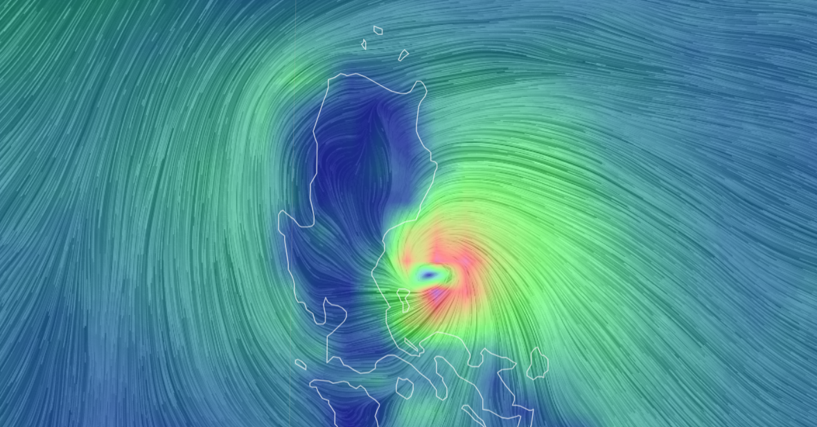
Entering the Gulf of Tonkin this morning, the fifth storm in the East Sea is forecast to peak at nearly 88 km/h (level 9) tomorrow, then weaken into a tropical depression.
The National Center for Hydro-Meteorological Forecasting said that at 7:00 a.m., the center of storm Sanba (international name of the fifth storm) was in the southeast of the Gulf of Tonkin, with the strongest wind speed of 74 km/h, level 8. The storm continued to move northwest at a speed of 10 km/h and could strengthen further, by 7:00 a.m. tomorrow in the northern Gulf of Tonkin, the strongest wind speed was level 8-9.
On October 21, due to interaction with cold air from the North, the storm turned south, weakened into a tropical depression and a low pressure area in the Gulf of Tonkin, with the strongest wind speed below level 6.
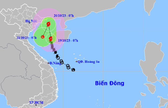
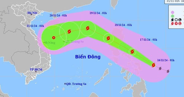
Forecast of the path and affected area of storm Sanba at 7am on October 19. Photo: NCHMF
Japanese and Hong Kong stations both predict that the storm will reach its peak speed of 85-88 km/h tomorrow morning in the middle of the Gulf of Tonkin, then turn south and quickly weaken. The forecast path is a bit different, while Vietnamese and Hong Kong stations predict that the storm will approach Hainan Island (China), the US Navy, Japan, and TSR of the University of London predict that the storm will keep its distance from the island.
Due to the storm, the Gulf of Tonkin (including Co To and Bach Long Vi islands) and the sea area of Quang Tri will have winds gradually increasing from level 6 to 9, gusting to level 11, waves 2-4 m high, then increasing to 3-5 m. From the night of October 19, the coastal areas of Quang Ninh and Thai Binh will have winds gradually increasing to level 6, gusting to level 7-8.
On land, from tonight to tomorrow night, the southern delta, northeastern part of the North and North Central regions will have 15-30 mm of rain, some places over 60 mm. This rainfall is much lower than previously forecast, because the storm is far from land. Rain in the Central region will decrease rapidly.
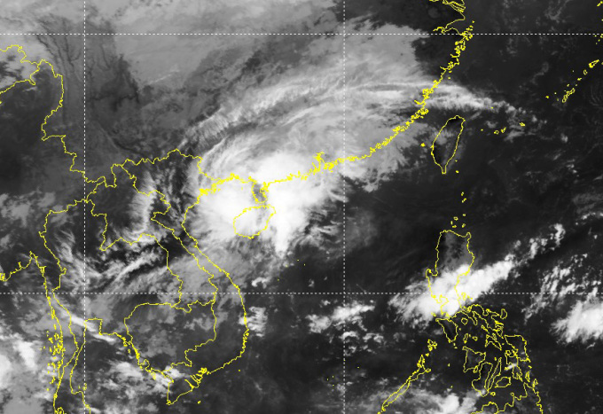
Satellite images show that the eye of the storm has moved away from the Vietnamese mainland and is approaching Hainan Island (China). Above, cold air is pouring down. Photo: NCHMF
Sanba is the fifth storm to hit the South China Sea this year. The previous two storms, Koinu and Sao La, entered the South China Sea and headed north, without affecting Vietnam. Another storm or tropical depression is forecast to appear in October.
The National Steering Committee for Natural Disaster Prevention yesterday afternoon requested coastal provinces from Quang Ninh to Binh Dinh to closely monitor the storm's developments, count boats and ships; coordinate with the Border Guard Command and the Department of Fisheries to guide boats and ships to anchor, take shelter, protect cages, watchtowers, and aquaculture areas; and proactively prohibit sea travel depending on the storm's developments.
On the night of the 16th and early morning of the 17th, two squid fishing boats near the Truong Sa archipelago were sunk by waves, killing two people and leaving 13 people missing.
Source link
![[Photo] Prime Minister Pham Minh Chinh receives CEO of Standard Chartered Group](https://vstatic.vietnam.vn/vietnam/resource/IMAGE/2025/4/2/125507ba412d4ebfb091fa7ddb936b3b)
![[Photo] Comrade Khamtay Siphandone - a leader who contributed to fostering Vietnam-Laos relations](https://vstatic.vietnam.vn/vietnam/resource/IMAGE/2025/4/3/3d83ed2d26e2426fabd41862661dfff2)
![[Photo] General Secretary To Lam receives Russian Ambassador to Vietnam](https://vstatic.vietnam.vn/vietnam/resource/IMAGE/2025/4/2/b486192404d54058b15165174ea36c4e)
![[Photo] Prime Minister Pham Minh Chinh receives Deputy Prime Minister of the Republic of Belarus Anatoly Sivak](https://vstatic.vietnam.vn/vietnam/resource/IMAGE/2025/4/2/79cdb685820a45868602e2fa576977a0)


Comment (0)