
Overview of the road that Hanoi is about to invest more than 21,000 billion VND to expand and build an elevated road
Thursday, May 9, 2024 12:50 PM (GMT+7)
To solve the traffic congestion on Ring Road 2, Hanoi will widen Lang Road from 21 m to 53.5 m, and build an elevated road from Nga Tu So to Cau Giay with a total investment of more than 21,000 billion VND.
Video: Panorama of Lang road before more than 21,000 billion VND was invested to expand and build an elevated road.

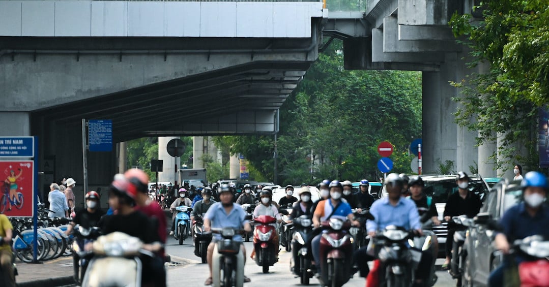
Lang Road (red line) is about 3.8 km long, stretching from Cau Giay intersection to Nga Tu So, running on the east bank of To Lich River. The route has a very high traffic density, often congested at intersections.

The Department of Transport has just reported to the City People's Committee on the implementation of the report proposing investment policies and pre-feasibility studies for a number of transport projects, including the Ring Road 2 section from Nga Tu So to Cau Giay (Lang Road). Accordingly, the investment project to renovate and expand the elevated and low-lying Ring Road 2 from Nga Tu So to Cau Giay is expected to have a total investment of over 21,000 billion VND, of which the lower section is less than 17,000 billion VND and the elevated section is nearly 3,900 billion VND.

Due to the large total investment, the Department of Transport proposed to split into two projects and prioritize the renovation and expansion of the low-lying Ring Road 2, about 3.8 km long, starting at the Nga Tu So intersection and ending at the Cau Giay intersection. The estimated cost is more than 17,000 billion VND, including site clearance of 16,700 billion VND and construction of 541 billion VND. With the investment project to build the elevated Ring Road 2, the starting point connects with the built elevated Ring Road 2 at the Nga Tu So intersection and the ending point is at the Cau Giay intersection. The route is 3.8 km long, 19 m wide, with a speed of 80 km/h, and is the main urban axis. The total estimated investment is nearly 3,900 billion VND, with an implementation period of 2026-2030.

Previously in 2019, to reduce traffic congestion, the Hanoi Department of Transport decided to cut the right sidewalk, close to the riverbank, to widen the road surface by an average of 3.5 m, and build a new 1.5 m wide sidewalk.

According to the Department of Transport, Lang Street is only 10.5 m wide each way, with a maximum traffic capacity of 3,000 vehicles/hour, but now it has reached 8,000 vehicles/hour, so it is often congested during rush hour.

Currently, Lang Street also has a lane reserved for pedestrians and cyclists on the side next to To Lich River.

This is also a route with 2 urban overpasses through the intersections of Lang - Nguyen Chi Thanh and Lang - Lang Ha.

Besides, Lang road also has 2 urban railway lines running through it: Cat Linh - Ha Dong and Nhon - Hanoi Railway Station.

Landscape of To Lich River next to Lang Road. Currently, Yen Xa wastewater treatment project is nearing completion, expected to improve the polluted water flow on To Lich River, the left bank of Nhue River and Lu River in Hanoi.

The project implementation is part of the plan to close the inner-city belts, reduce traffic pressure at the Nga Tu So intersection, and promote the effectiveness of the completed elevated beltway 2 section Vinh Tuy - Nga Tu So.
Pham Hung
Source: https://danviet.vn/toan-canh-con-duong-sap-duoc-ha-noi-dau-tu-hon-21000-ty-dong-de-mo-rong-va-xay-duong-tren-cao-20240509114251089.htm


![[Photo] Prime Minister Pham Minh Chinh holds talks with Prime Minister Mikhail Vladimirovich Mishustin](https://vstatic.vietnam.vn/vietnam/resource/IMAGE/2025/1/19/54ce88000228495a90768cc0b03c9cc0)


Comment (0)