
The center of storm Tra Mi is on the Philippines mainland, moving into the East Sea at a speed of 15-20km/h. Currently, in the northeastern sea of the North East Sea, there are strong northeast winds of level 6-7, sometimes level 8.
According to the National Center for Hydro-Meteorological Forecasting, at 1:00 a.m. on October 24, storm Tra Mi was located at approximately 17.2 degrees North latitude; 122.4 degrees East longitude, on the mainland east of Luzon Island (Philippines).
The strongest wind near the storm center is level 9-10 (75-102km/h), gusting to level 12. The storm moves in a West Northwest direction, at a speed of 15-20km/h.
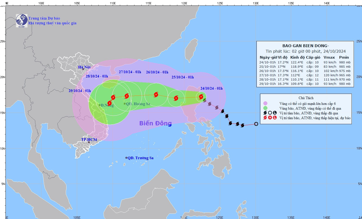
Storm forecast (next 24 to 72 hours):
| Forecast time | Direction, speed | Location | Intensity | Danger zone | Disaster Risk Level (Affected Area) |
|---|---|---|---|---|---|
| 1h/25/10 | West, about 15km/h, entering the East Sea | 17.0N-118.9E; on the eastern sea of the North East Sea area | Level 9, jerk level 11 | Latitude 14.0N-19.5N; East of longitude 116.5E | Level 3: East of the North East Sea area |
| 1h/26/10 | West Northwest, 10-15km/h | 17.5N-116.1E; 510km east of Hoang Sa archipelago | Level 10, jerk level 12 | Latitude 14.5N-20.5N; East of longitude 114.0E | Level 3: North East Sea area |
| 1h/27/10 | West, 15-20km/h | 17.3N-112.0E; in the sea north of Hoang Sa archipelago | Level 11-12, jerk level 15 | Latitude 14.5N-20.5N; East of longitude 109.5E | Level 3: North East Sea area (including Hoang Sa archipelago area) |
From the next 72 to 120 hours, the storm will move mainly in a westerly direction, traveling 10-15km per hour, then it will likely change direction to the southwest and move more slowly.
Thunderstorm warning in the East Sea
Currently, in the northeastern sea area of the North East Sea, there are strong northeast winds of level 6-7, sometimes level 8.
In the eastern sea area of the North East Sea, the Central and Southern East Sea areas (including the waters of the Truong Sa archipelago), the sea area from Binh Thuan to Ca Mau and the Gulf of Thailand, there will be showers and thunderstorms.
| Forecast time | Sea area of influence | Strong wind | Wave height | ||
|---|---|---|---|---|---|
| Day and night 10/24 | Wind level (Bophorus level) | Direction | Height (meters) | Direction | |
| Eastern Sea of the North East Sea area | Level 6-7, near the eye of the storm level 8-9, gusting to level 11. From noon on October 24, the wind will increase to level 8, near the eye of the storm level 9-10, gusting to level 12. Very rough seas | Multi-directional | 3.0-5.0, area near storm center 5.0-7.0 | Multi-directional | |
| The western sea area of the North East Sea (including the sea area of the Paracel Islands) | Level 6, sometimes level 7, gusting to level 8-9. Rough seas. | North to Northwest | 3.0-5.0 | Northeast | |
| The Middle East Sea Area | Level 6, especially in the eastern sea area, strong wind level 7, gusting to level 8-9. Rough sea. | North to Northwest | 3.0-5.0 | Multi-directional | |
| Sea area from Quang Tri to Binh Thuan | Level 6, gusts level 7-8. Rough sea. | North to Northwest | 2.0-3.5 | Northeast | |
| Eastern Sea of the South China Sea region | Level 5, sometimes level 6, gusting to level 7-8. Rough sea. | Southwest | 2.0-3.0 | Southwest | |
In addition, on the day and night of October 24, there will be storms in the eastern sea of the North East Sea, the Central and Southern East Sea (including the waters of the Truong Sa archipelago), the waters from Binh Thuan to Ca Mau, Ca Mau to Kien Giang and the Gulf of Thailand will have scattered showers and thunderstorms. During the thunderstorms, there is a possibility of tornadoes and strong gusts of wind of level 7-8.
Meteorological agency forecasts day and night October 25:
In the North East Sea (including the waters of Hoang Sa archipelago), strong winds of level 7-8, near the storm's eye level 9-10, gusting to level 12; waves 3-5m high, near the storm's eye 5-7m; very rough seas.
The northern sea area of the Central East Sea has strong winds of level 6, sometimes level 7, gusting to level 8-9; rough seas; waves from 3.0-5.0m high.
The sea area from Quang Tri to Khanh Hoa has strong northwest wind level 6, gusting to level 7-8; rough sea; waves from 2-4.5m high.
All vessels operating in the above areas are at high risk of being affected by cyclones, strong winds and large waves.

![[Photo] Third meeting of the Organizing Subcommittee serving the 14th National Party Congress](https://vstatic.vietnam.vn/vietnam/resource/IMAGE/2025/4/2/3f342a185e714df58aad8c0fc08e4af2)
![[Photo] Relatives of victims of the earthquake in Myanmar were moved and grateful to the rescue team of the Vietnamese Ministry of National Defense.](https://vstatic.vietnam.vn/vietnam/resource/IMAGE/2025/4/2/aa6a37e9b59543dfb0ddc7f44162a7a7)

![[Photo] Close-up of Vietnam's sniffer dog team searching for earthquake victims in Myanmar](https://vstatic.vietnam.vn/vietnam/resource/IMAGE/2025/4/1/d4949a0510ba40af93a15359b5450df2)


Comment (0)