
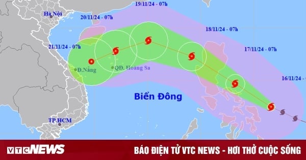
According to the National Center for Hydro-Meteorological Forecasting, tomorrow, November 15, storm USAGI (currently active in the sea area north of Luzon Island - Philippines) is forecast to enter the East Sea with a level 13 intensity, gusting to level 16, becoming storm number 9.
Latest storm news update, storm USAGI
According to the National Center for Hydro-Meteorological Forecasting, at 7:00 p.m. on November 14, the center of storm USAGI was located at approximately 18.5 degrees North latitude; 121.6 degrees East longitude, in the sea north of Luzon Island. The strongest wind near the center of the storm was level 13 (134-149 km/h), gusting to level 16.
Storm USAGI is moving northwest at about 15km/h.
2. Storm forecast ( next 24 to 72 hours):
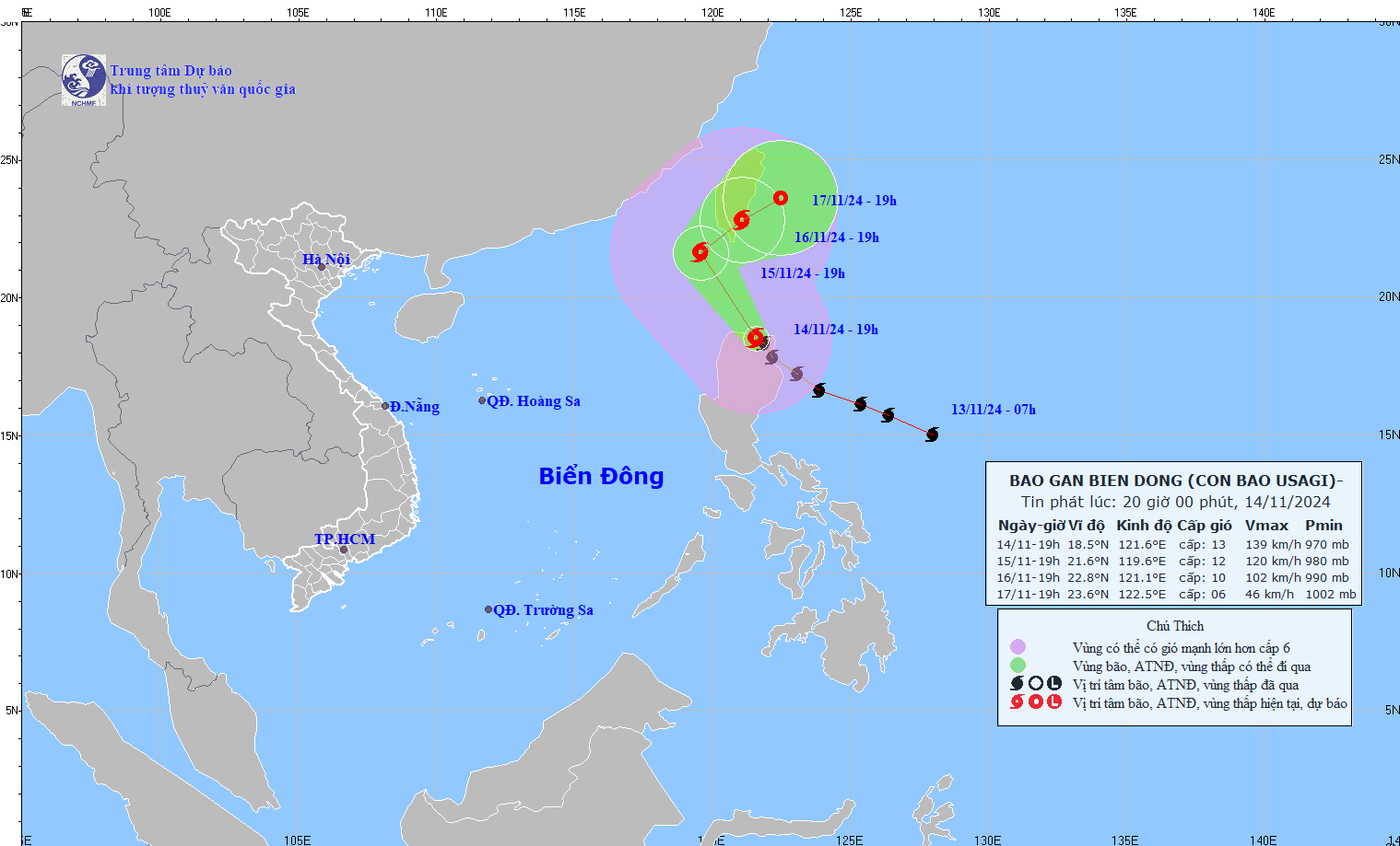
The movement of storm USAGI. Photo: nchmf.
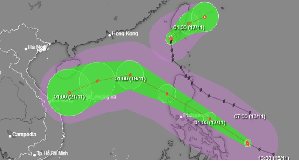
| Forecast time | Direction, speed | Location | Intensity | Danger zone | Disaster Risk Level (Affected Area) |
| 19:00/15/11 | Northwest, about 15km/h, going into the Northeast of the East Sea | 21.6N-119.6E; in the northeastern sea of the East Sea | Level 12, jerk level 15 | Latitude 17.5N-23.0N; East of longitude 118.0E | Level 3: Northeast of the North East Sea area |
| 19h/16/11 | Northeast, about 10km/h | 22.8N-121.1E; on the mainland south of Taiwan (China) | Level 10, jerk level 12 | Latitude 20.9N-26.0N; East of longitude 118.0E | Level 3: Northeast of the North East Sea area |
| 19:00/17/11 | Northeast, about 10km/h | 23.6N-122.5E; in the sea east of Taiwan | Level 6, level 8 jerk |
Forecast of the impact of storm USAGI
Due to the impact of storm USAGI, the eastern sea area of the North East Sea has winds gradually increasing to level 8-10, near the storm's eye level 11-13, gusting to level 16, waves 4.0-6.0m high, near the eye 6.0-8.0m; rough seas.
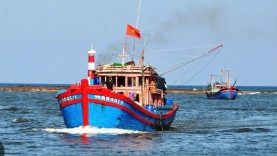
Ships operating in the above mentioned dangerous areas are likely to be affected by storms, whirlwinds, strong winds and large waves.
To proactively respond to the storm's developments, today, November 14, the Minister of Agriculture and Rural Development issued an official dispatch requesting ministries, branches, and Chairmen of People's Committees of coastal provinces and cities from Quang Ninh to Binh Dinh to closely monitor the storm's developments; manage means of transport going out to sea; organize the counting of ships and boats; notify owners of means of transport and captains of ships and boats operating at sea of the location, direction of movement and developments of the storm so that they can proactively avoid, escape or not move into dangerous areas.
Dangerous areas in the next 24 hours: From latitude 17.5-23.0 degrees North latitude, east of longitude 118.0 degrees East longitude; in the next 48 hours: From latitude 20.9-26.0 degrees North latitude, east of longitude 118.0 degrees East longitude (dangerous areas are adjusted according to forecast bulletins).
Ready forces and means for rescue when required.
Vietnam Television, Voice of Vietnam, Vietnam News Agency, the coastal information station system and mass media agencies from central to local levels have increased measures to inform authorities and people about the storm's developments so that they can proactively prevent and respond promptly and effectively.
Source: https://danviet.vn/khan-ngay-mai-15-11-bien-dong-lai-don-bao-usagi-bao-so-9-manh-gan-cap-sieu-bao-2024111421271106.htm


![[Photo] Looking back at the impressive moments of the Vietnamese rescue team in Myanmar](https://vstatic.vietnam.vn/vietnam/resource/IMAGE/2025/4/11/5623ca902a934e19b604c718265249d0)

![[Photo] "Beauties" participate in the parade rehearsal at Bien Hoa airport](https://vstatic.vietnam.vn/vietnam/resource/IMAGE/2025/4/11/155502af3384431e918de0e2e585d13a)


![[Photo] Summary of parade practice in preparation for the April 30th celebration](https://vstatic.vietnam.vn/vietnam/resource/IMAGE/2025/4/11/78cfee0f2cc045b387ff1a4362b5950f)


Comment (0)