
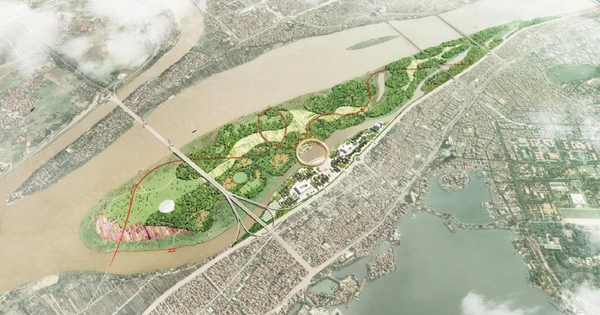
Hanoi's Red River alluvial plain has been proposed to become a multi-purpose cultural and ecological park, but its implementation is stuck in dike planning and flood prevention.
At the workshop on the project to build Bai Giua Cultural Park on November 24, Architect Nguyen Ba Nguyen, Deputy Director of the Hanoi Department of Planning and Architecture, said that according to the general planning and urban zoning plan of the Red River, the area of the middle sandbank and the alluvial area along the river is oriented to build a green landscape park, a cultural park, an urban square and works symbolizing the capital.
The Red River sandbank (also known as the middle sandbank) and the riverside were deposited by alluvium over many years, and are a large green space in the middle of the capital with an area of about 300 hectares. In recent years, the area of the middle sandbank has changed little with the rise and fall of flood waters because the water level of the Red River rarely rises. This area is under the management of the four districts of Tay Ho, Hoan Kiem, Long Bien, and Ba Dinh.
Hanoi needs to be given special policies.
According to Mr. Nguyen, first of all, the city will study and develop a project, detailed planning to turn the central area into a multifunctional cultural park, planning traffic routes connecting the inner city and the northern city in the future (according to the general planning of the capital under construction) and utility service works, serving the organization of major cultural and artistic events.
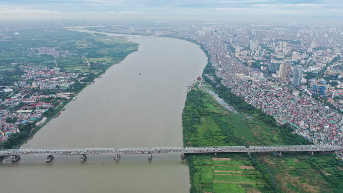
The sandbank area in the middle of the Red River. Photo: Ngoc Thanh
However, according to the flood prevention and dyke planning of the Red River and Thai Binh River systems, this is an area "used for economic and social development activities but no construction or housing is allowed".
Therefore, the Deputy Director of the Department of Planning and Architecture said that Hanoi needs to be given special policies to remove difficulties and obstacles in the detailed planning of the park area in the middle of the Red River.
District leaders also pointed out many shortcomings in the management of population and land in the middle of the sandbank area. Mr. Pham Tuan Long, Chairman of Hoan Kiem District, said that many people migrated from other provinces and are living in floating houses, affecting the environmental sanitation of the Red River landscape. Land violations are increasing, many households arbitrarily build temporary tents, bamboo frame houses, thatched roofs, or solidly build level 4 houses.
Meanwhile, Hoan Kiem residents live along the Red River with high density and lack of public space. According to Mr. Long, despite many problems, the sandbank is "an opportunity to promote the advantages of green space, water landscape, and meet the entertainment needs of the people".
"We agree not to develop urban areas in this area, but to define the middle sandbank area to serve community activities, exploit historical, cultural and heritage values along the river associated with the natural beauty of the Red River," said Mr. Long.
Mr. Nguyen Manh Ha, Chairman of Long Bien District, also said that Long Bien District currently has 180 hectares of mid-land, mostly agricultural land, growing fruit trees, ornamental flowers, and vegetables. The problem in land management is that many areas cannot be signed by the Ward People's Committee, causing violations of dikes and land use for the wrong purpose, illegal dumping of waste...
"The first policy mechanism that needs to be resolved is to assign Hanoi authorities to decide on the use and exploitation of land funds. Specifically, the Capital Law and the revised Land Law assign the city to decide on the exploitation of agricultural land funds along river banks," said the Chairman of Long Bien District.
Multi-park model
Discussing the detailed planning of the Red River sandbank area, Dr. Architect Ta Nam Chien, Chairman of Ba Dinh District, proposed the planning of the Red River Park including a new investment area covering the entire sandbank and riverside area; a renovated and embellished area including residential areas concentrated outside the dike in the wards of Phuc Tan, Chuong Duong (Hoan Kiem District), Phuc Xa (Ba Dinh District), Tu Lien, Quang An, Nhat Tan (Tay Ho District) and Ngoc Thuy (Long Bien District).
At the same time, the city creates squares in the central beach area, creating spatial highlights and landscape values that need to be connected such as Long Bien bridge, Dong Xuan market, Hang Dau water tower...
Dr. Architect Nguyen Van Tuyen, University of Construction, assessed the Red River sandbank as "an ecological gem in the heart of Hanoi, which has long become the largest and most unique bird garden in the capital". This place also has the overlapping urban heritage of Long Bien Bridge and the heritage system on both sides of the river. Therefore, Mr. Tuyen proposed the Red River sandbank according to many thematic park models.
Specifically, the eco-tourism park model focuses on promoting the landscape and endemic ecological environment, developing a system of semi-flooded forests, ecological nurseries, research gardens, sandbanks, water surfaces and restoring native flora and fauna systems.
A model of a historical and cultural park, promoting cultural and religious exchange activities. The park takes the urban heritage of Long Bien Bridge as the center, the landscape of the Red River as the background, forming cultural space routes connecting the heritage on both banks and the entire green corridor of the Red River.
Model of a science park with scientific and technological research and innovation activities. Expected functions such as a science and technology center, science incubator, and innovation garden.
Meanwhile, Dr. Architect Phan Dang Son, Chairman of the Vietnam Association of Architects, suggested that the middle of the beach become a traditional agricultural ecological park, combining high technology, that is, an agricultural garden representing the regions of Vietnam, with biodiversity of food and fruit trees. Camping, experiences, dining, and picnics will be organized here.
The alluvial plains on both sides of the river can organize functional areas of green park space, functional areas for growing short-term trees and ornamental flowers, combined with creating flexible spaces for regular artistic interactions, organizing sports activities, and community activities.
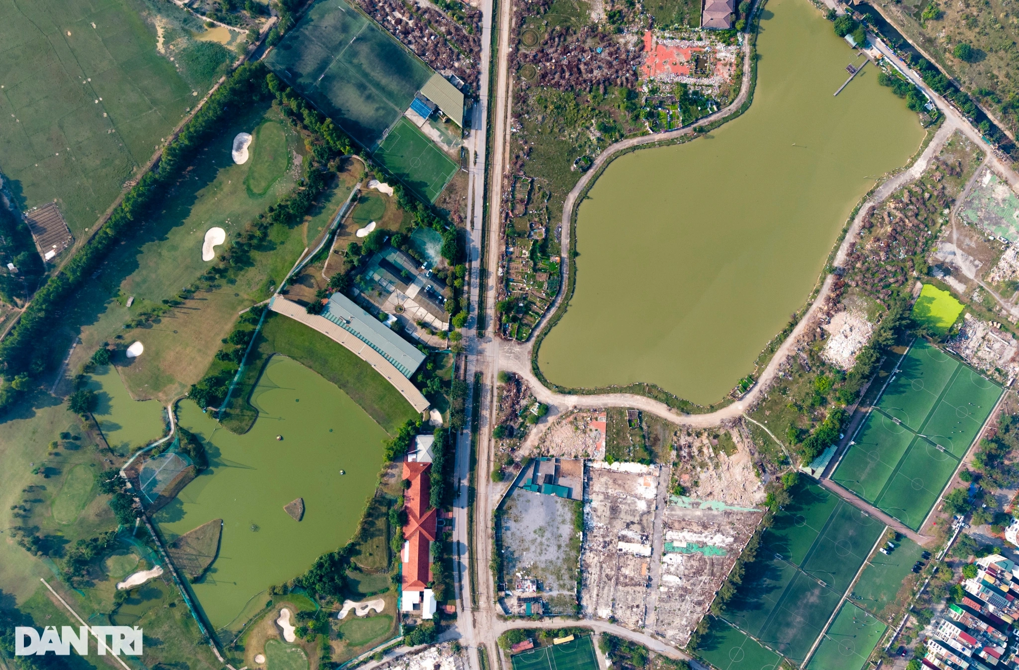
People mainly grow agricultural crops on the sandbank. Photo: Ngoc Thanh
According to the Red River urban zoning plan, the river flows through the inner city, stretching from Thang Long Bridge to Thanh Tri Bridge, with a population of over 181,000 and a total area of about 686 hectares. This place is oriented as a multifunctional area including cultural public works, commercial services and landscape spaces, and a historical spatial axis connecting West Lake - Co Loa.
To implement the planning, the City People's Committee assigned four districts of Hoan Kiem, Long Bien, Ba Dinh, and Tay Ho to study the project "Developing the floating area in the middle and along the Red River into a multi-purpose cultural park", funded from the district budget.
Source link


![[Photo] Closing of the 11th Conference of the 13th Central Committee of the Communist Party of Vietnam](https://vstatic.vietnam.vn/vietnam/resource/IMAGE/2025/4/12/114b57fe6e9b4814a5ddfacf6dfe5b7f)
![[Photo] Overcoming all difficulties, speeding up construction progress of Hoa Binh Hydropower Plant Expansion Project](https://vstatic.vietnam.vn/vietnam/resource/IMAGE/2025/4/12/bff04b551e98484c84d74c8faa3526e0)


Comment (0)