
Video: Mr. Vu Anh Tuan - Deputy Head of Weather Forecast Department, National Center for Hydro-Meteorological Forecasting, commented on the time when storm Yinxing made landfall in the East Sea.
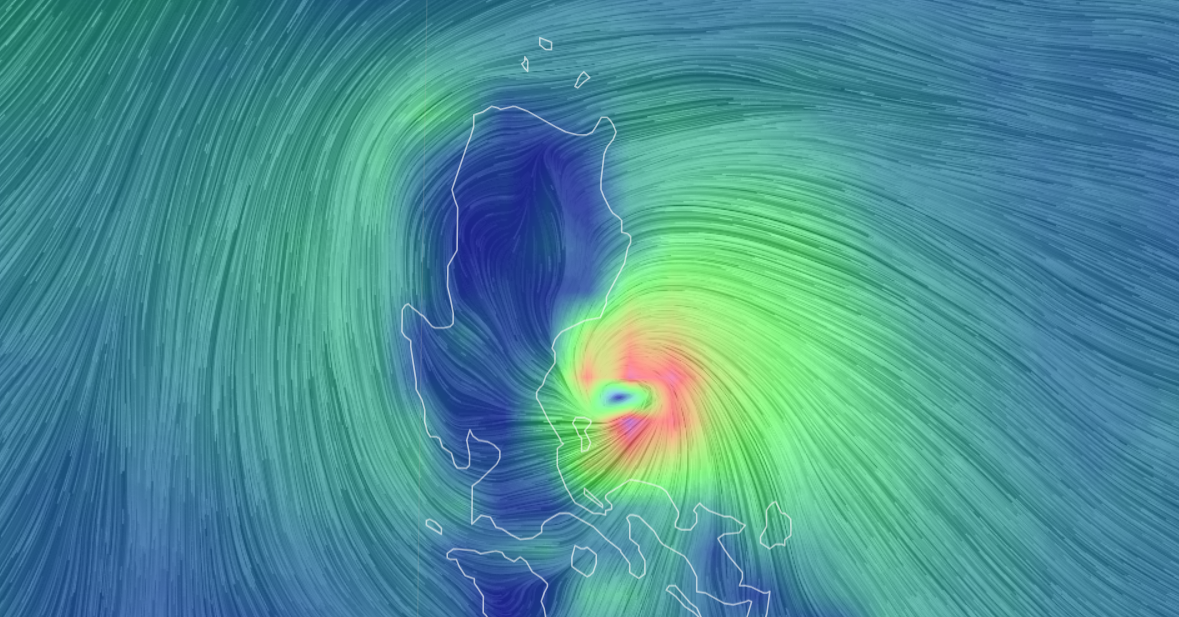
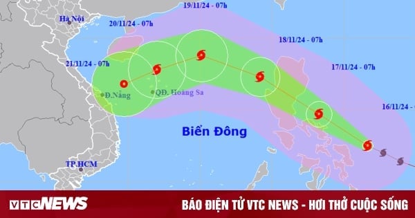
Typhoon Yinxing has strengthened by one level and is approaching the East Sea. According to the National Center for Hydro-Meteorological Forecasting, at 7:00 p.m. on November 6, the eye of the storm was located in the sea northeast of Luzon Island (Philippines). The strongest wind near the eye of the storm was level 14 (150-166 km/h), gusting to level 17. The storm moved west-northwest at a speed of 5-10 km/h.
Forecast in the next 24 hours, the storm in the sea north of Luzon island, moving west northwest, about 10km per hour. The strongest wind near the storm center is level 14, gusting to level 17.
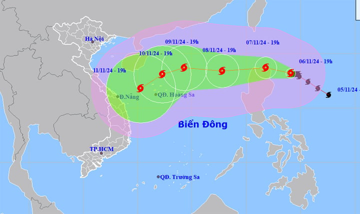
Typhoon Yinxing is currently at level 14, gusting to level 17, and is forecast to make landfall in the East Sea on November 8. (Source: NCHMF)
At around 7:00 p.m. on November 8, the storm changed direction to West Southwest, at a speed of 15-20 km/h, and entered the East Sea, becoming the 7th storm of 2024. The center of the storm was in the East of the North East Sea, 640 km east-northeast of the Hoang Sa archipelago. The strongest wind near the center of the storm was level 13, gusting to level 16.
At 7:00 p.m. on November 9, the storm continued to change direction, moving west-northwest at about 15km per hour. The storm's eye was located in the North East Sea, 320km northeast of the Hoang Sa archipelago. The strongest wind near the storm's eye was level 12, gusting to level 14.
From the next 72 to 120 hours, the storm is likely to change direction, moving in the West Southwest direction, traveling 10-15km per hour, and continuing to weaken.
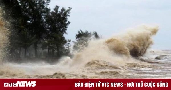
Impact of the storm, the eastern sea area of the North East Sea has strong winds of level 6-7, from the night of November 7 increasing to level 8-10, near the storm's eye level 11-13, gusting to level 16, waves 4-6m high, near the eye 6-8m, rough seas.
To proactively respond to the developments of storms and heavy rains, the Minister of Agriculture and Rural Development requested ministries, branches, and Chairmen of People's Committees of coastal provinces and cities from Quang Ninh to Binh Thuan to closely monitor the developments of the storm; manage means of transport going out to sea; and organize the counting of ships and boats.
Units and localities shall notify owners of vehicles and captains of ships and boats operating at sea of the location, direction of movement and developments of the storm so that they can proactively avoid, escape or not move into dangerous areas.
The provinces in the Central region urgently overcome the consequences of recent floods and storms; check, review, and proactively evacuate people in areas at risk of deep flooding, flash floods, and landslides to safe places.
The Minister also requested localities to check measures to ensure the safety of reservoirs and downstream areas, proactively operate reservoirs to ensure flood capacity according to regulations and be ready to handle possible situations.
Source: https://vtcnews.vn/bao-yinxing-manh-len-cap-14-va-lien-tuc-doi-huong-ar905966.html
![[Photo] Comrade Khamtay Siphandone - a leader who contributed to fostering Vietnam-Laos relations](https://vstatic.vietnam.vn/vietnam/resource/IMAGE/2025/4/3/3d83ed2d26e2426fabd41862661dfff2)

![[Photo] Prime Minister Pham Minh Chinh receives CEO of Standard Chartered Group](https://vstatic.vietnam.vn/vietnam/resource/IMAGE/2025/4/2/125507ba412d4ebfb091fa7ddb936b3b)
![[Photo] Prime Minister Pham Minh Chinh receives Deputy Prime Minister of the Republic of Belarus Anatoly Sivak](https://vstatic.vietnam.vn/vietnam/resource/IMAGE/2025/4/2/79cdb685820a45868602e2fa576977a0)
![[Photo] General Secretary To Lam receives Russian Ambassador to Vietnam](https://vstatic.vietnam.vn/vietnam/resource/IMAGE/2025/4/2/b486192404d54058b15165174ea36c4e)


Comment (0)