
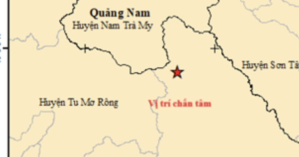
On February 7 (December 28), the Institute of Geophysics recorded 5 consecutive earthquakes occurring in Kon Plong District, Kon Tum.
Accordingly, the first earthquake had a magnitude of 3.7 on the Richter scale, occurring at 10:49 a.m. at the coordinates 14.829 degrees north latitude, 108.273 degrees east longitude (in Kon Plong District). The most recent earthquake was recorded at 11:40 a.m. the same day with a magnitude of 2.8 on the Richter scale, occurring at the coordinates 14.847 degrees north latitude, 108.280 degrees east longitude.

A 4.0 magnitude earthquake was recorded on February 7 in Kon Tum.
INSTITUTE OF GEOPHYSICS
5 consecutive earthquakes occurred in Kon Tum on the 28th of Tet
All five earthquakes occurred within less than an hour. The strongest earthquake had a magnitude of 4.0 on the Richter scale. All five earthquakes had a disaster risk level of 0. There have been no reports of casualties or property damage from the earthquakes.
According to the Department of Industry and Trade of Kon Tum province, experts determined that the earthquake that occurred in Kon Plong district was a stimulated earthquake. The cause of this situation was the accumulation and discharge of water from hydroelectric reservoirs. To date, Kon Tum province has installed 8 earthquake monitoring stations at Thuong Kon Tum hydroelectric plant and Dak Drinh hydroelectric plant (Kon Plong district).
Source link
![[Photo] Closing of the 11th Conference of the 13th Central Committee of the Communist Party of Vietnam](https://vstatic.vietnam.vn/vietnam/resource/IMAGE/2025/4/12/114b57fe6e9b4814a5ddfacf6dfe5b7f)

![[Photo] Overcoming all difficulties, speeding up construction progress of Hoa Binh Hydropower Plant Expansion Project](https://vstatic.vietnam.vn/vietnam/resource/IMAGE/2025/4/12/bff04b551e98484c84d74c8faa3526e0)


Comment (0)