
According to the National Center for Hydro-Meteorological Forecasting, today (June 22), the mountainous areas of the North, South Central, Central Highlands and South will have showers and thunderstorms, with some places having heavy to very heavy rain. The rainfall from 7am to 3pm was over 60mm in some places such as: Nam Xe (Lai Chau) 69.2mm, Quang Ngan (Ha Giang) 77.4mm, An Tuong Tay (Binh Dinh) 103.9mm, Dak Rla (Dak Nong) 66.4mm, Vien An Dong (Ca Mau) 116mm.
It is forecasted that from this evening and tonight to tomorrow night (June 23), in the Central Highlands and the South, there will continue to be moderate rain, heavy rain and thunderstorms, locally very heavy rain with common rainfall from 30-70mm, some places over 150mm. The heavy rain will mainly be concentrated in the afternoon and at night.
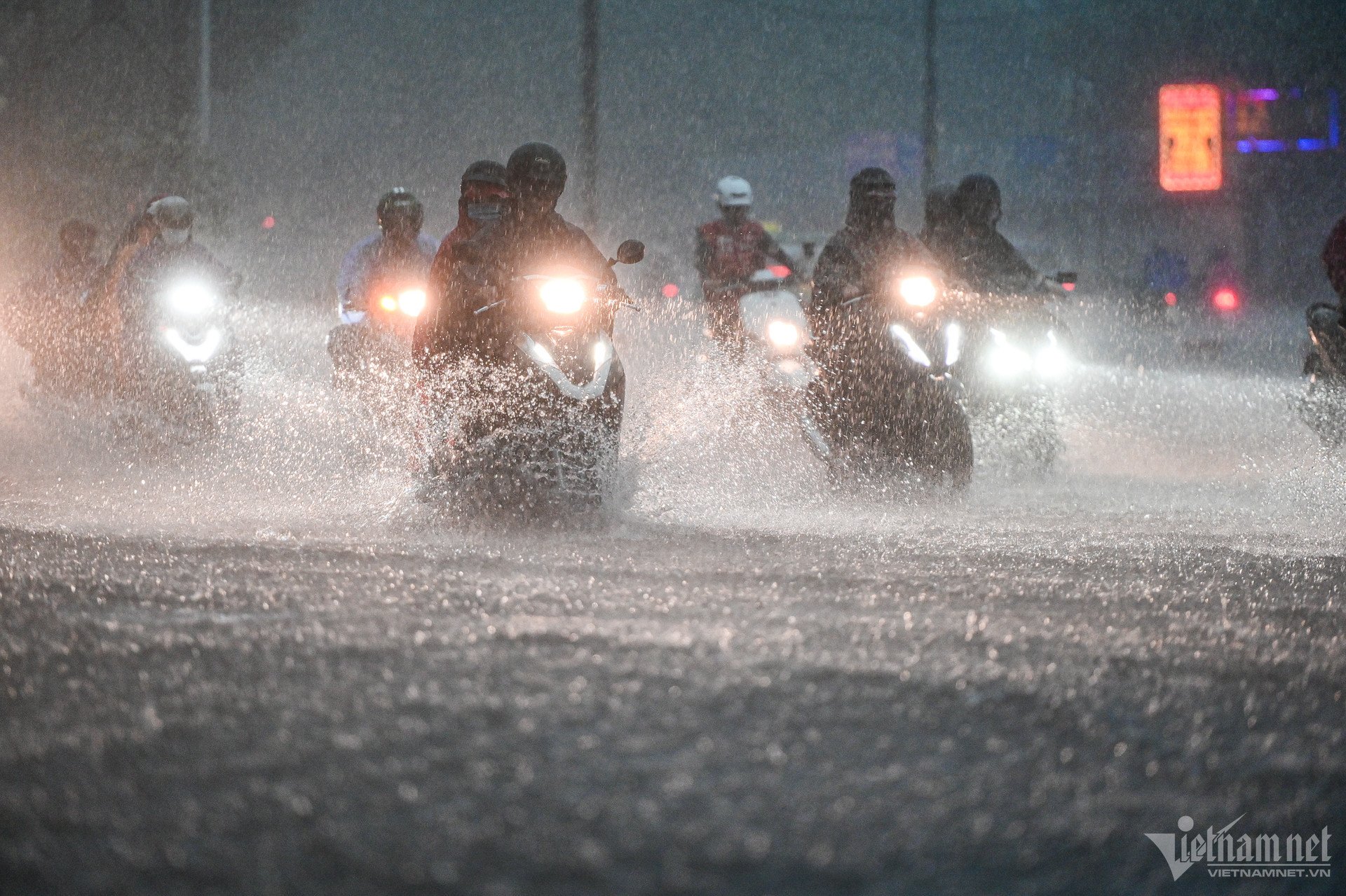
In addition, this evening and tonight, the Northern and Central regions will also have scattered showers and thunderstorms, locally heavy rain with rainfall from 15-30mm, some places over 80mm.
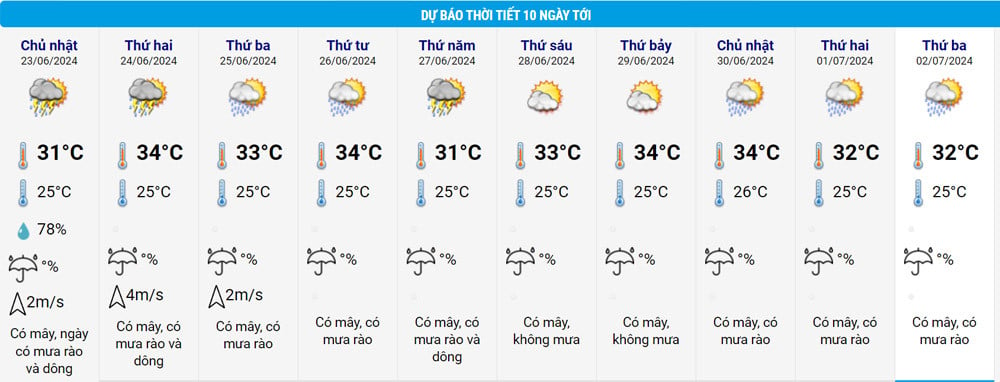
From the night of June 23, the Northwest region will have scattered showers and thunderstorms. From the night of June 24-27, the North and North Central regions are likely to have heavy rain. From the night of June 24-26, the Central Central region will have scattered showers and thunderstorms, with some areas having heavy to very heavy rain.
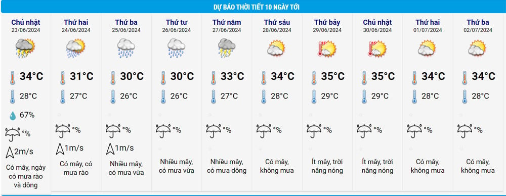
For Ho Chi Minh City, the South and the Central Highlands, due to the influence of the southwest monsoon, there will continue to be moderate rain, some places will have heavy to very heavy rain and scattered thunderstorms. From June 24, heavy rain in the area is likely to gradually decrease, maintaining scattered showers and thunderstorms in the late afternoon and evening.
Also today, the Southern Hydrometeorological Station assessed the main weather patterns affecting the region. Specifically, in the next 1-2 days, the low pressure trough with an axis at about 24-27 degrees latitude connecting with the hot low pressure area in the West will gradually fill up.
Above, the subtropical high pressure over the Central region weakens and slowly retreats to the East. Forming a high-altitude wind convergence zone in the Southern region.
The low pressure trough with its axis passing through the South Central region tends to gradually lift its axis to the North, combined with the southwest monsoon that tends to gradually become stronger.
It is forecasted that in the next 3-10 days, the low pressure trough with its axis passing through the Central Central region connecting with the low pressure area in the Central East Sea will gradually lift its axis to the North and is likely to become stronger. The southwest monsoon will operate at medium to strong intensity.
Above, the subtropical high pressure has stable intensity, then moves back to the West and lifts its axis to the North, weakens in the last 2-3 days and slowly recedes to the East.
The above patterns affect the weather in Ho Chi Minh City and the Southern region, with continuous rain with a probability of 70-75% in the coming time.
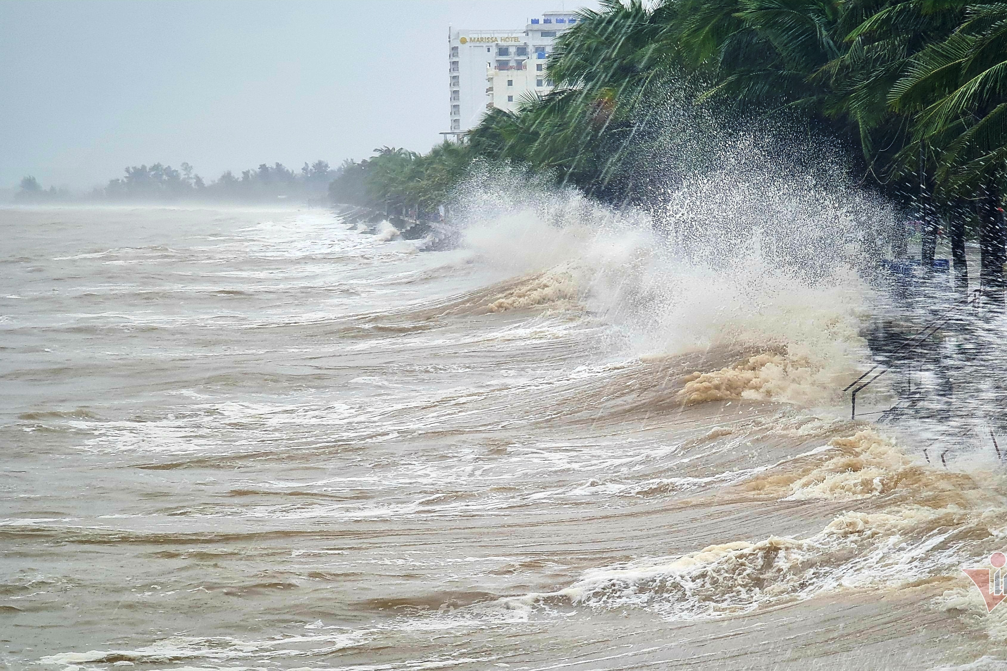
The Meteorological Agency warns that thunderstorms may cause lightning, hail and strong gusts of wind. Beware of the risk of flash floods, landslides in mountainous areas and flooding in low-lying areas. Heavy rain in a short period of time can also cause flooding in urban areas.
Source: https://vietnamnet.vn/tphcm-va-nam-bo-mua-lon-cao-diem-2-ngay-cuoi-tuan-2294183.html


![[Photo] Prime Minister Pham Minh Chinh receives Mr. Jefferey Perlman, CEO of Warburg Pincus Group (USA)](https://vstatic.vietnam.vn/vietnam/resource/IMAGE/2025/4/18/c37781eeb50342f09d8fe6841db2426c)


![[UPDATE] April 30th parade rehearsal on Le Duan street in front of Independence Palace](https://vstatic.vietnam.vn/vietnam/resource/IMAGE/2025/4/18/8f2604c6bc5648d4b918bd6867d08396)


Comment (0)