
Cold air will spread more strongly, around January 28-29 (December 29 and the first day of Lunar New Year), the weather in Ho Chi Minh City will be cold at night and early morning, the lowest temperature in some places will be below 20 degrees.
This morning (January 26, December 27), the National Center for Hydro-Meteorological Forecasting said that cold air has affected most places in the North and some places in the North Central region; in the Gulf of Tonkin, there are strong northeast winds of level 8, gusting to level 9.
According to the Southern Hydrometeorological Station, today the weather in the region is cloudy, sunny during the day, no rain at night; northeast wind level 2-3; lowest temperature 22-25 degrees, highest 29-32 degrees, some places over 32 degrees.
It is forecasted that today and tomorrow (December 27-28), the continental cold high pressure (cold air) will be strengthened to the South. Above, the subtropical high pressure over the South Central - South regions will be active.
It is forecasted that in the next 10 days, the cold air will continue to strengthen to the South, then stabilize and gradually weaken. It is likely to strengthen again around February 2-3. Northeast winds will operate at medium to strong intensity over the Southeast sea.

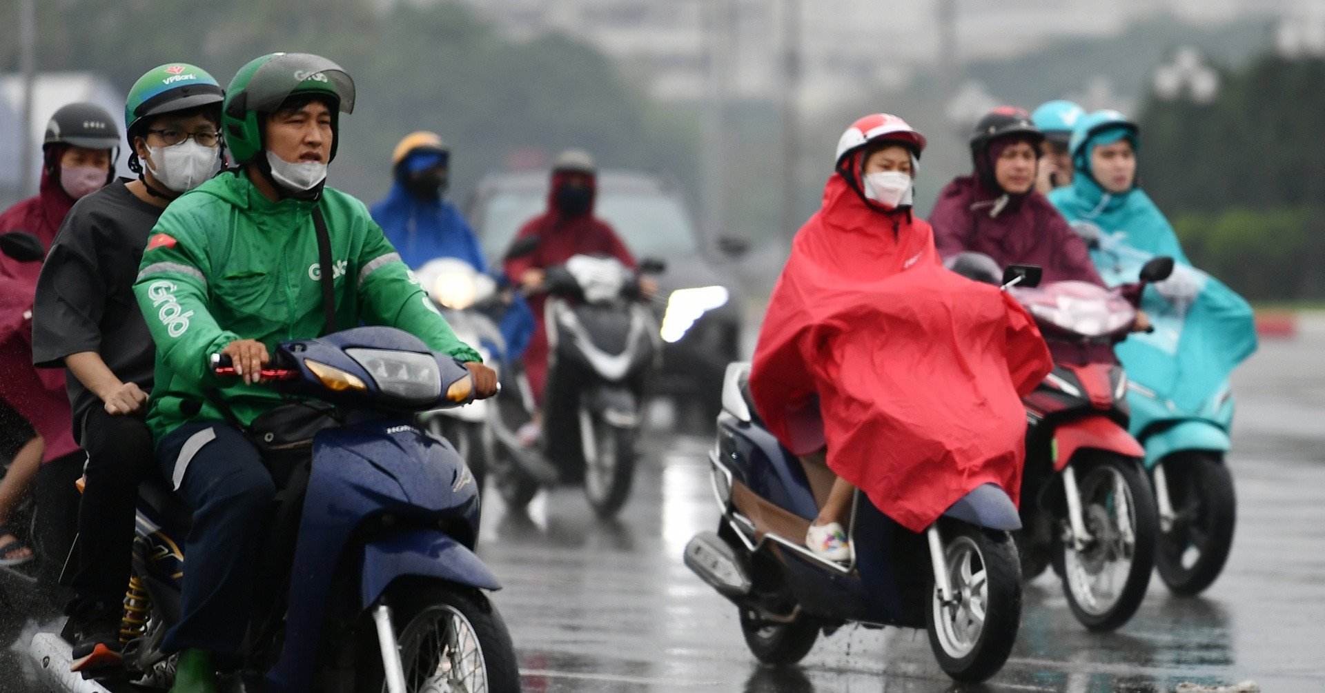
Due to the influence of cold air , around January 28-29 (December 29 and the first day of Tet), the weather in Ho Chi Minh City will be cold at night and early morning. The lowest temperature is 20-21 degrees, with some places in the Eastern region below 20 degrees. In addition, from now until Tet, there is a possibility of fog appearing for a few days.
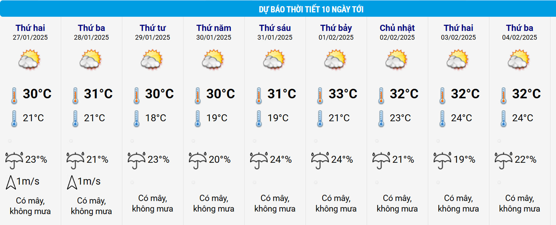
According to the temperature table of the National Center for Hydro-Meteorological Forecasting, on New Year's Eve (January 28), the weather in Ho Chi Minh City will be at its lowest at 21 degrees and will continue to drop to 18-19 degrees on the first and third days of Tet (January 29-31).
Meanwhile, the daytime temperature in the area differs by more than 10 degrees, at 30-31 degrees and is warm and sunny, very favorable for people to travel to celebrate Tet.
In addition, the Southern Hydrometeorological Station also said that during the Lunar New Year, low-lying areas, riverside areas, canals and ditches in Ho Chi Minh City are likely to be flooded due to high tides.
Accordingly, in the coming days, the water level at most stations in the downstream area of the Saigon - Dong Nai River will rise rapidly, combined with strong northeast winds of level 5, sometimes level 6, gusting to level 7, sometimes level 8. Therefore, the highest peak tide level of the day reaching approximately level 1 is likely to appear from January 29 (ie the first day of Tet).
The meteorological station noted that high water levels could cause flooding in low-lying areas, riverbanks and some roads in the city such as Huynh Tan Phat, Tran Xuan Soan (District 7), Le Van Luong, Dao Su Tich, Pham Huu Lau (Nha Be District) and National Highway 50 (Binh Chanh District)...
Flooding caused by high tides can affect traffic and socio-economic development.

Cold air hits, the North is cold since the 27th of Tet, the South on New Year's Eve is only 20 degrees

Hanoi weather for the next 3 days: Mild sunshine to 24 degrees then welcome strong cold air
Source: https://vietnamnet.vn/tphcm-bat-ngo-don-tet-trong-khong-khi-lanh-20-do-2366836.html


![[Photo] Overcoming all difficulties, speeding up construction progress of Hoa Binh Hydropower Plant Expansion Project](https://vstatic.vietnam.vn/vietnam/resource/IMAGE/2025/4/12/bff04b551e98484c84d74c8faa3526e0)


![[Photo] Closing of the 11th Conference of the 13th Central Committee of the Communist Party of Vietnam](https://vstatic.vietnam.vn/vietnam/resource/IMAGE/2025/4/12/114b57fe6e9b4814a5ddfacf6dfe5b7f)


Comment (0)