The content is mentioned in the decision on the plan to mobilize children to attend classes and enroll students at the beginning of the 2025-2026 school year issued by the Ho Chi Minh City People's Committee on March 28.
Specifically, in the 2025-2026 school year, the city continues to require the Department of Education and Training to build enrollment areas based on 3 factors:
Local school allocation, number of children of admission age; Information on students' "current residence" from the industry database. At the same time, use the city's shared GIS digital map system to calculate the travel distance of students, not allocated according to ward administrative boundaries, to create conditions for students to study near their current residence and in accordance with the local reality.
First graders in Ho Chi Minh City on the first day of school for the 2024-2025 school year. (Illustration: Ha Pham)
For schools located on local borders, the Admissions Steering Committee needs to develop appropriate admission plans, creating favorable conditions for students to study in the nearest place.
Enrollment registration is done online at https://tuyensinhdaucap.hcm.edu.vn, through the student's identification code and in compliance with the instructions of the Department of Education and Training. The information used in enrollment is guaranteed to be 100% extracted from the city's education database system.
Admission objects are divided into 2 types, including:
+ Subject 1: priority admission for the following cases:
For grade 1: students have a "current residence" in the area and are within the prescribed age;
For grade 6: students whose "current residence" is in the area, have completed primary school and are within the prescribed age.
+ Subject 2: Students who wish to study in an area other than their actual residence.
For subject 2, the Thu Duc City Primary Admissions Steering Committee and districts need to issue documents clearly defining the subjects that are given priority for admission, creating a legal basis for classification.
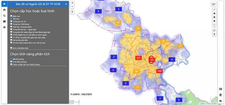
What is primary school admission based on GIS map?
In 2023, the Geographic Information System (GIS) will be applied by Ho Chi Minh City in pilot primary school enrollment in District 8, Tan Binh and Thu Duc City.
Based on education sector data and referring to GIS maps, the district admissions committee will allocate seats based on the principle that students can study as close to home as possible, not just by residential area as before.
In the 2024-2025 school year, the Ho Chi Minh City Department of Education and Training will expand the application of this GIS system to all localities. However, depending on the actual situation in the locality, districts can apply GIS as a support tool alongside other methods, with the goal of helping students attend the school closest to their place of residence.
According to Znews magazine, according to National Geographic, GIS map stands for geographic information system. This system collects, stores, checks and displays data related to locations on the Earth's surface. GIS can display many different types of data on maps such as streets, buildings...
The GIS map of the Ho Chi Minh City Department of Education and Training helps parents analyze school density according to administrative boundaries, purple is low density, yellow is high density, from there they decide to submit their application for admission. (Photo: VOV.VN)
Location on a GIS map can be represented in many forms such as latitude, longitude, address, ZIP code. This system can store a lot of data about people such as population, roads, power lines, schools, factories...
The advantage of the GIS map provided by the Department of Education and Training of Ho Chi Minh City is that parents can search for schools along the route (for example, along the way to work) and find the shortest route, at the same time, filter educational facilities by grade level and type such as primary school, nursery group, preschool class...
When Ho Chi Minh City applies GIS maps in primary school enrollment, parents can choose schools near their homes (can choose inter-ward or inter-district schools) instead of having to send their children to schools in the ward corresponding to their residence. This new enrollment method also limits the situation of parents running to schools outside their area for their children.
When looking up GIS maps, users can analyze field density according to administrative boundaries. Specifically, purple on the map corresponds to low field density, yellow represents high field density.
The advantage of the GIS map provided by the Department of Education and Training of Ho Chi Minh City is that parents can search for schools along the route (for example, along the way to work) and find the shortest route, while filtering educational facilities by grade level and type such as primary schools, nursery groups, preschool classes, etc.
Phuong Nam (Synthesis)
Source: https://vtcnews.vn/tp-hcm-tuyen-sinh-lop-1-lop-6-khong-phan-bo-theo-dia-gioi-phuong-ar935095.html



![[Photo] Prime Minister Pham Minh Chinh chairs meeting after US announces reciprocal tariffs](https://vstatic.vietnam.vn/vietnam/resource/IMAGE/2025/4/3/ee90a2786c0a45d7868de039cef4a712)
![[Photo] A brief moment of rest for the rescue force of the Vietnam People's Army](https://vstatic.vietnam.vn/vietnam/resource/IMAGE/2025/4/3/a2c91fa05dc04293a4b64cfd27ed4dbe)
![[Photo] Ho Chi Minh City speeds up sidewalk repair work before April 30 holiday](https://vstatic.vietnam.vn/vietnam/resource/IMAGE/2025/4/3/17f78833a36f4ba5a9bae215703da710)
![[Photo] Prime Minister Pham Minh Chinh chairs the first meeting of the Steering Committee on Regional and International Financial Centers](https://vstatic.vietnam.vn/vietnam/resource/IMAGE/2025/4/3/47dc687989d4479d95a1dce4466edd32)
![[Photo] General Secretary To Lam receives Japanese Ambassador to Vietnam Ito Naoki](https://vstatic.vietnam.vn/vietnam/resource/IMAGE/2025/4/3/3a5d233bc09d4928ac9bfed97674be98)










Comment (0)