
On the evening of November 24, the Steering Committee for Natural Disaster Prevention and Search and Rescue of Thua Thien - Hue province issued a warning that heavy rain could cause flooding in low-lying areas, and possibly flash floods and landslides in mountainous areas and along rivers and streams.
Specifically, the mountainous areas and the upper reaches of major rivers in Thua Thien - Hue are currently experiencing very heavy rain. The rainfall measured at 5:00 p.m. on November 24 at Bach Ma peak (Phu Loc district) was 652.4mm; Huong Son (Nam Dong district) 246.8mm; Khe Tre town 220.8mm.
According to the forecast of the Hydrometeorological Station of Thua Thien - Hue province, in the next hours, heavy rain will continue in the mountainous areas of Nam Dong and A Luoi districts. Heavy rain in the upstream will cause the water level in reservoirs and hydropower plants in Thua Thien - Hue to be high and the flow of water to the downstream must be increased.
Of which, Ta Trach Lake (the largest reservoir in Thua Thien - Hue province) has been regulating water to the downstream since 10:00 a.m. on November 24 with a gradually increasing flow of about 200-500 m3/s.
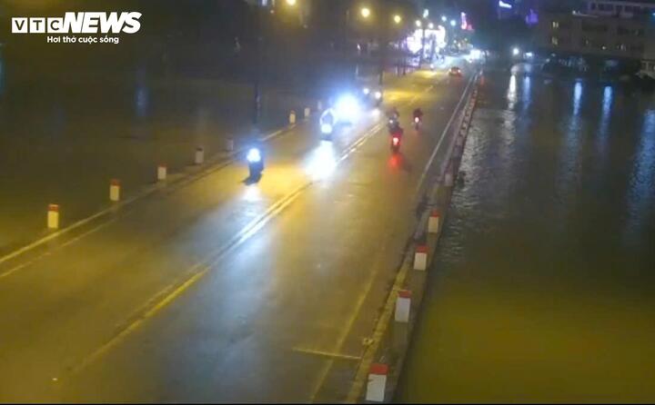
The Steering Committee for Flood and Storm Prevention and Control of Thua Thien - Hue province warned that the water level of the Huong River may rise above alert level 2. (Illustration photo)
According to VTC News reporters in Hue City, there is currently no rain in the downstream areas of the Huong River and the Bo River. However, due to heavy rains upstream and reservoirs regulating water to the downstream, the Steering Committee for Natural Disaster Prevention and Search and Rescue of Thua Thien - Hue Province has warned that the water level on the Huong River will rise above alert level 2 (2 meters) and overflow the rock dam; the Bo River will rise above alert level 2 (3 meters).
The Steering Committee for Natural Disaster Prevention and Search and Rescue of Thua Thien - Hue province recommends that localities and people proactively deploy evacuation plans; regularly monitor flood forecasts to proactively prevent. All vehicles and people are prohibited from traveling through routes with high to very high risk of landslides and underground areas, overflows, bridges and culverts with fast-flowing water, and flooded roads.
The unit also requested local authorities to place warning signs and arrange security forces for people and vehicles; be ready to evacuate people in key locations at risk of flash floods, landslides, and flooding according to the "four on-site" motto.
According to the National Center for Hydro-Meteorological Forecasting, in the past 24 hours (from 7:00 p.m. on November 23 to 7:00 p.m. on November 24), the provinces from Thua Thien - Hue to Phu Yen had moderate rain, heavy rain, and very heavy rain in some places such as: Bach Ma 713mm (Thua Thien Hue); Ba Na 267mm (Da Nang); Tra Don 320mm (Quang Nam); Ba Dien 357mm (Quang Ngai); An Tuong 215mm (Binh Dinh); Song Hinh4 141mm (Phu Yen) ...
In the next 3-6 hours, the above provinces will continue to have rain, with accumulated rainfall ranging from 20-40mm, in some places over 70mm.
Around the evening and night of November 25, strong cold air will affect the northeastern provinces, then the North Central, Northwest and Central Central regions. Northeast winds inland will be strong at level 3-4, coastal areas at level 4-5.
From November 26, the weather in the North and North Central regions will turn cold, with some mountainous areas experiencing severe cold. From the night of the same day, the weather in the North and North Central regions will turn cold, with some mountainous areas experiencing severe cold.
The lowest temperature in this cold air mass in the North and North Central regions is commonly 16-18 degrees Celsius, in mountainous areas 12-14 degrees Celsius, and in high mountainous areas below 10 degrees Celsius.
NGUYEN VUONG

![[Photo] Prime Minister Pham Minh Chinh meets with King Philippe of Belgium](https://vstatic.vietnam.vn/vietnam/resource/IMAGE/2025/4/1/be2f9ad3b17843b9b8f8dee6f2d227e7)
![[Photo] President Luong Cuong and King Philippe of Belgium visit Thang Long Imperial Citadel](https://vstatic.vietnam.vn/vietnam/resource/IMAGE/2025/4/1/cb080a6652f84a1291edc3d2ee50f631)
![[Photo] General Secretary To Lam receives King Philippe of Belgium](https://vstatic.vietnam.vn/vietnam/resource/IMAGE/2025/4/1/e5963137a0c9428dabb93bdb34b86d7c)
![[Photo] Close-up of Vietnam's sniffer dog team searching for earthquake victims in Myanmar](https://vstatic.vietnam.vn/vietnam/resource/IMAGE/2025/4/1/d4949a0510ba40af93a15359b5450df2)


![[Photo] Myanmar's capital in disarray after the great earthquake](https://vstatic.vietnam.vn/vietnam/resource/IMAGE/2025/4/1/7719e43b61ba40f3ac17f5c3c1f03720)


Comment (0)