
Giant barcode-like symbols embossed on asphalt in the United States were used in the 20th century to calibrate the lenses of cameras on airplanes and satellites.
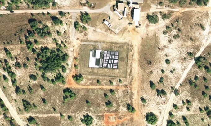
A barcode-like symbol used for optical calibration near Eglin Air Force Base. Photo: GoogleEarth
Most of the symbols were created in the 1950s and 1960s as the Cold War heated up and the United States sought to strengthen its aerial reconnaissance technology, according to IFL Science . When viewed up close on the ground, the symbols are thick layers of black or white paint on a flat concrete or asphalt surface. They are typically smaller than a basketball court and consist of a series of organized barcode-like lines that help aircraft and satellites calibrate the optical resolution of their imaging equipment.
The symbol system serves as an optometrist’s vision chart, where the smallest possible clusters of characters mark the limits of resolution available to optical equipment, according to the Center for Land Use Interpretation (CLUI). For aerial photography, it provides a basis for testing, calibrating, and focusing cameras moving at different speeds and altitudes. Satellites do the same.
CLUI says the barcodes were likely used during testing of some of the most formidable aircraft developed by the US during the Cold War, including the SR-71 Blackbird and the U-2. Today’s technology doesn’t require such calibration, making these giant barcodes redundant. But there are still dozens of barcodes scattered across the US, many near air bases.
Some examples are the barcode symbols near Eglin Air Force Base in Florida, Nevada Test Site, Fort Huachuca in Arizona, Wright-Patterson Air Force Base in Ohio, Travis Air Force Base in California, Beaufort Air Force Station and Shaw Air Force Base in South Carolina.
In 2011, a square or zigzag symbol was also discovered in the middle of the Chinese desert via Google Maps, most likely related to the country's reconnaissance satellites.
An Khang (According to IFL Science )
Source link

![[Photo] Closing of the 11th Conference of the 13th Central Committee of the Communist Party of Vietnam](https://vstatic.vietnam.vn/vietnam/resource/IMAGE/2025/4/12/114b57fe6e9b4814a5ddfacf6dfe5b7f)


![[Photo] Overcoming all difficulties, speeding up construction progress of Hoa Binh Hydropower Plant Expansion Project](https://vstatic.vietnam.vn/vietnam/resource/IMAGE/2025/4/12/bff04b551e98484c84d74c8faa3526e0)


Comment (0)