
On the morning of October 27, Deputy Prime Minister Tran Hong Ha chaired an online meeting with 8 localities from Ha Tinh to Kontum on response to storm No. 6 in 2024 (international name: TRAMI).
Speaking at the meeting, Deputy Prime Minister Tran Hong Ha emphasized that Storm No. 6 is the first storm this year to affect the Central region and is having complicated developments. The Prime Minister, the Ministry of Agriculture and Rural Development and relevant agencies have issued a telegram directing the focus on storm prevention.
"The Central provinces have prepared very proactively, deployed response at the highest level, seriously and responsibly. Storm No. 6 is likely to affect until the 29th, the rainfall due to the storm's circulation is forecast to be very large and prolonged. Local hydrometeorological stations are requested to update regularly and issue timely warnings to the people," Deputy Prime Minister Tran Hong Ha directed.
A representative of the Ministry of National Defense said that since the storm formed, the unit has mobilized 275,480 people, including more than 80,019 soldiers, 199,461 militiamen, and 12,503 military vehicles of all kinds, ready to respond to this storm.

Deputy Prime Minister Tran Hong Ha chairs a storm response meeting. (Photo: H. Van)
Specifically, Military Region 3 mobilized 51,075 people, 582 cars, boats, and special vehicles. Military Region 4 mobilized 135,781 people, 1,195 cars, boats, and special vehicles. Military Region 5 mobilized 55,163 people, 1,660 cars, boats, and 3 airplanes. The Air Defense - Air Force mobilized 4,600 people, 206 vehicles, and 8 airplanes. Army Corps 18 mobilized 30 people, 2 helicopters, and 4 cars.
At the meeting, Mr. Mai Van Khiem, Director of the National Center for Hydro-Meteorological Forecasting, said that at 7:00 a.m. the same day, the center of the storm was 75km from Da Nang, with winds of level 9-10, gusting to level 12, moving west at a speed of 20km/h. Due to the impact of storm No. 6, winds of level 8, gusting to level 10 were recorded on Con Co Island (Quang Tri).
"Storm Tra Mi is different from usual. This storm will make landfall in the southern Quang Tri to northern Quang Nam area and then turn towards the East Sea, weakening into a tropical depression. Therefore, strong winds at sea will last until tomorrow night - October 28," said Mr. Mai Van Khiem.
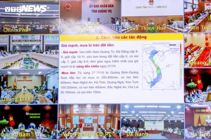
Strong winds and heavy rains are forecast on land related to storm No. 6. (Screenshot of online meeting)
According to Mr. Khiem, the rainfall will last from October 27 to the next 2-3 days. Specifically, it is forecasted that in Quang Binh - Quang Nam, the rainfall will be from 200 - 400mm, in some places up to 600mm; in the southern areas of Nghe An, Ha Tinh, Quang Ngai, Kon Tum, the rainfall will be from 150 - 250mm, in some places over 400mm; in the northern areas of Nghe An, Gia Lai, the rainfall will be from 50 - 100mm, in some places over 150m.
"From Quang Binh to Quang Ngai, there will be over 30 districts and urban areas with a total of 365 communes at risk of flooding," the Director of the National Center for Hydro-Meteorological Forecasting warned.
Regarding flash floods and landslides, due to the characteristics of widespread, prolonged rain and relatively large rainfall, there is a high to very high risk of flash floods and landslides.
According to the latest update report from the National Center for Hydro-Meteorological Forecasting, on the morning of October 27, storm No. 6 is in the sea area of South Quang Tri - Da Nang. The sea area of provinces from Quang Binh to Quang Ngai (including Con Co, Ly Son, and Cu Lao Cham islands) has winds of level 6-7, near the storm center is strong at level 9-10, gusting to level 12. Waves are 2-4 m high, near the storm center are 4-6 m high. The sea is very rough. The coastal areas of Quang Binh-Quang Tri and Quang Ngai-Binh Dinh have waves of 2-4 m high; in the Hue-Quang Nam area, waves are 3-5 m high.
It is forecasted that at noon on October 27, storm No. 6 will make landfall in the southern Quang Tri-Da Nang area. The area near the storm will have strong winds of level 8-9, gusting to level 11. The coastal areas of Quang Tri, Thua Thien Hue, and Da Nang will have strong winds of level 8-9, gusting to level 10-11; further inland, there may be strong winds of level 6-7, gusting to level 8-9. The most dangerous time for strong winds is from the morning of October 27 to the afternoon of October 27.
In the next 12-24 hours, the storm will move eastward, move back to the sea, weaken into a tropical depression, then a low pressure area and gradually dissipate.
Source: https://vtcnews.vn/quan-doi-huy-dong-hon-275-000-nguoi-ung-pho-bao-trami-ar904104.html


![[Photo] Closing of the 11th Conference of the 13th Central Committee of the Communist Party of Vietnam](https://vstatic.vietnam.vn/vietnam/resource/IMAGE/2025/4/12/114b57fe6e9b4814a5ddfacf6dfe5b7f)
![[Photo] Overcoming all difficulties, speeding up construction progress of Hoa Binh Hydropower Plant Expansion Project](https://vstatic.vietnam.vn/vietnam/resource/IMAGE/2025/4/12/bff04b551e98484c84d74c8faa3526e0)


Comment (0)