
(Dan Tri) - Circular 56/2024 of the Ministry of Finance specifically stipulates the collection rates, collection, payment, management and use of fees for exploiting and using land documents from the National Land Information System.
Clause 36, Article 3 of the 2024 Land Law stipulates: "Land use planning is the allocation and zoning of land according to the space of use for the goals of socio-economic development, national defense, security, environmental protection and climate change adaptation based on land potential and land use needs of sectors and fields for each socio-economic region and administrative unit within a specified period of time".
Planned land can be understood as land area under planning, plans to implement projects, roads, other public works or to be recovered for defense and security purposes. Land plots in this case will mainly be recovered according to the provisions of law.
Land in planning will have some rights restricted to land users. Therefore, it is very important to check whether the land is in planning or not before buying.
Currently, one of the ways to know whether a plot of land is included in the planning or not is to request information from the Land Registration Office. People can exploit the land information system provided by the State by requesting forms and paying fees. Another way is to look up planning information online from the national land information system that is about to be launched.

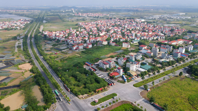
Land plots auctioned in Hanoi (Photo: Duong Tam).
According to the Land Law 2024, the Ministry of Natural Resources and Environment is the agency responsible for managing, operating, maintaining, and upgrading the software of the national land information system.
This agency focuses on directing, urging, and guiding localities to accelerate the completion of land databases to ensure that by 2025, local land databases will be completed to integrate data into the upcoming national land database.
Regarding the cost of viewing land use planning maps, in Section III, Appendix I attached to Circular 56/2024, the Ministry of Finance stipulates the cost of viewing documents as follows.
To look up the first or last land use plan map for the district level, the fee is 1 million VND, for the provincial level it is 2 million VND, for the national level or the socio-economic region map the fee is 4 million VND.
This fee is calculated when viewing a Vector digital map (without reducing image quality). If it is a Raster image (geoPDF, PDF, geoTIFF, TIFF, EPS, ECW, JPG), the fee is 50% of the fee for a Vector map of the same scale.
For annual land use planning maps at district level, the search fee is 1 million VND.
For spatial data of land use planning for the first/last period at district level, the fee is 200,000 VND, for provincial level it is 400,000 VND, for national level and socio-economic region data the fee is 800,000 VND.
For searching annual land use planning spatial data with district-level data layer, the fee is 200,000 VND.
If people need to look up documents or data sets on the first period land use plan; the last period land use plan; the last period land use plan approval; the land use plan adjustment; the annual land use plan (by period), the fee for a scanned document page or a digital document page is 8,200 VND/page. The fee applied to the first 5 document pages is 8,200 VND, from the 6th page onwards is 900 VND.
Source: https://dantri.com.vn/bat-dong-san/muc-phi-de-xem-quy-hoach-su-dung-dat-la-bao-nhieu-20241126135718202.htm


![[Photo] Prime Minister Pham Minh Chinh visits comrade Khamtay Siphandone](https://vstatic.vietnam.vn/vietnam/resource/IMAGE/2025/4/4/a570cc01b32d458bb9702983e78e193a)


![[Photo] Many advanced technologies gather at Analytica Vietnam 2025](https://vstatic.vietnam.vn/vietnam/resource/IMAGE/2025/4/4/0ef01117275d4d71b2e2a45c215ac2f8)


Comment (0)