
Faced with the situation of riverbank and coastal erosion in recent years, the People's Committee of Quang Tri province has issued a project to respond to riverbank and coastal erosion in response to climate change in Quang Tri province in the period of 2018 - 2020, with a vision to 2030, with appropriate groups and solutions, with priority arrangements according to the level of danger and each stage.

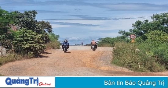
The sea embankment of Vinh Moc, Kim Thach commune, Vinh Linh district has been repaired, creating peace of mind for people living along the coast - Photo: LA
On that basis, focus on researching, investigating, and evaluating the current situation; analyzing the causes, selecting specific solutions for each stage and each area to ensure feasibility, synchronization and sustainability in order to thoroughly and effectively handle the situation of riverbank and coastal erosion, minimize damage and stabilize people's lives in the long term in the face of increasingly complex climate change.
Specifically, from 2021 to present, despite the limited provincial budget, resources have been mobilized to invest in the construction of more than 66 km of embankments to prevent landslides along river banks and coastlines, combined with serving the needs of people's traffic, improving the environment, and urban embellishment in accordance with the local socio-economic development plan, with a total cost of more than 872 billion VND.
Such as the projects: embankment to prevent erosion on the O Lau river bank, emergency embankment to prevent erosion on the upstream of both banks of Thac Ma river, Hai Lang district with a length of nearly 9.3 km, total cost of more than 82.1 billion VND; embankment of Hieu river bank through Cam Thuy commune, Cam Hieu commune, Cam Lo district with a length of 926 m, cost of more than 11.6 billion VND; emergency embankment to prevent erosion on the Thach Han river bank adjacent to DH40a road, Trieu Do commune, Trieu Phong district with a length of 634 m, cost of 7 billion VND; urgent repair and restoration of Ben Hai left embankment with a length of 382 m, cost of 2.3 billion VND.
Regarding coastal protection works, a number of projects have been completed such as: emergency repair of Vinh Moc sea dike, Vinh Thach commune (now Kim Thach commune), Vinh Linh district with a total length of more than 1.8 km, costing 67 billion VND; overcoming landslides of Vinh Thai sea dike, Vinh Linh district with a length of 10 km, costing 50 billion VND...
Dredging and clearing the flow of some drainage axes of silted rivers such as Canh Hom River and Vinh Dinh River. In addition, more than 70 hectares of wave-breaking trees were planted to protect the banks along the river estuaries and sea dykes, including: Thach Han right dyke, Thach Han left dyke, Vinh Thai dyke, Ben Hai left dyke, Ben Hai right dyke.
In general, the work of handling riverbank and coastal erosion in recent times has brought about positive results. Investment in works ensures timely handling in some particularly dangerous areas, protecting the lives and property of the people and the State; many non-structural solutions have been deployed, contributing to improving the capacity and changing the awareness of the community in the work of preventing and combating natural disasters in general and responding to riverbank and coastal erosion in particular; creating a stable mentality for people living along riverbanks and coastal areas in the province.
According to the review of the Department of Agriculture and Rural Development, currently in the province there are about 133.42 km of riverbank and coastal erosion that have not been repaired or handled, including 26.96 km of especially dangerous erosion, 72.97 km of dangerous erosion, and 33.49 km of normal erosion.
In particular, riverbank erosion has developed almost continuously on both sides of the main rivers including the Thach Han, Ben Hai, Thac Ma - O Lau river systems. Depending on the geology, the bank erosion rate is different, the lowest place is from 1 - 2 m/year such as the left and right banks of Thac Ma - O Lau river, Nhung river; the highest place is from 10 m - 15 m/year such as the left and right banks of Thach Han, Hieu river, Ben Hai river. Riverbank erosion has deeply encroached on residential land and cultivated land. Some places have had to relocate houses such as the communes: Trieu Long, Trieu Giang, Trieu Phong district; Hai Le, Quang Tri town.
Riverbank erosion also affects the lives of people in residential areas in districts, towns and cities where people live on both sides of the river with a total of more than 4,520 households living in the affected area. Of these, the number of households currently living in truly dangerous areas, less than 20m from the riverbank, is about 800 households.
Regarding annual coastal erosion during the rainy and stormy season, the reality of the sea encroaching and waves causing coastal erosion affects many coastal residential areas such as the section through Trieu Lang and Trieu Van communes, Trieu Phong district; the section through Trung Giang and Trung Hai communes, Gio Linh district, where the coast is severely eroded, sweeping away business tents and shops along the coast, with the risk of directly affecting residential land and coastal defense routes...
According to Director of the Department of Agriculture and Rural Development Ho Xuan Hoe, in order to respond to the landslide situation in a long-term and effective manner, in the coming time, departments, branches and localities will continue to closely coordinate in disseminating and popularizing legal regulations to raise awareness of organizations, communities and people about preventing and combating riverbank and coastal landslides so that organizations and individuals voluntarily comply.
Inspect and promptly and resolutely handle violations of regulations on protection and use of riverbeds, banks, beaches and coastlines, especially activities of building houses, riverside and riverside works and illegal sand and gravel mining in riverbeds and coastal areas, which increase the risk of riverbank and coastal erosion. Strictly manage the use and development of mangrove ecosystems associated with stabilizing people's livelihoods to limit the degradation of coastal mangrove forests.
Install landslide warning signs; organize the evacuation of households living in areas with landslides, especially areas with particularly dangerous landslides, to ensure the safety of people and property.
Plan to build bank protection works in densely populated areas and important infrastructure that cannot be relocated. Monitor and evaluate the situation of riverbank and coastal erosion and propose fundamental and long-term solutions to landslide areas and areas at risk of landslides in the coming time.
Le An
Source: https://baoquangtri.vn/chu-dong-phong-chong-sat-lo-bo-song-bo-bien-186915.htm


![[Photo] Looking back at the impressive moments of the Vietnamese rescue team in Myanmar](https://vstatic.vietnam.vn/vietnam/resource/IMAGE/2025/4/11/5623ca902a934e19b604c718265249d0)


![[Photo] "Beauties" participate in the parade rehearsal at Bien Hoa airport](https://vstatic.vietnam.vn/vietnam/resource/IMAGE/2025/4/11/155502af3384431e918de0e2e585d13a)


![[Photo] Summary of parade practice in preparation for the April 30th celebration](https://vstatic.vietnam.vn/vietnam/resource/IMAGE/2025/4/11/78cfee0f2cc045b387ff1a4362b5950f)


Comment (0)