
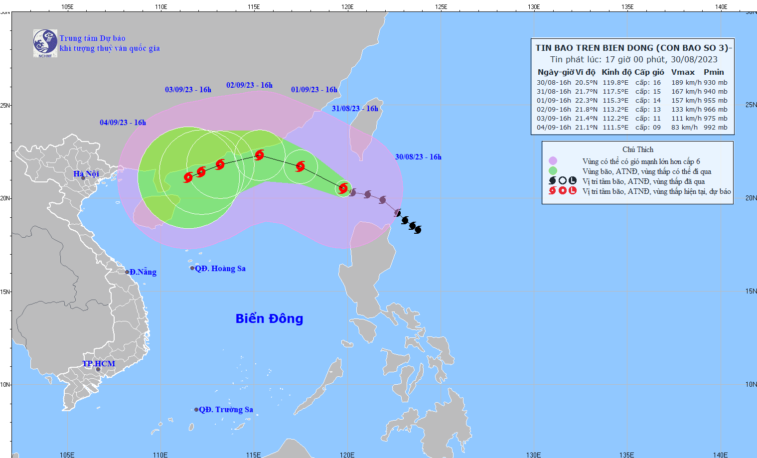
According to the National Center for Hydro-Meteorological Forecasting, at 4:00 p.m. on August 30, the center of storm SAOLA was located at about 20.5 degrees North latitude; 119.8 degrees East longitude, in the northeastern sea of the North East Sea. The strongest wind near the center of the storm is level 15-16 (167-201 km/h), gusting to level 17, moving in a West Northwest direction, at a speed of about 15 km/h.
At 4:00 p.m. on August 31, the storm moved in a West-Northwest direction at a speed of about 10-15 km/h in the northeastern sea area of the North East Sea, about 370 km East-Southeast of Hong Kong (China).
From the next 72 to 120 hours, the storm will move mainly in the West Southwest direction, traveling 5-10 km per hour, with the intensity likely to gradually decrease.
Due to the influence of the storm, the northeastern sea area of the North East Sea has strong storm winds of level 9-10, then increasing to level 11-13, near the storm center level 14-16, gusting above level 17; the sea is very rough.
In the eastern sea of the North East Sea, waves are 4.0-6.0m high, then increase to 8.0-10.0m.
Source
![[Photo] Phuc Tho mulberry season – Sweet fruit from green agriculture](https://vstatic.vietnam.vn/vietnam/resource/IMAGE/2025/4/10/1710a51d63c84a5a92de1b9b4caaf3e5)

![[Photo] Prime Minister Pham Minh Chinh chairs meeting to discuss tax solutions for Vietnam's import and export goods](https://vstatic.vietnam.vn/vietnam/resource/IMAGE/2025/4/10/19b9ed81ca2940b79fb8a0b9ccef539a)

![[Photo] Summary of parade practice in preparation for the April 30th celebration](https://vstatic.vietnam.vn/vietnam/resource/IMAGE/2025/4/11/78cfee0f2cc045b387ff1a4362b5950f)


Comment (0)