
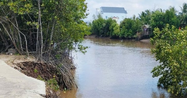
On the morning of July 29, the Phan Thiet - Dau Giay Expressway section through Ham Tan District (near the Phan River intersection, National Highway 55, Binh Thuan) was flooded to a depth of nearly 1 meter, causing the dense traffic on the expressway from both sides to be congested for hours and causing serious traffic jams. The cause was the heavy rain that lasted from the evening of July 28.

The South will continue to have heavy rain in the coming days.
Previously, as reported by Thanh Nien Newspaper, on the evening of July 27, in Bu Dang district (Binh Phuoc), heavy rain continued in many areas such as Duc Phong town, Doan Ket commune and Binh Minh, causing severe flooding, with some places up to 2m deep.
The storm has passed, why is there still heavy rain in the South?
As of the morning of July 29, according to the National Center for Hydro-Meteorological Forecasting, heavy rains occurred in large areas in the Southern region. Typical high rainfall amounts include Tan Dien (Kien Giang) 216.6mm, Thanh Tri (Soc Trang) 183.8mm, Nang Mau (Hau Giang) 125.2mm...
On the afternoon and night of July 29, the Central Highlands and the South continued to have moderate rain, heavy rain and thunderstorms, locally very heavy rain with common rainfall of 20 - 50mm, some places over 100mm. On the day and night of July 30, this area continued to have widespread thunderstorms, locally heavy to very heavy rain with rainfall of 20 - 40mm, some places over 80mm. Warning, in the Central Highlands and the South, there is a possibility of heavy rain lasting for many days to come.
Therefore, people should be on guard against heavy rain in a short period of time causing flooding in urban areas. During thunderstorms, there is a possibility of tornadoes, lightning, hail and strong gusts of wind.
Meanwhile, the central and southern East Sea (including the Truong Sa archipelago), the sea from Binh Thuan to Ca Mau, Ca Mau to Kien Giang will have showers and thunderstorms. At Phu Quy island station, there will be strong southwest winds of level 6, gusting to level 7-8; Phu Quoc and Huyen Tran will have southwest winds of level 5, sometimes level 6, gusting to level 8-9.
From now until the night of July 30, the sea area from Binh Dinh to Ca Mau, the central southern area of the East Sea (including the sea area of Truong Sa archipelago) will have strong southwest winds of level 6, gusting to level 7 - 8, rough seas, and waves 3 - 5m high. "All ships and other activities in the above sea areas are at high risk of being affected by strong winds and big waves," the National Center for Hydro-Meteorological Forecasting noted.
Quick view 12:00 on July 29: Phan Thiet - Dau Giay Expressway is terribly flooded | BlackPink has arrived in Vietnam
According to meteorological experts, the heavy rain in the South continues to last because the southwest monsoon is strong. The reason is that the sea east of the Philippines is experiencing a strong storm. According to the world's forecast models, this storm will not enter the East Sea, but due to its attraction, the southwest monsoon will continue to be strong, causing heavy rain in the coming days.
Source link
![[Photo] Opening of the 44th session of the National Assembly Standing Committee](https://vstatic.vietnam.vn/vietnam/resource/IMAGE/2025/4/14/03a1687d4f584352a4b7aa6aa0f73792)
![[Photo] Touching images recreated at the program "Resources for Victory"](https://vstatic.vietnam.vn/vietnam/resource/IMAGE/2025/4/14/99863147ad274f01a9b208519ebc0dd2)

![[Photo] Children's smiles - hope after the earthquake disaster in Myanmar](https://vstatic.vietnam.vn/vietnam/resource/IMAGE/2025/4/14/9fc59328310d43839c4d369d08421cf3)
![[Photo] General Secretary To Lam chairs the third meeting to review the implementation of Resolution No. 18-NQ/TW](https://vstatic.vietnam.vn/vietnam/resource/IMAGE/2025/4/14/10f646e55e8e4f3b8c9ae2e35705481d)


Comment (0)