
Weather forecast for tomorrow, February 13, 2025, the North will continue to experience severe cold due to the strengthening of cold air. At the same time, a tropical depression is active in the East Sea, causing heavy rain and thunderstorms and strong gusts of wind in the western sea.
According to the National Center for Hydro-Meteorological Forecasting, tomorrow, February 13, a cold air mass will move south and affect our country.
It is forecasted that around the night of February 12 and early morning of February 13, cold air will affect the Northeast region, then affect the North Central region and some places in the Northwest. The wind inland will change to the Northeast at level 2-3, level 3 in coastal areas.
In the North and North Central regions, the weather continues to be cold, with some mountainous areas in the North experiencing severe cold. The lowest temperature during this cold spell in the North is generally 14-17 degrees Celsius, in the highlands 11-13 degrees Celsius, and in some places below 10 degrees Celsius; in the North Central region, it is generally 15-18 degrees Celsius. In Hanoi, it is cold, with the lowest temperature generally 15-17 degrees Celsius.
Due to the influence of cold air strengthening combined with strong currents in the upper westerly wind zone from the night of February 12 to the morning of February 13, the Northeast and North Central regions will have rain and light rain.
Tropical depression in the East Sea
At 1:00 p.m. on February 12, the center of the tropical depression was at about 12.3 degrees North latitude; 112.0 degrees East longitude, in the northwest area of Truong Sa archipelago. The strongest wind near the center of the tropical depression was level 6 (39-49 km/h), gusting to level 8. The tropical depression moved northwest at a speed of 5-10 km/h.
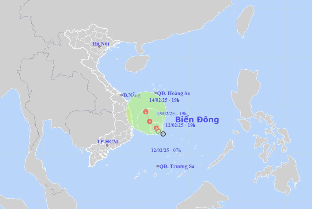
It is forecasted that in the next 48 to 72 hours, the tropical depression will move slowly to the North-Northwest and gradually weaken. The western sea area of the Central East Sea and the southwestern sea area of the North East Sea; the offshore sea area from Binh Dinh to Khanh Hoa will have showers and strong thunderstorms, strong winds of level 6, gusts of level 8, rough seas. The western sea area of the Central East Sea and the southwestern sea area of the North East Sea (including the sea area of Hoang Sa archipelago) will have waves 2.0-3.5m high. From February 14, the offshore sea area from Thua Thien Hue to Binh Dinh will have waves 2.0-3.0m high.
Ships operating in the above mentioned dangerous areas are susceptible to the effects of storms, whirlwinds, strong winds and large waves.
Weather forecast February 13, 2025 in detail for regions across the country:
Northwest
Cloudy, with scattered rain and light rain, with some rain in the Northwest. Light wind. Cold. Lowest temperature: 14-17 degrees Celsius, some places below 13 degrees Celsius. Highest temperature: 18-21 degrees Celsius, with 23-26 degrees Celsius in the Northwest.
Northeast
Cloudy, scattered light rain at night and morning, then rain in some places. Northeast wind level 2-3. Cold weather, some mountainous areas have severe cold. Lowest temperature: 15-18 degrees Celsius, some mountainous areas have places below 15 degrees Celsius. Highest temperature: 18-21 degrees Celsius.
Thanh Hoa - Thua Thien Hue
Cloudy, with scattered light rain at night and morning in the North, followed by rain in some places later; with scattered rain at night in the South, with scattered showers during the day. Light wind. Cold. Lowest temperature: 17-20 degrees Celsius. Highest temperature: 21-24 degrees Celsius.
Da Nang - Binh Thuan
Cloudy, with scattered showers and thunderstorms in some places; in the North, there will be scattered showers, locally with moderate rain, heavy rain and thunderstorms. Northeast to north wind level 2-3. Lowest temperature: North 19-22 degrees Celsius, South 22-24 degrees Celsius. Highest temperature: North 23-26 degrees Celsius, South 27-30 degrees Celsius.
Central Highlands
Cloudy, with scattered showers and thunderstorms. Light wind. Cold at night. Lowest temperature: 18-21 degrees Celsius. Highest temperature: 28-31 degrees Celsius.
Southern Vietnam
Cloudy, no rain at night, sunny during the day. Northeast wind level 2-3. Lowest temperature: 23-26 degrees Celsius. Highest temperature: 30-33 degrees Celsius, some places above 33 degrees Celsius.
Hanoi
Cloudy, rain at night and in the morning, scattered light rain, then rain in some places. Northeast wind level 2-3. Cold. Lowest temperature: 16-18 degrees Celsius. Highest temperature: 19-21 degrees Celsius.
Source: https://vietnamnet.vn/du-bao-thoi-tiet-ngay-mai-13-2-2025-ap-thap-nhiet-doi-tren-bien-dong-2370783.html


Comment (0)