
At 4:00 a.m., the storm center was about 340 km east-southeast of Leizhou Peninsula (China), with the strongest wind speed of 133 km/h, level 11-12, gusting to level 15.
The National Center for Hydro-Meteorological Forecasting said that today and tonight the storm will move west-northwest at a speed of 15-20 km/h and is likely to strengthen. By 4am tomorrow, the storm will be about 190 km east-southeast of Mong Cai (Quang Ninh), about 290 km east of Hai Phong, with the strongest winds at level 11-12, gusting to level 15.
After that, the storm will maintain its direction and intensity and enter the sea area of Quang Ninh - Hai Phong with the strongest wind at level 9-10, gusting to level 12. The storm will continue to move deep into our country's mainland and weaken into a tropical depression in the Northeast region.
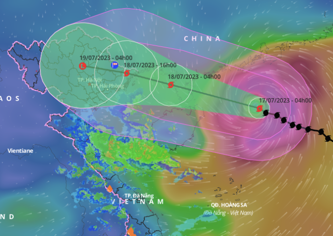
Forecast of direction and affected area of storm Talim, 4am on July 17. Photo: NCHMF
The Japan Meteorological Agency said the storm is about to enter Leizhou with winds of 126 km/h, and will have winds of 108 km/h when it enters the Gulf of Tonkin. The Hong Kong station said the storm will pass through Leizhou with winds of 140 km/h. The center of the storm will move along the Chinese border with Mong Cai City (Quang Ninh), then move deep into the provinces of Cao Bang and Lao Cai before weakening.
From this afternoon, the northern Gulf of Tonkin (including Bach Long Vi and Co To island districts) will have winds gradually increasing to level 6-7, then increasing to level 8-9, near the storm center level 10-11, gusting to level 14.
From early tomorrow morning, coastal areas from Quang Ninh to Nam Dinh will have winds gradually increasing to level 6-7, then increasing to level 8, areas near the storm center will have winds of level 9-10, gusting to level 13; areas deep inland in the Northeast will have strong winds of level 6-7, gusting to level 9.
The northern sea area of the North East Sea has waves 5-7 m high. From tomorrow morning, the northern sea area of the Gulf of Tonkin will have increasing waves, 3-5 m high. The coastal areas of Quang Ninh - Nam Dinh provinces have waves 2-4 m high. The coastal areas of Quang Ninh - Thai Binh provinces have storm surges of 0.5-0.8 m.
From tonight to July 20, the North will have heavy rain with common rainfall of 200-400 mm, locally over 500 mm. Thanh Hoa and Nghe An will have common rainfall of 100-200 mm, locally over 300 mm.
The meteorological agency has warned that heavy rains could cause urban flooding. Heavy rains occurring after many days of thunderstorms and heat waves over the past 10 days combined with rain in the coming days will increase the risk of flash floods and landslides from July 18 in the Northern region, with high risks in the provinces of Quang Ninh, Lang Son, Cao Bang, Ha Giang, Lao Cai, and Yen Bai.
Yesterday, Prime Minister Pham Minh Chinh issued a telegram requesting coastal provinces from Quang Ninh to Nghe An to proactively ban fishing and tourist boats from the sea; evacuate people from weak houses, areas at risk of flooding, and river mouths. In mountainous areas, authorities need to evacuate people from areas at risk of deep flooding, isolation, flash floods, and landslides.
Government leaders asked localities to check their dyke and reservoir systems and prepare rescue equipment and vehicles if necessary. This morning, Deputy Prime Minister Tran Luu Quang will chair a meeting of the National Steering Committee for Natural Disaster Prevention with provinces and cities to discuss storm prevention plans.
Source link


![[Photo] Prime Minister Pham Minh Chinh receives Mr. Jefferey Perlman, CEO of Warburg Pincus Group (USA)](https://vstatic.vietnam.vn/vietnam/resource/IMAGE/2025/4/18/c37781eeb50342f09d8fe6841db2426c)

![[UPDATE] April 30th parade rehearsal on Le Duan street in front of Independence Palace](https://vstatic.vietnam.vn/vietnam/resource/IMAGE/2025/4/18/8f2604c6bc5648d4b918bd6867d08396)


Comment (0)