
Along with Ho Chi Minh City, provinces in the Southeast region have also planned to exploit the space along the Dong Nai River. Many modern, ecological urban projects are gradually taking shape.
Forming many new urban areas
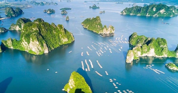
Dong Nai River flows through Dong Nai province (called Cai River) for 200km, through Tan Phu, Dinh Quan, Vinh Cuu districts, Bien Hoa city and Nhon Trach and Long Thanh districts. Of which, the section bordering Dong Nai and Ho Chi Minh City is more than 50km long, convenient for developing economic corridors and exploiting landscapes. Dong Nai province is implementing many urban renovation projects along the Cai River axis through Bien Hoa city to improve urban traffic infrastructure and create riverside landscapes.
Some districts in the province with rivers passing through have also had plans to exploit the riverside landscape, forming new urban areas. A typical example is the construction of two riverside roads with a total investment of 5,200 billion VND, running from Vinh Cuu district - Bien Hoa city - Long Thanh - Nhon Trach, associated with organizing diverse and suitable recreational activities in the riverside area, while restoring cultural and historical resources along the river.
This is also a premise for the development of Vinh Cuu and Nhon Trach districts when there are many projects but the urban value has not been promoted. In particular, the riverside road helps Nhon Trach district connect with route 319, Ho Chi Minh City - Long Thanh - Dau Giay expressway and Ben Luc - Long Thanh expressway. Along with that, Dong Nai has a policy of building Pho island (Hiep Hoa ward, Bien Hoa city) into the core of Bien Hoa urban area with the function of a regional historical, cultural, commercial, financial and ecological center with an area of 293 hectares and an expected population of 31,600 people.
The project has an investment capital of more than 72,200 billion VND, implemented in 12 years (from 2023-2035), with the goal of forming a new urban area, service complex, low construction density, modern, in harmony with the natural landscape, aiming at sustainable tourism development, combining diversification of housing types, combined with public service trade centers. In addition, along the Dong Nai River through Bien Hoa City, Long Thanh and Nhon Trach districts are forming many new urban area projects, entertainment areas, tourist attractions such as Tan Van Islet, Ba Xe Islet, Buu Long Tourist Area, Aqua City Novaland Residential Area 1,085ha, Waterfont Nam Long 170ha (Bien Hoa City), Dai Phuoc Ecological Urban Area 550ha and SwanBay 200ha (Nhon Trach District) ...
Developing riverside ecotourism
In Binh Duong province, the Dong Nai River flows through Tan Uyen City and Di An City. To exploit the advantages of the riverside, Binh Duong province has advocated developing eco-tourism areas and low-density urban areas along this river. Many surveys and assessments of eco-tourism potential have been coordinated by the People's Committee of Tan Uyen City (a locality with many areas surrounded by the Dong Nai River) and are gradually developing eco-tourism landscape routes to attract domestic and foreign tourists.
, opposite Long Phuoc ward, Thu Duc city. Photo: HOANG HUNG")
Tan Uyen City has 6 communes located along the Dong Nai River and Binh Duong Province has soon planned to build infrastructure with riverside roads, put into planning low-density housing, riverside eco-tourism areas concentrated for 2 communes Bach Dang and Thanh Hoi. In these areas, Binh Duong Province will not develop industry, high-density urban areas, retain high-tech agricultural areas and historical relics associated with the process of forming the land. According to Mr. Vo Hoang Ngan, Director of Binh Duong Department of Construction, the province is currently developing a plan to develop 27 new urban areas along the province's main roads, along the banks of the Saigon and Dong Nai rivers. The province has worked and agreed with neighboring provinces and cities to build harmonious planning, develop new green, modern, livable urban areas, better serving the material and spiritual life of the people.
Regarding the economic corridor planning along the Dong Nai River, Dong Nai province is divided into 3 dynamic development sub-regions. Specifically, the southwestern region includes Bien Hoa city, Long Thanh, Nhon Trach, Trang Bom districts and part of Vinh Cuu district; the eastern region includes Long Khanh city, Thong Nhat, Xuan Loc, Cam My districts; and the northern region includes Dinh Quan, Tan Phu districts and part of Vinh Cuu district.
The planning zoning aims to synchronously connect and exploit the advantages of the riverside landscape between Dong Nai and neighboring provinces and cities in the construction and implementation of the Southeast region planning task according to Decision No. 463/QD-TTg dated April 15, 2022 of the Prime Minister approving the task of planning the Southeast region for the period 2021-2030, with a vision to 2050. Currently, in the mid-term report on Dong Nai Province Planning for the period 2031-2030, with a vision to 2050, the authorities are researching to develop ecological landscape tourism along the Dong Nai River, forest landscape, urban agriculture with ecological urban areas, green parks and entertainment service centers, etc.
HOANG BAC - XUAN TRUNG
Source
![[Photo] Looking back at the impressive moments of the Vietnamese rescue team in Myanmar](https://vstatic.vietnam.vn/vietnam/resource/IMAGE/2025/4/11/5623ca902a934e19b604c718265249d0)


![[Photo] "Beauties" participate in the parade rehearsal at Bien Hoa airport](https://vstatic.vietnam.vn/vietnam/resource/IMAGE/2025/4/11/155502af3384431e918de0e2e585d13a)


![[Photo] Summary of parade practice in preparation for the April 30th celebration](https://vstatic.vietnam.vn/vietnam/resource/IMAGE/2025/4/11/78cfee0f2cc045b387ff1a4362b5950f)


Comment (0)